Property Record
2848 N Brookfield Rd, Brookfield, WI 53045

NEARBY LISTINGS FOR SALE OR LEASE
-
-
View all Brookfield listings for sale on LoopNet.com
Property Detail
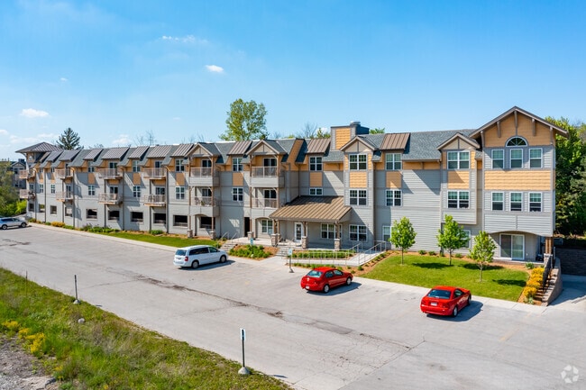
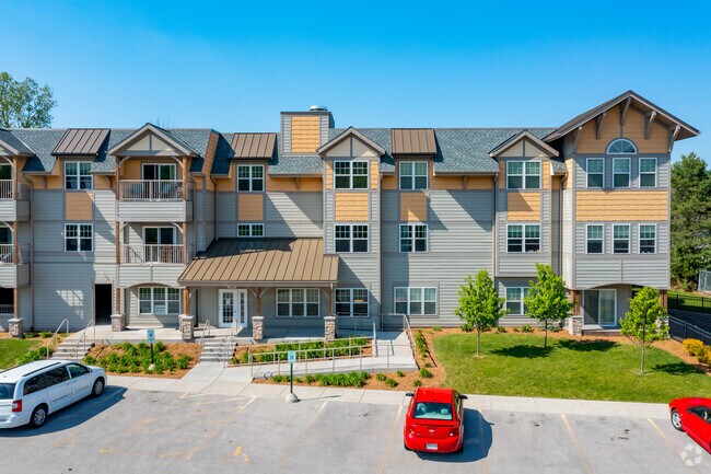
2848 N Brookfield Rd
Milwaukee-Waukesha-West Allis, WI
Certified Surv Map 5930
BRC-1070-997-002
PAR 2 CSM 5930 BEING A REDIV OF CSM 2526 AS RECORDED IN VOL18 OF CSMS ON PGS 203-206 AS DOC 943696 BEING A PT OF THE NW 1/4 OF SEC 16 T7N R20E 67,521 SQ FT 1.5501 ACRES
Commercialnec
Waukesha
X
Wisconsin
55133C0209H
2
2024
1.56 AC
2024
Eastern Waukesha
200804
Milwaukee/Madison
DEMOGRAPHICS near 2848 N Brookfield Rd
1 Mile
3 Mile
5 Mile
2024 Total Population
5,915
41,947
106,862
2029 Population
6,223
43,897
110,733
Pop Growth 2024-2029
+ 5.21%
+ 4.65%
+ 3.62%
Average Age
43
43
43
2024 Total Households
2,432
15,922
43,845
HH Growth 2024-2029
+ 5.18%
+ 4.75%
+ 3.57%
Median Household Inc
$98,981
$116,580
$96,924
Avg Household Size
2.40
2.60
2.40
2024 Avg HH Vehicles
2.00
2.00
2.00
Median Home Value
$388,418
$398,206
$355,780
Median Year Built
1986
1980
1979
Nearby Places
Map Layers
Map Styles
 Street
 Aerial
- Restaurants
- Banks
- Shops
- Fitness
- Groceries
PUBLIC TRANSPORTATION
AIRPORT
General Mitchell International
DRIVE
WALK
Distance
General Mitchell International
37 min
20.8 mi
Freight Ports
Port Milwaukee
DRIVE
WALK
Distance
Port Milwaukee
30 min
17.9 mi
Nearby Properties
Address
Land Use
TOTAL SIZE
Lot Size
Zoning
Address
Land Use
TOTAL SIZE
Lot Size
Zoning
19.44 AC
Address
Land Use
TOTAL SIZE
Lot Size
Zoning
19.44 AC
Address
Land Use
TOTAL SIZE
Lot Size
Zoning
12.50 AC
Address
Land Use
TOTAL SIZE
Lot Size
Zoning
20.02 AC
Address
Land Use
TOTAL SIZE
Lot Size
Zoning
34.31 AC
Address
Land Use
TOTAL SIZE
Lot Size
Zoning
10.48 AC
Address
Land Use
TOTAL SIZE
Lot Size
Zoning
Address
Land Use
TOTAL SIZE
Lot Size
Zoning
7.20 AC
Address
Land Use
TOTAL SIZE
Lot Size
Zoning
Address
Land Use
TOTAL SIZE
Lot Size
Zoning
19.44 AC
Address
Land Use
TOTAL SIZE
Lot Size
Zoning
Address
Land Use
TOTAL SIZE
Lot Size
Zoning
Address
Land Use
TOTAL SIZE
Lot Size
Zoning
21.87 AC
Address
Land Use
TOTAL SIZE
Lot Size
Zoning
3.55 AC
Address
Land Use
TOTAL SIZE
Lot Size
Zoning
Address
Land Use
TOTAL SIZE
Lot Size
Zoning
Address
Land Use
TOTAL SIZE
Lot Size
Zoning
192,963 SF
16.43 AC
Address
Land Use
TOTAL SIZE
Lot Size
Zoning
11.34 AC
Address
Land Use
TOTAL SIZE
Lot Size
Zoning
13.14 AC
Address
Land Use
TOTAL SIZE
Lot Size
Zoning
Address
Land Use
TOTAL SIZE
Lot Size
Zoning
16.79 AC
Address
Land Use
TOTAL SIZE
Lot Size
Zoning
10.41 AC
Address
Land Use
TOTAL SIZE
Lot Size
Zoning
4.94 AC
Address
Land Use
TOTAL SIZE
Lot Size
Zoning
10.53 AC
Address
Land Use
TOTAL SIZE
Lot Size
Zoning
9.57 AC
Address
Land Use
TOTAL SIZE
Lot Size
Zoning
11.09 AC
Address
Land Use
TOTAL SIZE
Lot Size
Zoning
Address
Land Use
TOTAL SIZE
Lot Size
Zoning
Address
Land Use
TOTAL SIZE
Lot Size
Zoning
Address
Land Use
TOTAL SIZE
Lot Size
Zoning
The World's #1 Commercial Real Estate Marketplace
Connect with us
© 2026 CoStar Group
The information above has been obtained from sources believed reliable. While we do not doubt its accuracy we have not verified it and make no guarantee, warranty or representation about it. It is your responsibility to independently confirm its accuracy and completeness. Any projections, opinions, assumptions, or estimates used are for example only and do not represent the current or future performance of the property. The value of this transaction to you depends on tax and other factors which should be evaluated by your tax, financial, and legal advisors. You and your advisors should conduct a careful, independent investigation of the property to determine to your satisfaction the suitability of the property for your needs.