Property Record
285 Aviation Dr, China Grove, NC 28023


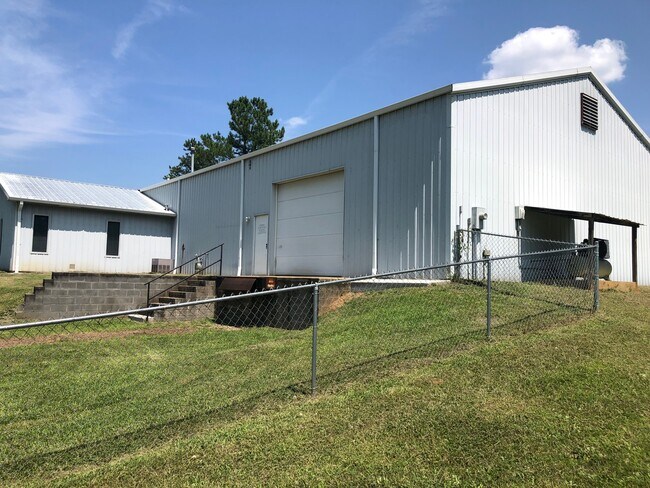
Property Detail
285 Aviation Dr
133-259
PT L 5 1.27AC
Industrialgeneral
Rowan
M1:LIGHT I
North Carolina
B and X Area of moderate flood hazard, usually the area between the limits of the 100-year and 500-year floods.
1.27 AC
2025
Rowan County
2025
Charlotte
051400
Charlotte-Concord-Gastonia, NC-SC
3,800 SF
NEARBY LISTINGS FOR SALE OR LEASE
-
-
View all China Grove listings for sale on LoopNet.com
DEMOGRAPHICS near 285 Aviation Dr
1 mile
3 mile
5 mile
2025 Total Population
3,006
27,936
64,681
2030 Population
3,137
29,402
68,546
Pop Growth 2025-2030
+ 4.36%
+ 5.25%
+ 5.98%
Average Age
39
40
40
2025 Total Households
1,209
10,965
25,425
HH Growth 2025-2030
+ 4.47%
+ 5.35%
+ 6.13%
Median Household Inc
$79,759
$62,665
$60,363
Avg Household Size
2.50
2.50
2.50
2025 Avg HH Vehicles
2.00
2.00
2.00
Median Home Value
$279,930
$245,882
$252,702
Median Year Built
1982
1977
1978
Nearby Places
Map Layers
Map Styles
 Street
 Aerial
Layers
 Traffic
 Biking
Places
Listings with unknown addresses are not visible on the map
- Restaurants
- Banks
- Shops
- Fitness
- Groceries
PUBLIC TRANSPORTATION
COMMUTER RAIL
Kannapolis Station (Piedmont - North Carolina by Train (NC Train))
Drive
Walk
Distance
Kannapolis Station (Piedmont - North Carolina by Train (NC Train))
8 min
4.1 mi
AIRPORT
Concord-Padgett Regional
Drive
Walk
Distance
Concord-Padgett Regional
27 min
16.5 mi
Charlotte/Douglas International
Drive
Walk
Distance
Charlotte/Douglas International
53 min
36.8 mi
SALE & LEASE HISTORY
LISTING DATE
SALE/LEASE

Oct 30, 2023
For Sale
Mar 27, 2023
For Sale
Aug 05, 2022
For Lease
Aug 05, 2022
For Sale
Nearby Properties
Address
Land Use
TOTAL SIZE
Lot Size
Zoning
Address
Land Use
TOTAL SIZE
Lot Size
Zoning
728,000 SF
51.80 AC
Address
Land Use
TOTAL SIZE
Lot Size
Zoning
297,600 SF
16.28 AC
Address
Land Use
TOTAL SIZE
Lot Size
Zoning
279,000 SF
23.48 AC
Address
Land Use
TOTAL SIZE
Lot Size
Zoning
67,862 SF
1.77 AC
CC
Address
Land Use
TOTAL SIZE
Lot Size
Zoning
55,888 SF
39.43 AC
Address
Land Use
TOTAL SIZE
Lot Size
Zoning
128,280 SF
10.82 AC
Address
Land Use
TOTAL SIZE
Lot Size
Zoning
269,700 SF
76.24 AC
Address
Land Use
TOTAL SIZE
Lot Size
Zoning
50,366 SF
1.64 AC
CC
Address
Land Use
TOTAL SIZE
Lot Size
Zoning
35,850 SF
34 AC
Address
Land Use
TOTAL SIZE
Lot Size
Zoning
83,701 SF
2.99 AC
R4
Address
Land Use
TOTAL SIZE
Lot Size
Zoning
21,906 SF
7.50 AC
OI:OFFICE
Address
Land Use
TOTAL SIZE
Lot Size
Zoning
37,300 SF
20.95 AC
RM2:MULTI
Address
Land Use
TOTAL SIZE
Lot Size
Zoning
39.58 AC
CC
Address
Land Use
TOTAL SIZE
Lot Size
Zoning
44,149 SF
11.26 AC
Address
Land Use
TOTAL SIZE
Lot Size
Zoning
72,726 SF
7.14 AC
GC
Address
Land Use
TOTAL SIZE
Lot Size
Zoning
146,346 SF
16.39 AC
Address
Land Use
TOTAL SIZE
Lot Size
Zoning
34,288 SF
5.61 AC
O-I
Address
Land Use
TOTAL SIZE
Lot Size
Zoning
14,258 SF
137.98 AC
RM1:MULTI
Address
Land Use
TOTAL SIZE
Lot Size
Zoning
58,300 SF
14.53 AC
R8:SINGLE
Address
Land Use
TOTAL SIZE
Lot Size
Zoning
19,951 SF
9.12 AC
OI:OFFICE
Address
Land Use
TOTAL SIZE
Lot Size
Zoning
43,091 SF
21.39 AC
Address
Land Use
TOTAL SIZE
Lot Size
Zoning
139,812 SF
17.35 AC
Address
Land Use
TOTAL SIZE
Lot Size
Zoning
99.27 AC
Address
Land Use
TOTAL SIZE
Lot Size
Zoning
8,941 SF
2.36 AC
Address
Land Use
TOTAL SIZE
Lot Size
Zoning
1,640 SF
21.46 AC
Address
Land Use
TOTAL SIZE
Lot Size
Zoning
13,770 SF
1.28 AC
GC
Address
Land Use
TOTAL SIZE
Lot Size
Zoning
30,284 SF
12.51 AC
Address
Land Use
TOTAL SIZE
Lot Size
Zoning
45,450 SF
5.01 AC
C2:HIGHWAY
Address
Land Use
TOTAL SIZE
Lot Size
Zoning
3,200 SF
259.49 AC
Address
Land Use
TOTAL SIZE
Lot Size
Zoning
27,467 SF
52.01 AC
R1:SINGLE
The World's #1 Commercial Real Estate Marketplace
Connect with us
© 2026 CoStar Group
The information above has been obtained from sources believed reliable. While we do not doubt its accuracy we have not verified it and make no guarantee, warranty or representation about it. It is your responsibility to independently confirm its accuracy and completeness. Any projections, opinions, assumptions, or estimates used are for example only and do not represent the current or future performance of the property. The value of this transaction to you depends on tax and other factors which should be evaluated by your tax, financial, and legal advisors. You and your advisors should conduct a careful, independent investigation of the property to determine to your satisfaction the suitability of the property for your needs.