Property Record
285 Easy St, Greenville, NC 27834


Save to a Folder
{{folder.Name}}
{{folder.ListingIds.length}} Properties
{{folder.ListingIds.length}} Property
Create a New Folder
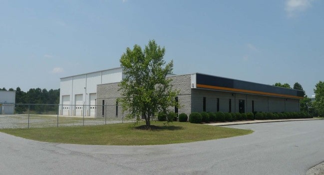
Property Detail
285 Easy St
062060
GREENFIELD PARK
Manufacturinglight
PITT
CH
North Carolina
C and X Area of minimal flood hazard, usually depicted on FIRMs as above the 500-year flood level.
14.rev
0
9.44 AC
2025
North Carolina Northeast Area
000800
Other Market Areas
16,425 SF
Greenville, NC
NEARBY LISTINGS FOR SALE OR LEASE
DEMOGRAPHICS near 285 Easy St
1 mile
3 mile
5 mile
2025 Total Population
1,183
21,099
63,998
2030 Population
1,228
22,161
67,002
Pop Growth 2025-2030
+ 3.80%
+ 5.03%
+ 4.69%
Average Age
41
32
34
2025 Total Households
445
7,035
25,860
HH Growth 2025-2030
+ 3.60%
+ 6.74%
+ 5.24%
Median Household Inc
$39,014
$31,547
$45,791
Avg Household Size
2.50
2.10
2.10
2025 Avg HH Vehicles
2.00
2.00
2.00
Median Home Value
$145,774
$141,853
$178,288
Median Year Built
1989
1990
1990
Nearby Places
Map Layers
Map Styles
 Street
 Aerial
Layers
 Traffic
 Biking
Places
Listings with unknown addresses are not visible on the map
- Restaurants
- Banks
- Shops
- Fitness
- Groceries
PUBLIC TRANSPORTATION
AIRPORT
Pitt-Greenville
Drive
Walk
Distance
Pitt-Greenville
6 min
2.1 mi
Nearby Properties
Address
Land Use
TOTAL SIZE
Lot Size
Zoning
Address
Land Use
TOTAL SIZE
Lot Size
Zoning
1,585,097 SF
142.93 AC
IU
Address
Land Use
TOTAL SIZE
Lot Size
Zoning
339,992 SF
115.67 AC
CH
Address
Land Use
TOTAL SIZE
Lot Size
Zoning
506,392 SF
86.99 AC
IU
Address
Land Use
TOTAL SIZE
Lot Size
Zoning
146,413 SF
12.18 AC
MO
Address
Land Use
TOTAL SIZE
Lot Size
Zoning
253,726 SF
35.42 AC
PIU
Address
Land Use
TOTAL SIZE
Lot Size
Zoning
180,500 SF
2.17 AC
CD
Address
Land Use
TOTAL SIZE
Lot Size
Zoning
348,438 SF
3.89 AC
CD
Address
Land Use
TOTAL SIZE
Lot Size
Zoning
232,380 SF
666.85 AC
IU
Address
Land Use
TOTAL SIZE
Lot Size
Zoning
328,680 SF
2.04 AC
CD
Address
Land Use
TOTAL SIZE
Lot Size
Zoning
38,214 SF
40.39 AC
OR
Address
Land Use
TOTAL SIZE
Lot Size
Zoning
109,461 SF
1.89 AC
CD
Address
Land Use
TOTAL SIZE
Lot Size
Zoning
536,862 SF
38.22 AC
PIU
Address
Land Use
TOTAL SIZE
Lot Size
Zoning
267,434 SF
15.37 AC
PIU
Address
Land Use
TOTAL SIZE
Lot Size
Zoning
849,820 SF
77.56 AC
I
Address
Land Use
TOTAL SIZE
Lot Size
Zoning
442,815 SF
47.96 AC
I
Address
Land Use
TOTAL SIZE
Lot Size
Zoning
124,730 SF
16.75 AC
PIU
Address
Land Use
TOTAL SIZE
Lot Size
Zoning
169,247 SF
1.97 AC
CD
Address
Land Use
TOTAL SIZE
Lot Size
Zoning
67,785 SF
0.12 AC
CD
Address
Land Use
TOTAL SIZE
Lot Size
Zoning
8,890 SF
14.84 AC
R6
Address
Land Use
TOTAL SIZE
Lot Size
Zoning
42,296 SF
147.15 AC
RA20
Address
Land Use
TOTAL SIZE
Lot Size
Zoning
23,235 SF
10.13 AC
MR
Address
Land Use
TOTAL SIZE
Lot Size
Zoning
415,292 SF
68.94 AC
I
Address
Land Use
TOTAL SIZE
Lot Size
Zoning
111,408 SF
0.63 AC
CD
Address
Land Use
TOTAL SIZE
Lot Size
Zoning
8,649 SF
10.97 AC
R6
Address
Land Use
TOTAL SIZE
Lot Size
Zoning
51,290 SF
1.49 AC
CD
Address
Land Use
TOTAL SIZE
Lot Size
Zoning
90,632 SF
12.37 AC
IU
Address
Land Use
TOTAL SIZE
Lot Size
Zoning
27,012 SF
9.44 AC
R6
Address
Land Use
TOTAL SIZE
Lot Size
Zoning
233,534 SF
24.51 AC
IU
Address
Land Use
TOTAL SIZE
Lot Size
Zoning
53,410 SF
4 AC
OR
Address
Land Use
TOTAL SIZE
Lot Size
Zoning
15,376 SF
8.13 AC
CD
The World's #1 Commercial Real Estate Marketplace
Connect with us
© 2026 CoStar Group
The information above has been obtained from sources believed reliable. While we do not doubt its accuracy we have not verified it and make no guarantee, warranty or representation about it. It is your responsibility to independently confirm its accuracy and completeness. Any projections, opinions, assumptions, or estimates used are for example only and do not represent the current or future performance of the property. The value of this transaction to you depends on tax and other factors which should be evaluated by your tax, financial, and legal advisors. You and your advisors should conduct a careful, independent investigation of the property to determine to your satisfaction the suitability of the property for your needs.