Property Record
285 Hatfield Blvd, Ashburn, GA 31714

Save to a Folder
{{folder.Name}}
{{folder.ListingIds.length}} Properties
{{folder.ListingIds.length}} Property
Create a New Folder
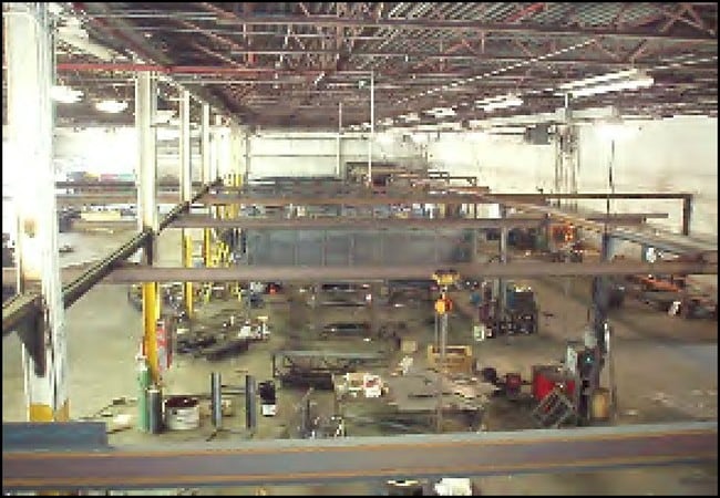
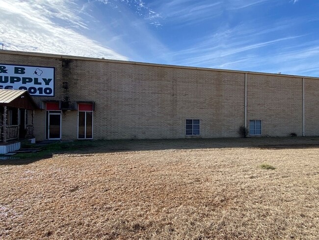
Property Detail
285 Hatfield Blvd
027-051
LD2 LL110 12.94AC
Warehouse
Turner
003
Georgia
B and X Area of moderate flood hazard, usually the area between the limits of the 100-year and 500-year floods.
110
2025
12.94 AC
2025
Georgia South Area
970300
Other Market Areas
36,100 SF
Tifton, GA
NEARBY LISTINGS FOR SALE OR LEASE
DEMOGRAPHICS near 285 Hatfield Blvd
1 mile
3 mile
5 mile
2025 Total Population
217
5,989
6,764
2030 Population
217
5,998
6,769
Pop Growth 2025-2030
0.00%
+ 0.15%
+ 0.07%
Average Age
42
40
40
2025 Total Households
81
2,267
2,573
HH Growth 2025-2030
0.00%
+ 0.04%
+ 0.04%
Median Household Inc
$69,166
$35,424
$36,805
Avg Household Size
2.40
2.40
2.40
2025 Avg HH Vehicles
2.00
2.00
2.00
Median Home Value
$158,695
$95,029
$99,343
Median Year Built
1976
1972
1973
Nearby Places
Map Layers
Map Styles
 Street
 Aerial
Layers
 Traffic
 Biking
Places
Listings with unknown addresses are not visible on the map
- Restaurants
- Banks
- Shops
- Fitness
- Groceries
SALE & LEASE HISTORY
LISTING DATE
SALE/LEASE

Mar 02, 2021
For Sale
Nearby Properties
Address
Land Use
TOTAL SIZE
Lot Size
Zoning
Address
Land Use
TOTAL SIZE
Lot Size
Zoning
173,518 SF
21.43 AC
003
Address
Land Use
TOTAL SIZE
Lot Size
Zoning
4,610 SF
12.71 AC
002
Address
Land Use
TOTAL SIZE
Lot Size
Zoning
39,456 SF
6.86 AC
005
Address
Land Use
TOTAL SIZE
Lot Size
Zoning
144,000 SF
6.14 AC
002
Address
Land Use
TOTAL SIZE
Lot Size
Zoning
45,800 SF
10 AC
007
Address
Land Use
TOTAL SIZE
Lot Size
Zoning
4,132 SF
12.95 AC
007
Address
Land Use
TOTAL SIZE
Lot Size
Zoning
43,750 SF
12.08 AC
002
Address
Land Use
TOTAL SIZE
Lot Size
Zoning
2.10 AC
001
Address
Land Use
TOTAL SIZE
Lot Size
Zoning
7,875 SF
2.05 AC
002
Address
Land Use
TOTAL SIZE
Lot Size
Zoning
13,553 SF
12.08 AC
003
Address
Land Use
TOTAL SIZE
Lot Size
Zoning
2,050 SF
4.92 AC
002
Address
Land Use
TOTAL SIZE
Lot Size
Zoning
1,539 SF
13.55 AC
003
Address
Land Use
TOTAL SIZE
Lot Size
Zoning
2,834 SF
13.10 AC
002
Address
Land Use
TOTAL SIZE
Lot Size
Zoning
59,500 SF
4.97 AC
007
Address
Land Use
TOTAL SIZE
Lot Size
Zoning
30,426 SF
4.97 AC
002
Address
Land Use
TOTAL SIZE
Lot Size
Zoning
2,146 SF
3.67 AC
002
Address
Land Use
TOTAL SIZE
Lot Size
Zoning
40,800 SF
8.60 AC
002
Address
Land Use
TOTAL SIZE
Lot Size
Zoning
15,000 SF
4.04 AC
003
Address
Land Use
TOTAL SIZE
Lot Size
Zoning
8,958 SF
8.66 AC
002
Address
Land Use
TOTAL SIZE
Lot Size
Zoning
1.66 AC
001
Address
Land Use
TOTAL SIZE
Lot Size
Zoning
487.69 AC
004
Address
Land Use
TOTAL SIZE
Lot Size
Zoning
15,400 SF
1.37 AC
002
Address
Land Use
TOTAL SIZE
Lot Size
Zoning
10,293 SF
1.19 AC
002
Address
Land Use
TOTAL SIZE
Lot Size
Zoning
13,155 SF
2.76 AC
002
Address
Land Use
TOTAL SIZE
Lot Size
Zoning
4.82 AC
001
Address
Land Use
TOTAL SIZE
Lot Size
Zoning
15,402 SF
1.29 AC
002
Address
Land Use
TOTAL SIZE
Lot Size
Zoning
5.07 AC
001
Address
Land Use
TOTAL SIZE
Lot Size
Zoning
82,383 SF
10 AC
002
Address
Land Use
TOTAL SIZE
Lot Size
Zoning
6,732 SF
1.39 AC
002
The World's #1 Commercial Real Estate Marketplace
Connect with us
© 2026 CoStar Group
The information above has been obtained from sources believed reliable. While we do not doubt its accuracy we have not verified it and make no guarantee, warranty or representation about it. It is your responsibility to independently confirm its accuracy and completeness. Any projections, opinions, assumptions, or estimates used are for example only and do not represent the current or future performance of the property. The value of this transaction to you depends on tax and other factors which should be evaluated by your tax, financial, and legal advisors. You and your advisors should conduct a careful, independent investigation of the property to determine to your satisfaction the suitability of the property for your needs.