Property Record
285 Maple Pky, Staten Island, NY 10303
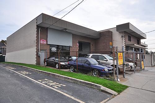

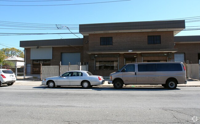
Property Detail
285 Maple Pky
01222-0007
Richmond
Autorepair
New York
R3-2
7
B and X Area of moderate flood hazard, usually the area between the limits of the 100-year and 500-year floods.
0.11 AC
2024
Staten Island
2025
Long Island (New York)
023100
New York-Jersey City-White Plains, NY-NJ
3,200 SF
NEARBY LISTINGS FOR SALE OR LEASE
DEMOGRAPHICS near 285 Maple Pky
1 mile
3 mile
5 mile
2025 Total Population
42,609
214,354
584,190
2030 Population
42,576
215,626
594,787
Pop Growth 2025-2030
(0.08%)
+ 0.59%
+ 1.81%
Average Age
39
39
40
2025 Total Households
13,638
72,082
204,246
HH Growth 2025-2030
(0.06%)
+ 0.72%
+ 2.00%
Median Household Inc
$96,015
$88,065
$81,739
Avg Household Size
3.00
2.90
2.70
2025 Avg HH Vehicles
1.00
1.00
1.00
Median Home Value
$624,696
$682,886
$657,583
Median Year Built
1973
1967
1966
Nearby Places
Map Layers
Map Styles
 Street
 Aerial
Layers
 Traffic
 Biking
Places
Listings with unknown addresses are not visible on the map
- Restaurants
- Banks
- Shops
- Fitness
- Groceries
PUBLIC TRANSPORTATION
COMMUTER RAIL
Jefferson Avenue (Staten Island Railway - New York MTA Subway (The Subway))
Drive
Walk
Distance
Jefferson Avenue (Staten Island Railway - New York MTA Subway (The Subway))
15 min
6.2 mi
Dongan Hills (Staten Island Railway - New York MTA Subway (The Subway))
Drive
Walk
Distance
Dongan Hills (Staten Island Railway - New York MTA Subway (The Subway))
14 min
6.9 mi
AIRPORT
Newark Liberty International
Drive
Walk
Distance
Newark Liberty International
18 min
11.4 mi
LaGuardia
Drive
Walk
Distance
LaGuardia
43 min
25.8 mi
John F Kennedy International
Drive
Walk
Distance
John F Kennedy International
42 min
28.4 mi
Freight Ports
New York Container Terminal
Drive
Walk
Distance
New York Container Terminal
4 min
2.1 mi
Nearby Properties
Address
Land Use
TOTAL SIZE
Lot Size
Zoning
Address
Land Use
TOTAL SIZE
Lot Size
Zoning
28.40 AC
Address
Land Use
TOTAL SIZE
Lot Size
Zoning
633,280 SF
202.90 AC
R3-2
Address
Land Use
TOTAL SIZE
Lot Size
Zoning
4,450,000 SF
95.24 AC
Address
Land Use
TOTAL SIZE
Lot Size
Zoning
22.49 AC
HC
Address
Land Use
TOTAL SIZE
Lot Size
Zoning
686,130 SF
189.62 AC
R3-2
Address
Land Use
TOTAL SIZE
Lot Size
Zoning
70.39 AC
Address
Land Use
TOTAL SIZE
Lot Size
Zoning
16.63 AC
Address
Land Use
TOTAL SIZE
Lot Size
Zoning
2.21 AC
Address
Land Use
TOTAL SIZE
Lot Size
Zoning
1.01 AC
Address
Land Use
TOTAL SIZE
Lot Size
Zoning
51.62 AC
Address
Land Use
TOTAL SIZE
Lot Size
Zoning
91,760 SF
210.43 AC
M3-1
Address
Land Use
TOTAL SIZE
Lot Size
Zoning
Address
Land Use
TOTAL SIZE
Lot Size
Zoning
3,500,000 SF
11.97 AC
MRC2
Address
Land Use
TOTAL SIZE
Lot Size
Zoning
51.61 AC
Address
Land Use
TOTAL SIZE
Lot Size
Zoning
39.64 AC
Address
Land Use
TOTAL SIZE
Lot Size
Zoning
566,000 SF
103.31 AC
R3-2
Address
Land Use
TOTAL SIZE
Lot Size
Zoning
6,188,000 SF
8.18 AC
Address
Land Use
TOTAL SIZE
Lot Size
Zoning
1 SF
20 AC
Address
Land Use
TOTAL SIZE
Lot Size
Zoning
11.14 AC
Address
Land Use
TOTAL SIZE
Lot Size
Zoning
855,000 SF
48.74 AC
M3-1
Address
Land Use
TOTAL SIZE
Lot Size
Zoning
10 SF
9.18 AC
Address
Land Use
TOTAL SIZE
Lot Size
Zoning
1,502 SF
0.69 AC
C-1
Address
Land Use
TOTAL SIZE
Lot Size
Zoning
24.19 AC
Address
Land Use
TOTAL SIZE
Lot Size
Zoning
131.25 AC
PARK
Address
Land Use
TOTAL SIZE
Lot Size
Zoning
23.77 AC
Address
Land Use
TOTAL SIZE
Lot Size
Zoning
538,240 SF
12.08 AC
R2
Address
Land Use
TOTAL SIZE
Lot Size
Zoning
2.38 AC
Address
Land Use
TOTAL SIZE
Lot Size
Zoning
494,840 SF
34.77 AC
R3-2
Address
Land Use
TOTAL SIZE
Lot Size
Zoning
Address
Land Use
TOTAL SIZE
Lot Size
Zoning
970,000 SF
55.25 AC
M3-1
The World's #1 Commercial Real Estate Marketplace
Connect with us
© 2026 CoStar Group
The information above has been obtained from sources believed reliable. While we do not doubt its accuracy we have not verified it and make no guarantee, warranty or representation about it. It is your responsibility to independently confirm its accuracy and completeness. Any projections, opinions, assumptions, or estimates used are for example only and do not represent the current or future performance of the property. The value of this transaction to you depends on tax and other factors which should be evaluated by your tax, financial, and legal advisors. You and your advisors should conduct a careful, independent investigation of the property to determine to your satisfaction the suitability of the property for your needs.