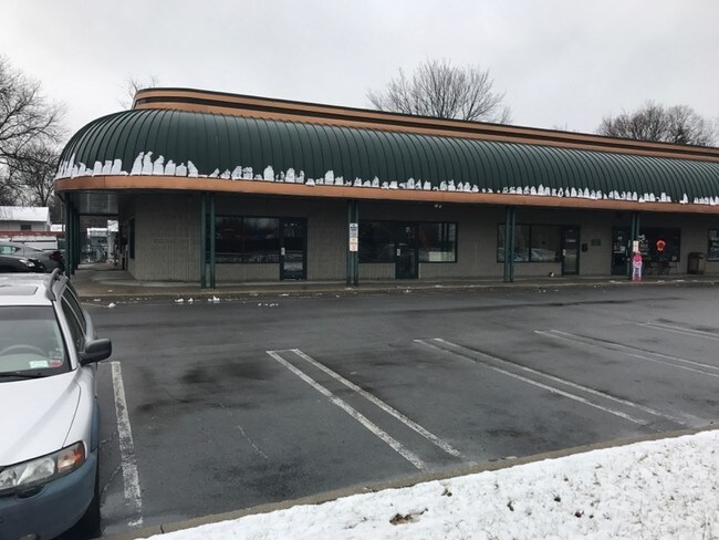
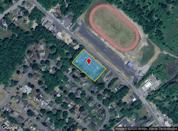
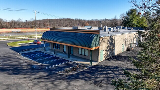
Property Record
285 Route 211 W, Middletown, NY 10940

NEARBY LISTINGS FOR SALE OR LEASE
Property Detail
285 Route 211 W
New York-Jersey City-White Plains, NY-NJ
Mc Namee
335200-049-000-0001-071.100-0000
LT 2 MC NAMEE SUB MP 6308
Regionalshoppingcenterormallwithanchorstore
Orange
X
New York
36071C0255E
71.10
2024
1.20 AC
2024
Middletown
011400
Northern New Jersey
7,620 SF
DEMOGRAPHICS near 285 Route 211 W
1 Mile
3 Mile
5 Mile
2024 Total Population
4,876
44,375
67,710
2029 Population
4,939
45,163
68,941
Pop Growth 2024-2029
+ 1.29%
+ 1.78%
+ 1.82%
Average Age
39
39
40
2024 Total Households
1,733
16,612
24,577
HH Growth 2024-2029
+ 1.44%
+ 1.94%
+ 1.98%
Median Household Inc
$104,707
$70,642
$79,677
Avg Household Size
2.70
2.60
2.60
2024 Avg HH Vehicles
2.00
2.00
2.00
Median Home Value
$257,454
$253,248
$268,097
Median Year Built
1949
1970
1974
Nearby Places
- Restaurants
- Banks
- Shops
- Fitness
- Groceries
PUBLIC TRANSPORTATION
COMMUTER RAIL
Middletown New York (Bergen County/Port Jervis Line - NJ Transit Commuter Rail (NJ Transit), Main/Port Jervis Line - NJ Transit Commuter Rail (NJ Transit))
DRIVE
WALK
Distance
Middletown New York (Bergen County/Port Jervis Line - NJ Transit Commuter Rail (NJ Transit), Main/Port Jervis Line - NJ Transit Commuter Rail (NJ Transit))
10 min
4.7 mi
Otisville (Bergen County/Port Jervis Line - NJ Transit Commuter Rail (NJ Transit), Main/Port Jervis Line - NJ Transit Commuter Rail (NJ Transit))
DRIVE
WALK
Distance
Otisville (Bergen County/Port Jervis Line - NJ Transit Commuter Rail (NJ Transit), Main/Port Jervis Line - NJ Transit Commuter Rail (NJ Transit))
8 min
5.7 mi
AIRPORT
New York Stewart International
DRIVE
WALK
Distance
New York Stewart International
34 min
24.9 mi
Freight Ports
Port Newark Container Terminal
DRIVE
WALK
Distance
Port Newark Container Terminal
98 min
73.5 mi
SALE & LEASE HISTORY
LISTING DATE
SALE/LEASE

Jun 14, 2024
For Lease
Jan 04, 2017
For Lease
Dec 14, 2022
For Sale
Aug 28, 2017
For Lease
Apr 24, 2024
For Lease
Nearby Properties
Address
Land Use
TOTAL SIZE
Lot Size
Zoning
Address
Land Use
TOTAL SIZE
Lot Size
Zoning
Address
Land Use
TOTAL SIZE
Lot Size
Zoning
40.40 AC
I-2
Address
Land Use
TOTAL SIZE
Lot Size
Zoning
24.40 AC
R-1
Address
Land Use
TOTAL SIZE
Lot Size
Zoning
29,950 SF
3 AC
TC-1
Address
Land Use
TOTAL SIZE
Lot Size
Zoning
17.60 AC
R-1
Address
Land Use
TOTAL SIZE
Lot Size
Zoning
50,700 SF
7.70 AC
TC-1
Address
Land Use
TOTAL SIZE
Lot Size
Zoning
142,416 SF
13.90 AC
R1
Address
Land Use
TOTAL SIZE
Lot Size
Zoning
26,156 SF
0.01 AC
TC-1
Address
Land Use
TOTAL SIZE
Lot Size
Zoning
5,832 SF
2.30 AC
TC-1
Address
Land Use
TOTAL SIZE
Lot Size
Zoning
208,464 SF
24.90 AC
HC
Address
Land Use
TOTAL SIZE
Lot Size
Zoning
7 AC
C-3
Address
Land Use
TOTAL SIZE
Lot Size
Zoning
6.80 AC
MC 1
Address
Land Use
TOTAL SIZE
Lot Size
Zoning
96,231 SF
14.80 AC
HC
Address
Land Use
TOTAL SIZE
Lot Size
Zoning
41,728 SF
5 AC
TC-1
Address
Land Use
TOTAL SIZE
Lot Size
Zoning
726 SF
40.30 AC
C-3
Address
Land Use
TOTAL SIZE
Lot Size
Zoning
4.90 AC
Address
Land Use
TOTAL SIZE
Lot Size
Zoning
91,794 SF
7.70 AC
R1
Address
Land Use
TOTAL SIZE
Lot Size
Zoning
12.60 AC
R-1
Address
Land Use
TOTAL SIZE
Lot Size
Zoning
55,972 SF
0.85 AC
DN
Address
Land Use
TOTAL SIZE
Lot Size
Zoning
14.10 AC
PID
Address
Land Use
TOTAL SIZE
Lot Size
Zoning
161,328 SF
20 AC
R1
Address
Land Use
TOTAL SIZE
Lot Size
Zoning
24.90 AC
R-AH
Address
Land Use
TOTAL SIZE
Lot Size
Zoning
85,895 SF
31.80 AC
R1
Address
Land Use
TOTAL SIZE
Lot Size
Zoning
11.50 AC
SR-3B
Address
Land Use
TOTAL SIZE
Lot Size
Zoning
19.20 AC
C-3
Address
Land Use
TOTAL SIZE
Lot Size
Zoning
160,336 SF
12.10 AC
R1
Address
Land Use
TOTAL SIZE
Lot Size
Zoning
27,662 SF
85.50 AC
R1
Address
Land Use
TOTAL SIZE
Lot Size
Zoning
125,144 SF
6.60 AC
Address
Land Use
TOTAL SIZE
Lot Size
Zoning
3.70 AC
R-1
Address
Land Use
TOTAL SIZE
Lot Size
Zoning
21.20 AC
The World's #1 Commercial Real Estate Marketplace
Connect with us
© 2025 CoStar Group
The information above has been obtained from sources believed reliable. While we do not doubt its accuracy we have not verified it and make no guarantee, warranty or representation about it. It is your responsibility to independently confirm its accuracy and completeness. Any projections, opinions, assumptions, or estimates used are for example only and do not represent the current or future performance of the property. The value of this transaction to you depends on tax and other factors which should be evaluated by your tax, financial, and legal advisors. You and your advisors should conduct a careful, independent investigation of the property to determine to your satisfaction the suitability of the property for your needs.