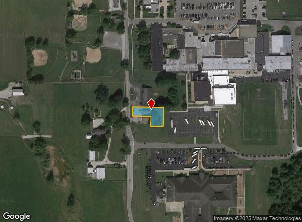
Property Record
285 S Chestnut St, Monrovia, IN 46157
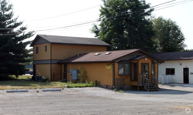
This Property Is For Sale
NEARBY LISTINGS FOR SALE OR LEASE
-
-
View all Monrovia listings for sale on LoopNet.com
Property Detail
285 S Chestnut St
55-04-12-300-003.000-022
S12 T13 T1W PT S SW .31 A
Apartment
Morgan
X
Indiana
18109C0130E
0.31 AC
2024
Morgan County
2024
Indianapolis
510402
Indianapolis-Carmel-Anderson, IN
2,320 SF
DEMOGRAPHICS near 285 S Chestnut St
1 Mile
3 Mile
5 Mile
2024 Total Population
1,404
5,130
11,422
2029 Population
1,452
5,248
11,737
Pop Growth 2024-2029
+ 3.42%
+ 2.30%
+ 2.76%
Average Age
37
40
42
2024 Total Households
488
1,898
4,305
HH Growth 2024-2029
+ 3.48%
+ 2.21%
+ 2.72%
Median Household Inc
$83,967
$89,921
$83,294
Avg Household Size
2.80
2.70
2.60
2024 Avg HH Vehicles
3.00
3.00
3.00
Median Home Value
$177,405
$203,757
$227,201
Median Year Built
2004
1991
1981
Nearby Places
Map Layers
Map Styles
 Street
 Aerial
- Restaurants
- Banks
- Shops
- Fitness
- Groceries
PUBLIC TRANSPORTATION
AIRPORT
Indianapolis International
DRIVE
WALK
Distance
Indianapolis International
24 min
15.2 mi
Nearby Properties
Address
Land Use
TOTAL SIZE
Lot Size
Zoning
Address
Land Use
TOTAL SIZE
Lot Size
Zoning
76.76 AC
Address
Land Use
TOTAL SIZE
Lot Size
Zoning
60.85 AC
Address
Land Use
TOTAL SIZE
Lot Size
Zoning
577,046 SF
59.48 AC
Address
Land Use
TOTAL SIZE
Lot Size
Zoning
26.24 AC
Address
Land Use
TOTAL SIZE
Lot Size
Zoning
37.89 AC
Address
Land Use
TOTAL SIZE
Lot Size
Zoning
12,152 SF
10.66 AC
Address
Land Use
TOTAL SIZE
Lot Size
Zoning
17,389 SF
13.79 AC
Address
Land Use
TOTAL SIZE
Lot Size
Zoning
8,256 SF
1.03 AC
Address
Land Use
TOTAL SIZE
Lot Size
Zoning
15,306 SF
4.65 AC
Address
Land Use
TOTAL SIZE
Lot Size
Zoning
7,979 SF
1.44 AC
Address
Land Use
TOTAL SIZE
Lot Size
Zoning
2,392 SF
20.36 AC
Address
Land Use
TOTAL SIZE
Lot Size
Zoning
9,230 SF
0.96 AC
Address
Land Use
TOTAL SIZE
Lot Size
Zoning
6,565 SF
3.94 AC
Address
Land Use
TOTAL SIZE
Lot Size
Zoning
6,522 SF
0.92 AC
Address
Land Use
TOTAL SIZE
Lot Size
Zoning
5,448 SF
3.97 AC
Address
Land Use
TOTAL SIZE
Lot Size
Zoning
2,976 SF
21.63 AC
Address
Land Use
TOTAL SIZE
Lot Size
Zoning
Address
Land Use
TOTAL SIZE
Lot Size
Zoning
1,463 SF
0.35 AC
Address
Land Use
TOTAL SIZE
Lot Size
Zoning
8,120 SF
0.92 AC
Address
Land Use
TOTAL SIZE
Lot Size
Zoning
5,136 SF
0.92 AC
Address
Land Use
TOTAL SIZE
Lot Size
Zoning
2,304 SF
0.42 AC
Address
Land Use
TOTAL SIZE
Lot Size
Zoning
7,500 SF
1.16 AC
Address
Land Use
TOTAL SIZE
Lot Size
Zoning
5,244 SF
2.62 AC
Address
Land Use
TOTAL SIZE
Lot Size
Zoning
31.03 AC
Address
Land Use
TOTAL SIZE
Lot Size
Zoning
5,000 SF
0.92 AC
Address
Land Use
TOTAL SIZE
Lot Size
Zoning
38.53 AC
Address
Land Use
TOTAL SIZE
Lot Size
Zoning
4,724 SF
1.29 AC
Address
Land Use
TOTAL SIZE
Lot Size
Zoning
Address
Land Use
TOTAL SIZE
Lot Size
Zoning
0.18 AC
The World's #1 Commercial Real Estate Marketplace
Connect with us
© 2026 CoStar Group
The information above has been obtained from sources believed reliable. While we do not doubt its accuracy we have not verified it and make no guarantee, warranty or representation about it. It is your responsibility to independently confirm its accuracy and completeness. Any projections, opinions, assumptions, or estimates used are for example only and do not represent the current or future performance of the property. The value of this transaction to you depends on tax and other factors which should be evaluated by your tax, financial, and legal advisors. You and your advisors should conduct a careful, independent investigation of the property to determine to your satisfaction the suitability of the property for your needs.