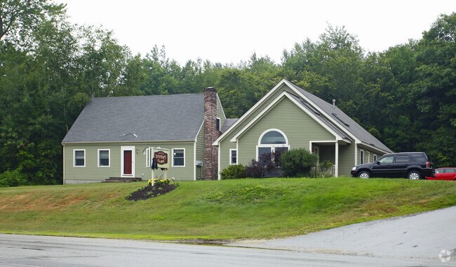
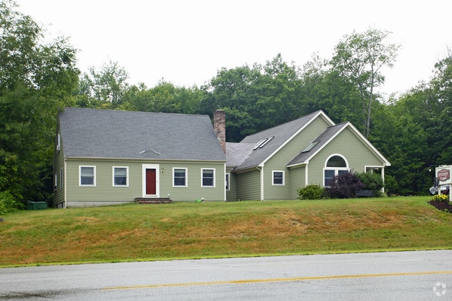
Property Record
285 White Mountain Hwy, Milton, NH 03851

NEARBY LISTINGS FOR SALE OR LEASE
-
-
View all Milton listings for sale on LoopNet.com
Property Detail
285 White Mountain Hwy
Commercialbuilding
Strafford
X
New Hampshire
23031C0363G
9.05 AC
2024
Strafford County
2024
Boston
088000
Boston-Cambridge-Newton, MA-NH
3,998 SF
MLTN-000045-000063
DEMOGRAPHICS near 285 White Mountain Hwy
1 Mile
3 Mile
5 Mile
2024 Total Population
729
6,978
17,067
2029 Population
751
7,259
17,775
Pop Growth 2024-2029
+ 3.02%
+ 4.03%
+ 4.15%
Average Age
41
43
43
2024 Total Households
281
2,828
6,962
HH Growth 2024-2029
+ 2.85%
+ 4.07%
+ 4.17%
Median Household Inc
$108,695
$102,793
$88,997
Avg Household Size
2.50
2.40
2.40
2024 Avg HH Vehicles
2.00
2.00
2.00
Median Home Value
$258,962
$264,338
$250,478
Median Year Built
1985
1983
1981
Nearby Places
Map Layers
Map Styles
 Street
 Aerial
- Restaurants
- Banks
- Shops
- Fitness
- Groceries
PUBLIC TRANSPORTATION
AIRPORT
Portsmouth International at Pease
DRIVE
WALK
Distance
Portsmouth International at Pease
40 min
28.0 mi
Nearby Properties
Address
Land Use
TOTAL SIZE
Lot Size
Zoning
Address
Land Use
TOTAL SIZE
Lot Size
Zoning
123,860 SF
8.75 AC
IND/CO
Address
Land Use
TOTAL SIZE
Lot Size
Zoning
61,383 SF
9.60 AC
HIGH D
Address
Land Use
TOTAL SIZE
Lot Size
Zoning
56.70 AC
LOW DE
Address
Land Use
TOTAL SIZE
Lot Size
Zoning
87.64 AC
A
Address
Land Use
TOTAL SIZE
Lot Size
Zoning
35,049 SF
4.61 AC
HIGH D
Address
Land Use
TOTAL SIZE
Lot Size
Zoning
39 AC
A
Address
Land Use
TOTAL SIZE
Lot Size
Zoning
6,000 SF
2.30 AC
IND/CO
Address
Land Use
TOTAL SIZE
Lot Size
Zoning
2,583 SF
1.30 AC
LOW DE
Address
Land Use
TOTAL SIZE
Lot Size
Zoning
10,750 SF
2 AC
IND/CO
Address
Land Use
TOTAL SIZE
Lot Size
Zoning
192,505 SF
25.50 AC
IND
Address
Land Use
TOTAL SIZE
Lot Size
Zoning
5,106 SF
3.65 AC
IND/CO
Address
Land Use
TOTAL SIZE
Lot Size
Zoning
14,895 SF
5.92 AC
IND/CO
Address
Land Use
TOTAL SIZE
Lot Size
Zoning
8,108 SF
3.18 AC
IND/CO
Address
Land Use
TOTAL SIZE
Lot Size
Zoning
5,413 SF
1.73 AC
HIGH D
Address
Land Use
TOTAL SIZE
Lot Size
Zoning
2,109 SF
1.80 AC
HIGH D
Address
Land Use
TOTAL SIZE
Lot Size
Zoning
6.70 AC
A
Address
Land Use
TOTAL SIZE
Lot Size
Zoning
39,090 SF
20.15 AC
RR RUR
Address
Land Use
TOTAL SIZE
Lot Size
Zoning
8.06 AC
LOW DE
Address
Land Use
TOTAL SIZE
Lot Size
Zoning
33.99 AC
COMM/R
Address
Land Use
TOTAL SIZE
Lot Size
Zoning
0.23 AC
LOW DE
Address
Land Use
TOTAL SIZE
Lot Size
Zoning
1,850 SF
1.44 AC
HC
Address
Land Use
TOTAL SIZE
Lot Size
Zoning
12,863 SF
2.95 AC
HIGH D
Address
Land Use
TOTAL SIZE
Lot Size
Zoning
2,811 SF
71.23 AC
LOW DE
Address
Land Use
TOTAL SIZE
Lot Size
Zoning
4,600 SF
0.63 AC
HIGH D
Address
Land Use
TOTAL SIZE
Lot Size
Zoning
1,922 SF
0.44 AC
LOW DE
Address
Land Use
TOTAL SIZE
Lot Size
Zoning
7,328 SF
2.10 AC
HIGH D
Address
Land Use
TOTAL SIZE
Lot Size
Zoning
5,058 SF
1.32 AC
LOW DE
Address
Land Use
TOTAL SIZE
Lot Size
Zoning
7,970 SF
3.16 AC
RR RUR
Address
Land Use
TOTAL SIZE
Lot Size
Zoning
4,634 SF
1.21 AC
HIGH D
Address
Land Use
TOTAL SIZE
Lot Size
Zoning
1,305 SF
0.83 AC
LOW DE
The World's #1 Commercial Real Estate Marketplace
Connect with us
© 2026 CoStar Group
The information above has been obtained from sources believed reliable. While we do not doubt its accuracy we have not verified it and make no guarantee, warranty or representation about it. It is your responsibility to independently confirm its accuracy and completeness. Any projections, opinions, assumptions, or estimates used are for example only and do not represent the current or future performance of the property. The value of this transaction to you depends on tax and other factors which should be evaluated by your tax, financial, and legal advisors. You and your advisors should conduct a careful, independent investigation of the property to determine to your satisfaction the suitability of the property for your needs.