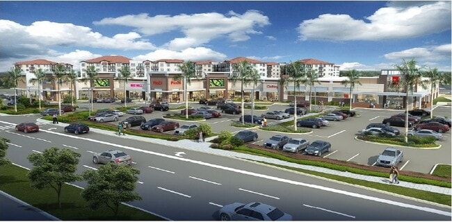
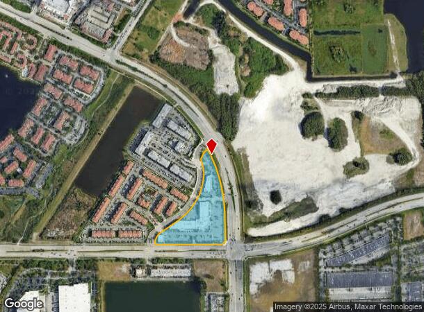
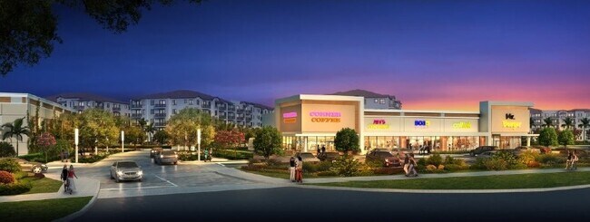
Property Record
2850 Red Rd, Miramar, FL 33025
NEARBY LISTINGS FOR SALE OR LEASE
Property Detail
2850 Red Rd
51-40-25-12-0012
Altman Development Miramar
Storebuilding
ALTMAN DEVELOPMENT MIRAMAR 183-232 B A POR OF TR A DESC AS:COMM AT MOST NLY COR OF SAID TR A,SELY ALG CUR 658.59 TO POB, CONT SELY 702.16,S 253.95,SW 48.70,W 49.10 ,N 2,W 40,S 2,W 590.93, N 16.62 TO P/C,NELY ALG CUR 113.65, NE 231.94 TO P/C, NELY ALG
AE
Broward
12011C0710J
Florida
2024
7.04 AC
2025
Southwest Broward
110348
South Florida
55,415 SF
Fort Lauderdale-Pompano Beach-Deerfield Beach, FL
DEMOGRAPHICS near 2850 Red Rd
1 Mile
3 Mile
5 Mile
2024 Total Population
16,682
171,660
416,549
2029 Population
16,790
169,249
408,193
Pop Growth 2024-2029
+ 0.65%
(1.40%)
(2.01%)
Average Age
35
41
40
2024 Total Households
6,116
61,655
138,775
HH Growth 2024-2029
+ 0.07%
(1.60%)
(2.33%)
Median Household Inc
$72,836
$59,830
$67,803
Avg Household Size
2.70
2.70
2.90
2024 Avg HH Vehicles
2.00
2.00
2.00
Median Home Value
$324,239
$298,699
$339,163
Median Year Built
1999
1990
1988
Nearby Places
Map Layers
Map Styles
 Street
 Aerial
- Restaurants
- Banks
- Shops
- Fitness
- Groceries
PUBLIC TRANSPORTATION
COMMUTER RAIL
Opa-Locka (Tri-County Commuter - South Florida Regional Transportation Authority (Tri-Rail))
DRIVE
WALK
Distance
Opa-Locka (Tri-County Commuter - South Florida Regional Transportation Authority (Tri-Rail))
15 min
8.2 mi
AIRPORT
Fort Lauderdale/Hollywood International
DRIVE
WALK
Distance
Fort Lauderdale/Hollywood International
25 min
16.5 mi
Miami International
DRIVE
WALK
Distance
Miami International
30 min
19.6 mi
Freight Ports
Port Everglades
DRIVE
WALK
Distance
Port Everglades
28 min
19.1 mi
SALE & LEASE HISTORY
LISTING DATE
SALE/LEASE

Apr 06, 2018
For Lease
Nearby Properties
Address
Land Use
TOTAL SIZE
Lot Size
Zoning
Address
Land Use
TOTAL SIZE
Lot Size
Zoning
1,913,667 SF
26.13 AC
(HD)
Address
Land Use
TOTAL SIZE
Lot Size
Zoning
598,209 SF
20 AC
PID
Address
Land Use
TOTAL SIZE
Lot Size
Zoning
685,369 SF
22.67 AC
RM2
Address
Land Use
TOTAL SIZE
Lot Size
Zoning
704,522 SF
43.09 AC
(R-MF)
Address
Land Use
TOTAL SIZE
Lot Size
Zoning
402,526 SF
39.92 AC
(PCD)
Address
Land Use
TOTAL SIZE
Lot Size
Zoning
368,107 SF
10.11 AC
ML
Address
Land Use
TOTAL SIZE
Lot Size
Zoning
1,589,724 SF
95.63 AC
7100
Address
Land Use
TOTAL SIZE
Lot Size
Zoning
490,929 SF
25.51 AC
RM3
Address
Land Use
TOTAL SIZE
Lot Size
Zoning
552,359 SF
16.73 AC
(MXD)
Address
Land Use
TOTAL SIZE
Lot Size
Zoning
436,707 SF
32.94 AC
RM3
Address
Land Use
TOTAL SIZE
Lot Size
Zoning
565,145 SF
91.77 AC
(B-3)
Address
Land Use
TOTAL SIZE
Lot Size
Zoning
954,839 SF
129.74 AC
(CF)
Address
Land Use
TOTAL SIZE
Lot Size
Zoning
424,864 SF
13.03 AC
(MXD)
Address
Land Use
TOTAL SIZE
Lot Size
Zoning
594,379 SF
11.05 AC
(MXD)
Address
Land Use
TOTAL SIZE
Lot Size
Zoning
420,648 SF
21.12 AC
(PUD)
Address
Land Use
TOTAL SIZE
Lot Size
Zoning
120,252 SF
6.85 AC
(HD)
Address
Land Use
TOTAL SIZE
Lot Size
Zoning
426,620 SF
17.69 AC
RM3
Address
Land Use
TOTAL SIZE
Lot Size
Zoning
344,589 SF
13.91 AC
ML
Address
Land Use
TOTAL SIZE
Lot Size
Zoning
359,351 SF
28.25 AC
RM3
Address
Land Use
TOTAL SIZE
Lot Size
Zoning
371,952 SF
13.41 AC
ML
Address
Land Use
TOTAL SIZE
Lot Size
Zoning
349,298 SF
23.67 AC
RM2
Address
Land Use
TOTAL SIZE
Lot Size
Zoning
454,092 SF
6.13 AC
(PD-SL)
Address
Land Use
TOTAL SIZE
Lot Size
Zoning
427,495 SF
18.15 AC
(R-MF)
Address
Land Use
TOTAL SIZE
Lot Size
Zoning
377,261 SF
14.92 AC
RM3
Address
Land Use
TOTAL SIZE
Lot Size
Zoning
375,246 SF
10.47 AC
(MXD)
Address
Land Use
TOTAL SIZE
Lot Size
Zoning
282,107 SF
26.59 AC
(R-MF)
Address
Land Use
TOTAL SIZE
Lot Size
Zoning
400,766 SF
16.51 AC
(PUD)
Address
Land Use
TOTAL SIZE
Lot Size
Zoning
330,030 SF
20.13 AC
(R-MF)
Address
Land Use
TOTAL SIZE
Lot Size
Zoning
353,215 SF
23.37 AC
(PUD)
Address
Land Use
TOTAL SIZE
Lot Size
Zoning
374,150 SF
4.29 AC
TND
The World's #1 Commercial Real Estate Marketplace
Connect with us
© 2025 CoStar Group
The information above has been obtained from sources believed reliable. While we do not doubt its accuracy we have not verified it and make no guarantee, warranty or representation about it. It is your responsibility to independently confirm its accuracy and completeness. Any projections, opinions, assumptions, or estimates used are for example only and do not represent the current or future performance of the property. The value of this transaction to you depends on tax and other factors which should be evaluated by your tax, financial, and legal advisors. You and your advisors should conduct a careful, independent investigation of the property to determine to your satisfaction the suitability of the property for your needs.