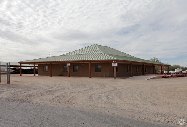
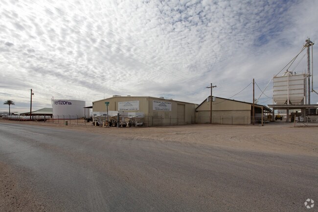
Property Record
2850 S Peart Rd, Casa Grande, AZ 85193

NEARBY LISTINGS FOR SALE OR LEASE
-
-
View all Casa Grande listings for sale on LoopNet.com
Property Detail
2850 S Peart Rd
505-33-001D
COMMENCING AT THE EAST QUARTER CORNER OF SECTION 33, TOWNSHIP 06 SOUTH, RANGE 06 EAST, THENCE SOUTH 841.14 FT TO THE POINT OF BEGI NNING THENCE SOUTH 493.45 FT THENCE WEST 307.95 FT THENCE NORTH 6 4.05 FT THENCE WEST 129.99 FT THENCE NORTH 420.77 FT
Warehouse
Pinal
X
Arizona
04021C1555E
6.47 AC
2024
Pinal County
2025
Phoenix
001406
Phoenix-Mesa-Scottsdale, AZ
17,040 SF
DEMOGRAPHICS near 2850 S Peart Rd
1 Mile
3 Mile
5 Mile
2024 Total Population
678
25,568
52,924
2029 Population
886
32,388
67,116
Pop Growth 2024-2029
+ 30.68%
+ 26.67%
+ 26.82%
Average Age
38
42
41
2024 Total Households
236
9,791
19,712
HH Growth 2024-2029
+ 29.66%
+ 26.01%
+ 26.31%
Median Household Inc
$49,633
$60,987
$62,230
Avg Household Size
2.70
2.50
2.60
2024 Avg HH Vehicles
2.00
2.00
2.00
Median Home Value
$125,833
$220,310
$234,464
Median Year Built
1994
2000
2000
Nearby Places
Map Layers
Map Styles
 Street
 Aerial
- Restaurants
- Banks
- Shops
- Fitness
- Groceries
Nearby Properties
Address
Land Use
TOTAL SIZE
Lot Size
Zoning
Address
Land Use
TOTAL SIZE
Lot Size
Zoning
48,433 SF
266.50 AC
Address
Land Use
TOTAL SIZE
Lot Size
Zoning
877,742 SF
125.20 AC
UNDESIGNAT
Address
Land Use
TOTAL SIZE
Lot Size
Zoning
216,795 SF
11.15 AC
Address
Land Use
TOTAL SIZE
Lot Size
Zoning
380,964 SF
36.62 AC
UNDESIGNAT
Address
Land Use
TOTAL SIZE
Lot Size
Zoning
131,386 SF
1.29 AC
UNDESIGNAT
Address
Land Use
TOTAL SIZE
Lot Size
Zoning
222,134 SF
24.14 AC
Address
Land Use
TOTAL SIZE
Lot Size
Zoning
196,294 SF
4.24 AC
Address
Land Use
TOTAL SIZE
Lot Size
Zoning
134,042 SF
15.68 AC
Address
Land Use
TOTAL SIZE
Lot Size
Zoning
131,275 SF
8.85 AC
Address
Land Use
TOTAL SIZE
Lot Size
Zoning
42,077 SF
3.37 AC
Address
Land Use
TOTAL SIZE
Lot Size
Zoning
125,899 SF
10.47 AC
Address
Land Use
TOTAL SIZE
Lot Size
Zoning
143,860 SF
14.88 AC
Address
Land Use
TOTAL SIZE
Lot Size
Zoning
121,969 SF
9.36 AC
Address
Land Use
TOTAL SIZE
Lot Size
Zoning
93,477 SF
4.22 AC
UNDESIGNAT
Address
Land Use
TOTAL SIZE
Lot Size
Zoning
111,066 SF
5.04 AC
UNDESIGNAT
Address
Land Use
TOTAL SIZE
Lot Size
Zoning
189,892 SF
39.82 AC
UNDESIGNAT
Address
Land Use
TOTAL SIZE
Lot Size
Zoning
137,735 SF
14.12 AC
Address
Land Use
TOTAL SIZE
Lot Size
Zoning
156,264 SF
10.70 AC
UNDESIGNAT
Address
Land Use
TOTAL SIZE
Lot Size
Zoning
0.12 AC
Address
Land Use
TOTAL SIZE
Lot Size
Zoning
74,433 SF
15.44 AC
UNDESIGNAT
Address
Land Use
TOTAL SIZE
Lot Size
Zoning
43,355 SF
5.91 AC
Address
Land Use
TOTAL SIZE
Lot Size
Zoning
320,334 SF
9.38 AC
Address
Land Use
TOTAL SIZE
Lot Size
Zoning
115,058 SF
13.41 AC
UNDESIGNAT
Address
Land Use
TOTAL SIZE
Lot Size
Zoning
41,824 SF
8.74 AC
Address
Land Use
TOTAL SIZE
Lot Size
Zoning
51,866 SF
5.88 AC
UNDESIGNAT
Address
Land Use
TOTAL SIZE
Lot Size
Zoning
28,115 SF
8.92 AC
Address
Land Use
TOTAL SIZE
Lot Size
Zoning
103,413 SF
7.74 AC
Address
Land Use
TOTAL SIZE
Lot Size
Zoning
53,952 SF
10 AC
Address
Land Use
TOTAL SIZE
Lot Size
Zoning
91,880 SF
13.63 AC
Address
Land Use
TOTAL SIZE
Lot Size
Zoning
39,422 SF
2.04 AC
The World's #1 Commercial Real Estate Marketplace
Connect with us
© 2026 CoStar Group
The information above has been obtained from sources believed reliable. While we do not doubt its accuracy we have not verified it and make no guarantee, warranty or representation about it. It is your responsibility to independently confirm its accuracy and completeness. Any projections, opinions, assumptions, or estimates used are for example only and do not represent the current or future performance of the property. The value of this transaction to you depends on tax and other factors which should be evaluated by your tax, financial, and legal advisors. You and your advisors should conduct a careful, independent investigation of the property to determine to your satisfaction the suitability of the property for your needs.