Property Record
2850 State Route 17K, Middletown, NY 10941
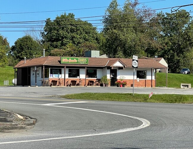

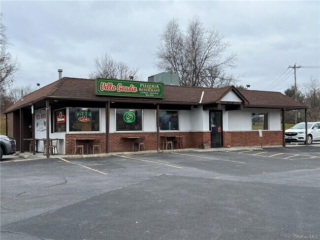
This Property Is For Sale
Property Detail
2850 State Route 17K
Kiryas Joel-Poughkeepsie-Newburgh, NY
ORANGE
332600-024-000-0001-050.400-0000
New York
Restaurantbuilding
50.40
B and X Area of moderate flood hazard, usually the area between the limits of the 100-year and 500-year floods.
0.58 AC
2024
Middletown
2025
Northern New Jersey
010902
NEARBY LISTINGS FOR SALE OR LEASE
-
-
View all Middletown listings for sale on LoopNet.com
DEMOGRAPHICS near 2850 State Route 17K
1 mile
3 mile
5 mile
2025 Total Population
417
5,800
25,801
2030 Population
415
5,895
26,036
Pop Growth 2025-2030
(0.48%)
+ 1.64%
+ 0.91%
Average Age
41
42
40
2025 Total Households
144
2,003
8,855
HH Growth 2025-2030
0.00%
+ 1.85%
+ 0.98%
Median Household Inc
$147,023
$120,601
$105,836
Avg Household Size
2.80
2.80
2.80
2025 Avg HH Vehicles
2.00
2.00
2.00
Median Home Value
$465,999
$433,139
$382,974
Median Year Built
1986
1984
1981
Nearby Places
Map Layers
Map Styles
 Street
 Aerial
Layers
 Traffic
 Biking
Places
Listings with unknown addresses are not visible on the map
- Restaurants
- Banks
- Shops
- Fitness
- Groceries
PUBLIC TRANSPORTATION
COMMUTER RAIL
Middletown New York (Bergen County/Port Jervis Line - NJ Transit Commuter Rail (NJ Transit), Main/Port Jervis Line - NJ Transit Commuter Rail (NJ Transit))
Drive
Walk
Distance
Middletown New York (Bergen County/Port Jervis Line - NJ Transit Commuter Rail (NJ Transit), Main/Port Jervis Line - NJ Transit Commuter Rail (NJ Transit))
15 min
7.9 mi
AIRPORT
New York Stewart International
Drive
Walk
Distance
New York Stewart International
25 min
16.5 mi
Nearby Properties
Address
Land Use
TOTAL SIZE
Lot Size
Zoning
Address
Land Use
TOTAL SIZE
Lot Size
Zoning
152.90 AC
Address
Land Use
TOTAL SIZE
Lot Size
Zoning
35.70 AC
R2
Address
Land Use
TOTAL SIZE
Lot Size
Zoning
20.90 AC
Address
Land Use
TOTAL SIZE
Lot Size
Zoning
1,856 SF
142.10 AC
RA07
Address
Land Use
TOTAL SIZE
Lot Size
Zoning
5,484 SF
129 AC
07
Address
Land Use
TOTAL SIZE
Lot Size
Zoning
18.80 AC
07
Address
Land Use
TOTAL SIZE
Lot Size
Zoning
34,268 SF
8.30 AC
B
Address
Land Use
TOTAL SIZE
Lot Size
Zoning
30,657 SF
135.40 AC
RA07
Address
Land Use
TOTAL SIZE
Lot Size
Zoning
20 AC
07
Address
Land Use
TOTAL SIZE
Lot Size
Zoning
Address
Land Use
TOTAL SIZE
Lot Size
Zoning
38.50 AC
07
Address
Land Use
TOTAL SIZE
Lot Size
Zoning
Address
Land Use
TOTAL SIZE
Lot Size
Zoning
19.90 AC
RA07
Address
Land Use
TOTAL SIZE
Lot Size
Zoning
20,056 SF
12.70 AC
B
Address
Land Use
TOTAL SIZE
Lot Size
Zoning
4,284 SF
13.80 AC
AR
Address
Land Use
TOTAL SIZE
Lot Size
Zoning
8,136 SF
35 AC
07
Address
Land Use
TOTAL SIZE
Lot Size
Zoning
73.60 AC
07
Address
Land Use
TOTAL SIZE
Lot Size
Zoning
Address
Land Use
TOTAL SIZE
Lot Size
Zoning
4,500 SF
10.90 AC
Address
Land Use
TOTAL SIZE
Lot Size
Zoning
17.80 AC
Address
Land Use
TOTAL SIZE
Lot Size
Zoning
5,180 SF
141.20 AC
RA
Address
Land Use
TOTAL SIZE
Lot Size
Zoning
Address
Land Use
TOTAL SIZE
Lot Size
Zoning
9,538 SF
1.90 AC
R2
Address
Land Use
TOTAL SIZE
Lot Size
Zoning
16,000 SF
14.70 AC
RA07
Address
Land Use
TOTAL SIZE
Lot Size
Zoning
6.50 AC
07
Address
Land Use
TOTAL SIZE
Lot Size
Zoning
3,166 SF
123 AC
RA
Address
Land Use
TOTAL SIZE
Lot Size
Zoning
18,930 SF
3 AC
07
Address
Land Use
TOTAL SIZE
Lot Size
Zoning
896 SF
1.80 AC
Address
Land Use
TOTAL SIZE
Lot Size
Zoning
4,912 SF
167.50 AC
RA07
Address
Land Use
TOTAL SIZE
Lot Size
Zoning
44.30 AC
The World's #1 Commercial Real Estate Marketplace
Connect with us
© 2026 CoStar Group
The information above has been obtained from sources believed reliable. While we do not doubt its accuracy we have not verified it and make no guarantee, warranty or representation about it. It is your responsibility to independently confirm its accuracy and completeness. Any projections, opinions, assumptions, or estimates used are for example only and do not represent the current or future performance of the property. The value of this transaction to you depends on tax and other factors which should be evaluated by your tax, financial, and legal advisors. You and your advisors should conduct a careful, independent investigation of the property to determine to your satisfaction the suitability of the property for your needs.