Property Record
2850 Unknown Dr, Fairfield, CA 94533

Property Detail
2850 Unknown Dr
Vallejo, CA
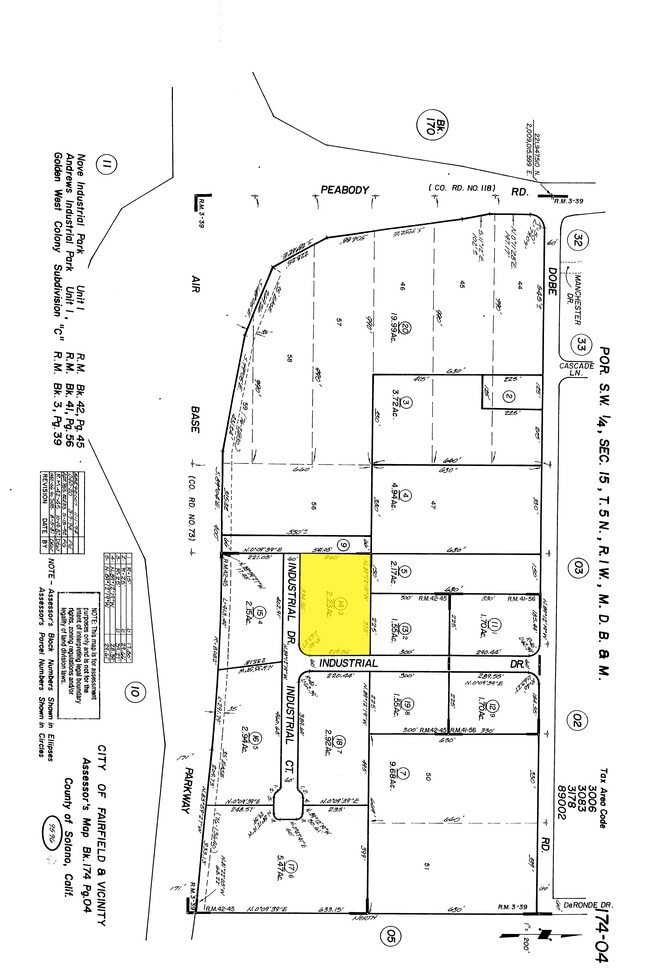
NOVE INDUSTRIAL PARK 1 SUB LOT 3
0174-040-140
SOLANO
Industrialacreage
California
C and X Area of minimal flood hazard, usually depicted on FIRMs as above the 500-year flood level.
3
2024
2.23 AC
2025
Fairfield/Suisun City
252606
North Bay/Santa Rosa
NEARBY LISTINGS FOR SALE OR LEASE
DEMOGRAPHICS near 2850 Unknown Dr
1 mile
3 mile
5 mile
2024 Total Population
3,122
44,973
148,206
2029 Population
3,152
44,765
146,883
Pop Growth 2024-2029
+ 0.96%
(0.46%)
(0.89%)
Average Age
30
37
38
2024 Total Households
850
13,623
46,737
HH Growth 2024-2029
+ 1.53%
(0.48%)
(1.00%)
Median Household Inc
$92,224
$101,901
$89,862
Avg Household Size
3.10
3.20
3.00
2024 Avg HH Vehicles
3.00
3.00
2.00
Median Home Value
$438,297
$496,834
$492,259
Median Year Built
1998
1988
1983
Nearby Places
Map Layers
Map Styles
 Street
 Aerial
Transit
 Traffic
 Biking
Places
Listings with unknown addresses are not visible on the map
- Restaurants
- Banks
- Shops
- Fitness
- Groceries
PUBLIC TRANSPORTATION
COMMUTER RAIL
Fairfield-Vacaville Amtrak Station (Capitol Corridor - Amtrak)
Drive
Walk
Distance
Fairfield-Vacaville Amtrak Station (Capitol Corridor - Amtrak)
4 min
1.5 mi
Suisun-Fairfield (Capitol Corridor - Capitol Corridor Joint Powers Authority)
Drive
Walk
Distance
Suisun-Fairfield (Capitol Corridor - Capitol Corridor Joint Powers Authority)
13 min
6.4 mi
Freight Ports
Port of Richmond
Drive
Walk
Distance
Port of Richmond
58 min
41.8 mi
SALE & LEASE HISTORY
LISTING DATE
SALE/LEASE

Dec 18, 2023
For Sale
Nearby Properties
Address
Land Use
TOTAL SIZE
Lot Size
Zoning
Address
Land Use
TOTAL SIZE
Lot Size
Zoning
999,999 SF
55.81 AC
LTD IND
Address
Land Use
TOTAL SIZE
Lot Size
Zoning
143,531 SF
13.45 AC
Address
Land Use
TOTAL SIZE
Lot Size
Zoning
144,972 SF
18.47 AC
Address
Land Use
TOTAL SIZE
Lot Size
Zoning
140,853 SF
25.35 AC
Address
Land Use
TOTAL SIZE
Lot Size
Zoning
177,945 SF
18.31 AC
Address
Land Use
TOTAL SIZE
Lot Size
Zoning
90,416 SF
6.03 AC
MULTIRE
Address
Land Use
TOTAL SIZE
Lot Size
Zoning
285,080 SF
15.35 AC
Address
Land Use
TOTAL SIZE
Lot Size
Zoning
44,950 SF
12.88 AC
MG 1/2
Address
Land Use
TOTAL SIZE
Lot Size
Zoning
185,266 SF
11.83 AC
Address
Land Use
TOTAL SIZE
Lot Size
Zoning
28,550 SF
4.31 AC
Address
Land Use
TOTAL SIZE
Lot Size
Zoning
4.84 AC
Address
Land Use
TOTAL SIZE
Lot Size
Zoning
313.44 AC
Address
Land Use
TOTAL SIZE
Lot Size
Zoning
24,374 SF
5.68 AC
Address
Land Use
TOTAL SIZE
Lot Size
Zoning
19.04 AC
Address
Land Use
TOTAL SIZE
Lot Size
Zoning
374,600 SF
15.78 AC
Address
Land Use
TOTAL SIZE
Lot Size
Zoning
42,350 SF
3.57 AC
Address
Land Use
TOTAL SIZE
Lot Size
Zoning
150,000 SF
7.57 AC
INDUSTRIAL
Address
Land Use
TOTAL SIZE
Lot Size
Zoning
39,000 SF
1.51 AC
Address
Land Use
TOTAL SIZE
Lot Size
Zoning
1.33 AC
Address
Land Use
TOTAL SIZE
Lot Size
Zoning
121,665 SF
4.69 AC
COMML
Address
Land Use
TOTAL SIZE
Lot Size
Zoning
192,096 SF
9.83 AC
Address
Land Use
TOTAL SIZE
Lot Size
Zoning
6.18 AC
Address
Land Use
TOTAL SIZE
Lot Size
Zoning
45,350 SF
9.88 AC
Address
Land Use
TOTAL SIZE
Lot Size
Zoning
0.98 AC
Address
Land Use
TOTAL SIZE
Lot Size
Zoning
35,216 SF
2.75 AC
Address
Land Use
TOTAL SIZE
Lot Size
Zoning
66,700 SF
7.22 AC
Address
Land Use
TOTAL SIZE
Lot Size
Zoning
59.51 AC
Address
Land Use
TOTAL SIZE
Lot Size
Zoning
46,352 SF
2.10 AC
Address
Land Use
TOTAL SIZE
Lot Size
Zoning
9.09 AC
RMD
Address
Land Use
TOTAL SIZE
Lot Size
Zoning
169.02 AC
The World's #1 Commercial Real Estate Marketplace
Connect with us
© 2026 CoStar Group
The information above has been obtained from sources believed reliable. While we do not doubt its accuracy we have not verified it and make no guarantee, warranty or representation about it. It is your responsibility to independently confirm its accuracy and completeness. Any projections, opinions, assumptions, or estimates used are for example only and do not represent the current or future performance of the property. The value of this transaction to you depends on tax and other factors which should be evaluated by your tax, financial, and legal advisors. You and your advisors should conduct a careful, independent investigation of the property to determine to your satisfaction the suitability of the property for your needs.