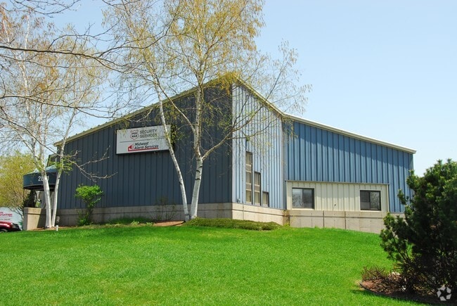
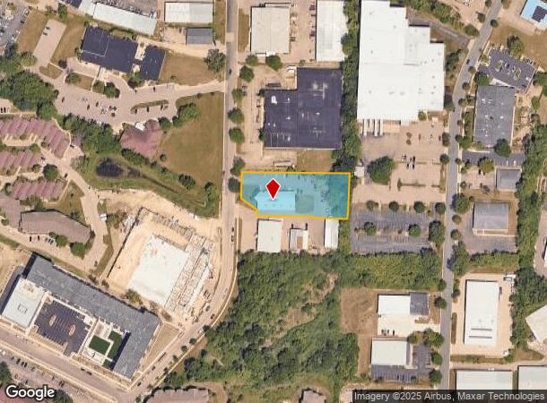
Property Record
2851 Index Rd, Fitchburg, WI 53713


NEARBY LISTINGS FOR SALE OR LEASE
Property Detail
2851 Index Rd
Madison, WI
Certified Surv Map 5861
0609-031-0031-6
PRT LOTS 2 & 3 CSM 5861 CS27/317&318 R12871/32&33 F/K/A MAPLE LAWN HEIGHTS COMME RCIAL PLAT PRT LOT 1 BEG SE COR SD LOT 2 TH N89DEG3117W 107.5 FT TH N0DEG2843 E 5.89 FT TH N89DEG3117W 182.28 FT TH N0DEG3730E 19.12 FT TH N52DEG4548W 62.29 FT T N0DEG37
Commercialnec
Dane
X
Wisconsin
55025C0419G
2,3
2024
1.05 AC
2024
S Central Madison
001405
Milwaukee/Madison
DEMOGRAPHICS near 2851 Index Rd
1 Mile
3 Mile
5 Mile
2024 Total Population
9,390
75,941
187,064
2029 Population
9,769
78,474
193,074
Pop Growth 2024-2029
+ 4.04%
+ 3.34%
+ 3.21%
Average Age
33
36
36
2024 Total Households
4,179
33,197
82,276
HH Growth 2024-2029
+ 4.24%
+ 3.54%
+ 3.49%
Median Household Inc
$41,401
$68,121
$64,250
Avg Household Size
2.20
2.20
2.10
2024 Avg HH Vehicles
1.00
2.00
1.00
Median Home Value
$223,362
$372,311
$359,815
Median Year Built
1984
1977
1975
Nearby Places
Map Layers
Map Styles
 Street
 Aerial
- Restaurants
- Banks
- Shops
- Fitness
- Groceries
PUBLIC TRANSPORTATION
AIRPORT
Dane County Regional/Truax Field
DRIVE
WALK
Distance
Dane County Regional/Truax Field
21 min
10.1 mi
Nearby Properties
Address
Land Use
TOTAL SIZE
Lot Size
Zoning
Address
Land Use
TOTAL SIZE
Lot Size
Zoning
8.42 AC
Address
Land Use
TOTAL SIZE
Lot Size
Zoning
21.49 AC
Address
Land Use
TOTAL SIZE
Lot Size
Zoning
169,224 SF
5.49 AC
CC-T
Address
Land Use
TOTAL SIZE
Lot Size
Zoning
460,603 SF
1.08 AC
PD
Address
Land Use
TOTAL SIZE
Lot Size
Zoning
18.97 AC
Address
Land Use
TOTAL SIZE
Lot Size
Zoning
230,268 SF
0.87 AC
UMX
Address
Land Use
TOTAL SIZE
Lot Size
Zoning
183,407 SF
2.71 AC
PD
Address
Land Use
TOTAL SIZE
Lot Size
Zoning
2.97 AC
Address
Land Use
TOTAL SIZE
Lot Size
Zoning
182,821 SF
1.19 AC
PD
Address
Land Use
TOTAL SIZE
Lot Size
Zoning
172,984 SF
1.59 AC
PD
Address
Land Use
TOTAL SIZE
Lot Size
Zoning
6.30 AC
Address
Land Use
TOTAL SIZE
Lot Size
Zoning
Address
Land Use
TOTAL SIZE
Lot Size
Zoning
14.47 AC
Address
Land Use
TOTAL SIZE
Lot Size
Zoning
24.62 AC
Address
Land Use
TOTAL SIZE
Lot Size
Zoning
3.21 AC
Address
Land Use
TOTAL SIZE
Lot Size
Zoning
404,794 SF
4.86 AC
CC-T
Address
Land Use
TOTAL SIZE
Lot Size
Zoning
234,075 SF
0.80 AC
UMX
Address
Land Use
TOTAL SIZE
Lot Size
Zoning
13.40 AC
Address
Land Use
TOTAL SIZE
Lot Size
Zoning
6.39 AC
Address
Land Use
TOTAL SIZE
Lot Size
Zoning
24,245 SF
2.23 AC
TSS
Address
Land Use
TOTAL SIZE
Lot Size
Zoning
4.22 AC
Address
Land Use
TOTAL SIZE
Lot Size
Zoning
180,552 SF
1.66 AC
PD
Address
Land Use
TOTAL SIZE
Lot Size
Zoning
Address
Land Use
TOTAL SIZE
Lot Size
Zoning
329,670 SF
11.12 AC
SR-V2
Address
Land Use
TOTAL SIZE
Lot Size
Zoning
4,992 SF
4.09 AC
SE
Address
Land Use
TOTAL SIZE
Lot Size
Zoning
156,167 SF
0.81 AC
PD
Address
Land Use
TOTAL SIZE
Lot Size
Zoning
9.97 AC
Address
Land Use
TOTAL SIZE
Lot Size
Zoning
19.21 AC
Address
Land Use
TOTAL SIZE
Lot Size
Zoning
121,671 SF
3.70 AC
PD
Address
Land Use
TOTAL SIZE
Lot Size
Zoning
12.03 AC
The World's #1 Commercial Real Estate Marketplace
Connect with us
© 2025 CoStar Group
The information above has been obtained from sources believed reliable. While we do not doubt its accuracy we have not verified it and make no guarantee, warranty or representation about it. It is your responsibility to independently confirm its accuracy and completeness. Any projections, opinions, assumptions, or estimates used are for example only and do not represent the current or future performance of the property. The value of this transaction to you depends on tax and other factors which should be evaluated by your tax, financial, and legal advisors. You and your advisors should conduct a careful, independent investigation of the property to determine to your satisfaction the suitability of the property for your needs.