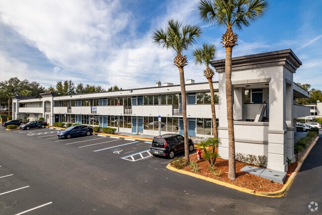
Property Record
2810 Maingate Village Cir, Kissimmee, FL 34747
Current Lease Availabilities
NEARBY LISTINGS FOR SALE OR LEASE
-
-
View all Kissimmee listings for lease on LoopNet.com
Property Detail
2810 Maingate Village Cir
Orlando
Osceola
Orlando-Kissimmee-Sanford, FL
Florida
11-25-27-4051-0001-COMM
15.23 AC
Condominium
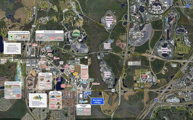
Disney
235,512 SF
DEMOGRAPHICS near 2810 Maingate Village Cir
1 Mile
3 Mile
5 Mile
2024 Total Population
2,506
26,135
61,005
2029 Population
3,284
32,615
75,669
Pop Growth 2024-2029
+ 31.05%
+ 24.79%
+ 24.04%
Average Age
35
38
38
2024 Total Households
889
10,028
23,645
HH Growth 2024-2029
+ 30.93%
+ 24.43%
+ 23.97%
Median Household Inc
$71,044
$72,775
$70,070
Avg Household Size
2.80
2.60
2.60
2024 Avg HH Vehicles
2.00
2.00
2.00
Median Home Value
$282,515
$370,829
$356,838
Median Year Built
2008
2004
2006
Nearby Places
- Restaurants
- Banks
- Shops
- Fitness
- Groceries
PUBLIC TRANSPORTATION
AIRPORT
Orlando International
DRIVE
WALK
Distance
Orlando International
33 min
22.3 mi
Freight Ports
Port of Tampa Bay
DRIVE
WALK
Distance
Port of Tampa Bay
81 min
66.3 mi
Nearby Properties
Address
Land Use
TOTAL SIZE
Lot Size
Zoning
Address
Land Use
TOTAL SIZE
Lot Size
Zoning
4,661,206 SF
277.42 AC
E
Address
Land Use
TOTAL SIZE
Lot Size
Zoning
386,104 SF
8.14 AC
Address
Land Use
TOTAL SIZE
Lot Size
Zoning
1,314,060 SF
32.08 AC
P-D
Address
Land Use
TOTAL SIZE
Lot Size
Zoning
1,956,707 SF
209.24 AC
RCID
Address
Land Use
TOTAL SIZE
Lot Size
Zoning
1,353,936 SF
523.88 AC
E
Address
Land Use
TOTAL SIZE
Lot Size
Zoning
1,980,310 SF
140.63 AC
H/R
Address
Land Use
TOTAL SIZE
Lot Size
Zoning
883,200 SF
75.26 AC
P-D
Address
Land Use
TOTAL SIZE
Lot Size
Zoning
1,305,920 SF
84.34 AC
U
Address
Land Use
TOTAL SIZE
Lot Size
Zoning
1,355,781 SF
119.30 AC
H/R
Address
Land Use
TOTAL SIZE
Lot Size
Zoning
874,488 SF
159.54 AC
H/R
Address
Land Use
TOTAL SIZE
Lot Size
Zoning
571,384 SF
249.40 AC
RCID
Address
Land Use
TOTAL SIZE
Lot Size
Zoning
42,558 SF
9.31 AC
Address
Land Use
TOTAL SIZE
Lot Size
Zoning
1,446,052 SF
64.06 AC
OPUD
Address
Land Use
TOTAL SIZE
Lot Size
Zoning
283,974 SF
3.23 AC
P-D
Address
Land Use
TOTAL SIZE
Lot Size
Zoning
676,113 SF
24.67 AC
H/R
Address
Land Use
TOTAL SIZE
Lot Size
Zoning
1 SF
3.14 AC
Address
Land Use
TOTAL SIZE
Lot Size
Zoning
331,691 SF
2.85 AC
H/R
Address
Land Use
TOTAL SIZE
Lot Size
Zoning
533,192 SF
70.52 AC
OPUD
Address
Land Use
TOTAL SIZE
Lot Size
Zoning
280,327 SF
16.27 AC
OCG
Address
Land Use
TOTAL SIZE
Lot Size
Zoning
55,980 SF
57.91 AC
C
Address
Land Use
TOTAL SIZE
Lot Size
Zoning
439,638 SF
28.93 AC
OPUD
Address
Land Use
TOTAL SIZE
Lot Size
Zoning
480,142 SF
29.57 AC
OPD
Address
Land Use
TOTAL SIZE
Lot Size
Zoning
597,078 SF
51.33 AC
Address
Land Use
TOTAL SIZE
Lot Size
Zoning
412,934 SF
11.96 AC
Address
Land Use
TOTAL SIZE
Lot Size
Zoning
363,694 SF
17.65 AC
Address
Land Use
TOTAL SIZE
Lot Size
Zoning
355,791 SF
28.19 AC
OPD
Address
Land Use
TOTAL SIZE
Lot Size
Zoning
358,576 SF
27.34 AC
OPD
Address
Land Use
TOTAL SIZE
Lot Size
Zoning
418,368 SF
12.66 AC
Address
Land Use
TOTAL SIZE
Lot Size
Zoning
342,019 SF
23 AC
OCG
Address
Land Use
TOTAL SIZE
Lot Size
Zoning
315,823 SF
14.41 AC
OPD
The World's #1 Commercial Real Estate Marketplace
Connect with us
© 2025 CoStar Group
The information above has been obtained from sources believed reliable. While we do not doubt its accuracy we have not verified it and make no guarantee, warranty or representation about it. It is your responsibility to independently confirm its accuracy and completeness. Any projections, opinions, assumptions, or estimates used are for example only and do not represent the current or future performance of the property. The value of this transaction to you depends on tax and other factors which should be evaluated by your tax, financial, and legal advisors. You and your advisors should conduct a careful, independent investigation of the property to determine to your satisfaction the suitability of the property for your needs.