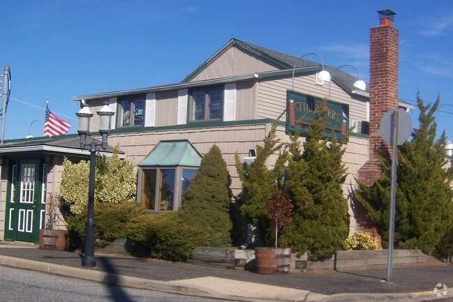
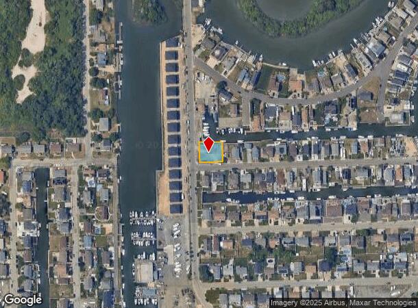
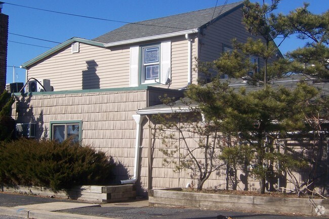
Property Record
2851 Ocean Ave, Seaford, NY 11783

NEARBY LISTINGS FOR SALE OR LEASE
Property Detail
2851 Ocean Ave
2089-63-061-00-0001-0
TOWN #1 SCH DIST 006
Portharbor
Nassau
AE
New York
36059C0263G
1
2025
0.20 AC
2025
Southeast Nassau
416100
Long Island (New York)
3,255 SF
Nassau County-Suffolk County, NY
DEMOGRAPHICS near 2851 Ocean Ave
1 Mile
3 Mile
5 Mile
2024 Total Population
6,986
88,498
266,980
2029 Population
6,864
86,908
261,913
Pop Growth 2024-2029
(1.75%)
(1.80%)
(1.90%)
Average Age
42
42
42
2024 Total Households
2,412
29,691
88,139
HH Growth 2024-2029
(1.87%)
(1.95%)
(2.03%)
Median Household Inc
$124,361
$157,669
$134,866
Avg Household Size
2.90
2.90
2.90
2024 Avg HH Vehicles
2.00
2.00
2.00
Median Home Value
$689,744
$703,366
$633,895
Median Year Built
1962
1956
1955
Nearby Places
- Restaurants
- Banks
- Shops
- Fitness
- Groceries
PUBLIC TRANSPORTATION
COMMUTER RAIL
Wantagh Station (Babylon Branch - Long Island Rail Road)
DRIVE
WALK
Distance
Wantagh Station (Babylon Branch - Long Island Rail Road)
7 min
2.4 mi
Seaford Station (Babylon Branch - Long Island Rail Road)
DRIVE
WALK
Distance
Seaford Station (Babylon Branch - Long Island Rail Road)
8 min
2.5 mi
AIRPORT
John F Kennedy International
DRIVE
WALK
Distance
John F Kennedy International
31 min
19.3 mi
LaGuardia
DRIVE
WALK
Distance
LaGuardia
42 min
26.2 mi
Long Island MacArthur
DRIVE
WALK
Distance
Long Island MacArthur
41 min
26.8 mi
Freight Ports
NY - Red Hook Container Terminal
DRIVE
WALK
Distance
NY - Red Hook Container Terminal
52 min
30.7 mi
Nearby Properties
Address
Land Use
TOTAL SIZE
Lot Size
Zoning
Address
Land Use
TOTAL SIZE
Lot Size
Zoning
49,840 SF
729.60 AC
Address
Land Use
TOTAL SIZE
Lot Size
Zoning
20,080 SF
91.79 AC
Address
Land Use
TOTAL SIZE
Lot Size
Zoning
105,868 SF
198 AC
Address
Land Use
TOTAL SIZE
Lot Size
Zoning
4,356 SF
246.70 AC
Address
Land Use
TOTAL SIZE
Lot Size
Zoning
182.25 AC
Address
Land Use
TOTAL SIZE
Lot Size
Zoning
173.70 AC
Address
Land Use
TOTAL SIZE
Lot Size
Zoning
Address
Land Use
TOTAL SIZE
Lot Size
Zoning
20,000 SF
123.34 AC
Address
Land Use
TOTAL SIZE
Lot Size
Zoning
147.58 AC
Address
Land Use
TOTAL SIZE
Lot Size
Zoning
119,692 SF
24.59 AC
Address
Land Use
TOTAL SIZE
Lot Size
Zoning
95.90 AC
Address
Land Use
TOTAL SIZE
Lot Size
Zoning
3,900 SF
52.04 AC
Address
Land Use
TOTAL SIZE
Lot Size
Zoning
57,874 SF
21 AC
Address
Land Use
TOTAL SIZE
Lot Size
Zoning
9,515 SF
121.73 AC
Address
Land Use
TOTAL SIZE
Lot Size
Zoning
17,305 SF
51.61 AC
Address
Land Use
TOTAL SIZE
Lot Size
Zoning
81.18 AC
Address
Land Use
TOTAL SIZE
Lot Size
Zoning
101.71 AC
Address
Land Use
TOTAL SIZE
Lot Size
Zoning
1,500 SF
125.69 AC
Address
Land Use
TOTAL SIZE
Lot Size
Zoning
67,408 SF
66.13 AC
Address
Land Use
TOTAL SIZE
Lot Size
Zoning
120,000 SF
28.96 AC
Address
Land Use
TOTAL SIZE
Lot Size
Zoning
80,895 SF
26.22 AC
Address
Land Use
TOTAL SIZE
Lot Size
Zoning
45.91 AC
Address
Land Use
TOTAL SIZE
Lot Size
Zoning
2,145 SF
52.37 AC
Address
Land Use
TOTAL SIZE
Lot Size
Zoning
1,181 SF
25.01 AC
Address
Land Use
TOTAL SIZE
Lot Size
Zoning
81 AC
Address
Land Use
TOTAL SIZE
Lot Size
Zoning
68.64 AC
Address
Land Use
TOTAL SIZE
Lot Size
Zoning
65.74 AC
Address
Land Use
TOTAL SIZE
Lot Size
Zoning
112,053 SF
16.13 AC
Address
Land Use
TOTAL SIZE
Lot Size
Zoning
65,102 SF
27.67 AC
Address
Land Use
TOTAL SIZE
Lot Size
Zoning
37.57 AC
The World's #1 Commercial Real Estate Marketplace
Connect with us
© 2025 CoStar Group
The information above has been obtained from sources believed reliable. While we do not doubt its accuracy we have not verified it and make no guarantee, warranty or representation about it. It is your responsibility to independently confirm its accuracy and completeness. Any projections, opinions, assumptions, or estimates used are for example only and do not represent the current or future performance of the property. The value of this transaction to you depends on tax and other factors which should be evaluated by your tax, financial, and legal advisors. You and your advisors should conduct a careful, independent investigation of the property to determine to your satisfaction the suitability of the property for your needs.