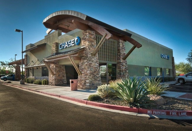
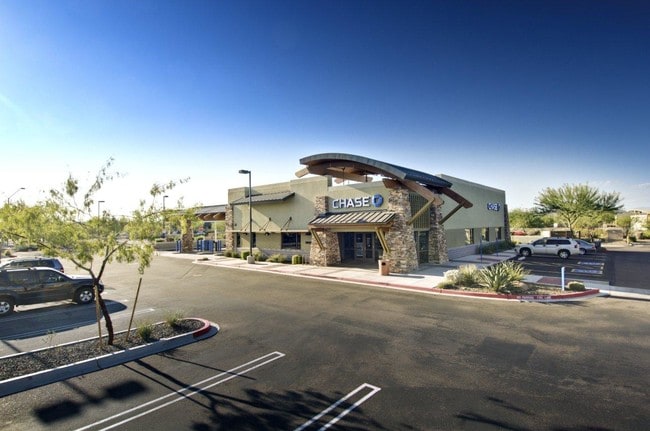
Property Record
28523 N El Mirage Rd, Peoria, AZ 85383

NEARBY LISTINGS FOR SALE OR LEASE
Property Detail
28523 N El Mirage Rd
Phoenix-Mesa-Scottsdale, AZ
Vistancia Retail Subdivision Parcel D9
503-99-830
VISTANCIA RETAIL SUBDIVISION PARCEL D9 MCR 913-21
Financialbuilding
Maricopa
X
Arizona
04013C1230L
3
2025
0.97 AC
2025
Surprise/North Peoria
040536
Phoenix
4,989 SF
DEMOGRAPHICS near 28523 N El Mirage Rd
1 Mile
3 Mile
5 Mile
2024 Total Population
6,113
33,058
74,747
2029 Population
6,743
36,645
82,038
Pop Growth 2024-2029
+ 10.31%
+ 10.85%
+ 9.75%
Average Age
46
43
44
2024 Total Households
2,331
12,002
27,733
HH Growth 2024-2029
+ 10.51%
+ 11.16%
+ 9.93%
Median Household Inc
$106,552
$114,828
$108,074
Avg Household Size
2.60
2.70
2.70
2024 Avg HH Vehicles
2.00
2.00
2.00
Median Home Value
$561,949
$492,460
$463,127
Median Year Built
2008
2010
2007
Nearby Places
Map Layers
Map Styles
 Street
 Aerial
- Restaurants
- Banks
- Shops
- Fitness
- Groceries
PUBLIC TRANSPORTATION
AIRPORT
Phoenix Sky Harbor International
DRIVE
WALK
Distance
Phoenix Sky Harbor International
58 min
42.9 mi
Nearby Properties
Address
Land Use
TOTAL SIZE
Lot Size
Zoning
Address
Land Use
TOTAL SIZE
Lot Size
Zoning
Address
Land Use
TOTAL SIZE
Lot Size
Zoning
110,752 SF
16.07 AC
PAD
Address
Land Use
TOTAL SIZE
Lot Size
Zoning
120,691 SF
16.33 AC
PAD
Address
Land Use
TOTAL SIZE
Lot Size
Zoning
252,143 SF
13.24 AC
Address
Land Use
TOTAL SIZE
Lot Size
Zoning
192,849 SF
19.09 AC
R3
Address
Land Use
TOTAL SIZE
Lot Size
Zoning
394,394 SF
15.24 AC
PAD
Address
Land Use
TOTAL SIZE
Lot Size
Zoning
118,893 SF
5.07 AC
C3
Address
Land Use
TOTAL SIZE
Lot Size
Zoning
28,034 SF
18.35 AC
PCD
Address
Land Use
TOTAL SIZE
Lot Size
Zoning
1,522 SF
20.43 AC
C2
Address
Land Use
TOTAL SIZE
Lot Size
Zoning
57,888 SF
4.65 AC
PAD
Address
Land Use
TOTAL SIZE
Lot Size
Zoning
Address
Land Use
TOTAL SIZE
Lot Size
Zoning
22,755 SF
2.63 AC
PCD
Address
Land Use
TOTAL SIZE
Lot Size
Zoning
16,454 SF
6.55 AC
C-C
Address
Land Use
TOTAL SIZE
Lot Size
Zoning
11,578 SF
19.90 AC
Address
Land Use
TOTAL SIZE
Lot Size
Zoning
12,864 SF
7.28 AC
Address
Land Use
TOTAL SIZE
Lot Size
Zoning
18.96 AC
R-43
Address
Land Use
TOTAL SIZE
Lot Size
Zoning
10,001 SF
2.15 AC
PCD
Address
Land Use
TOTAL SIZE
Lot Size
Zoning
12,207 SF
47.06 AC
PAD
Address
Land Use
TOTAL SIZE
Lot Size
Zoning
14,722 SF
1.51 AC
PAD
Address
Land Use
TOTAL SIZE
Lot Size
Zoning
213.80 AC
Address
Land Use
TOTAL SIZE
Lot Size
Zoning
1.28 AC
Address
Land Use
TOTAL SIZE
Lot Size
Zoning
6,840 SF
1.33 AC
PCD
Address
Land Use
TOTAL SIZE
Lot Size
Zoning
Address
Land Use
TOTAL SIZE
Lot Size
Zoning
Address
Land Use
TOTAL SIZE
Lot Size
Zoning
The World's #1 Commercial Real Estate Marketplace
Connect with us
© 2026 CoStar Group
The information above has been obtained from sources believed reliable. While we do not doubt its accuracy we have not verified it and make no guarantee, warranty or representation about it. It is your responsibility to independently confirm its accuracy and completeness. Any projections, opinions, assumptions, or estimates used are for example only and do not represent the current or future performance of the property. The value of this transaction to you depends on tax and other factors which should be evaluated by your tax, financial, and legal advisors. You and your advisors should conduct a careful, independent investigation of the property to determine to your satisfaction the suitability of the property for your needs.