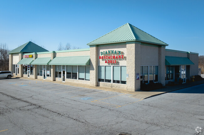
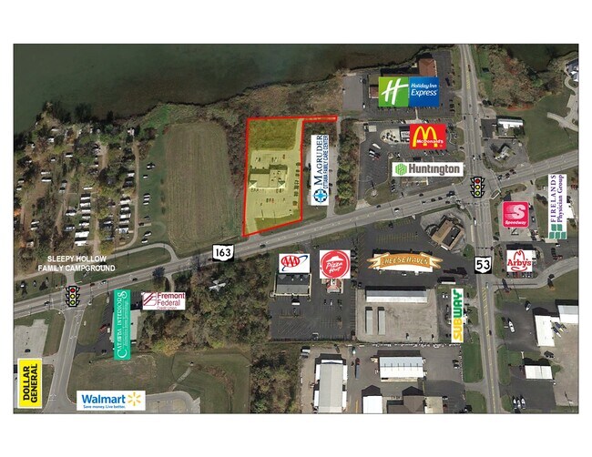
Property Record
2853 E East Harbor Rd, Port Clinton, OH 43452
NEARBY LISTINGS FOR SALE OR LEASE
-
-
View all Port Clinton listings for sale on LoopNet.com
Property Detail
2853 E East Harbor Rd
020-0781910361000
S35 T07 R17 PT NW 1/4
Stripcommercialcenter
Ottawa
AE
Ohio
39123C0165D
1.41 AC
2024
Ottawa County
2024
Toledo
051201
Port Clinton, OH
9,120 SF
DEMOGRAPHICS near 2853 E East Harbor Rd
1 Mile
3 Mile
5 Mile
2024 Total Population
716
6,702
16,764
2029 Population
716
6,944
17,121
Pop Growth 2024-2029
0.00%
+ 3.61%
+ 2.13%
Average Age
52
51
49
2024 Total Households
340
3,179
7,837
HH Growth 2024-2029
(0.59%)
+ 3.11%
+ 1.81%
Median Household Inc
$63,750
$69,721
$61,597
Avg Household Size
2.00
2.00
2.10
2024 Avg HH Vehicles
2.00
2.00
2.00
Median Home Value
$238,392
$246,544
$210,853
Median Year Built
1972
1981
1976
Nearby Places
Map Layers
Map Styles
 Street
 Aerial
- Restaurants
- Banks
- Shops
- Fitness
- Groceries
SALE & LEASE HISTORY
LISTING DATE
SALE/LEASE

Jun 07, 2022
For Sale
Jan 31, 2018
For Lease
Nearby Properties
Address
Land Use
TOTAL SIZE
Lot Size
Zoning
Address
Land Use
TOTAL SIZE
Lot Size
Zoning
2,128 SF
11.30 AC
Address
Land Use
TOTAL SIZE
Lot Size
Zoning
1,296 SF
1,284 AC
Address
Land Use
TOTAL SIZE
Lot Size
Zoning
912 SF
33.06 AC
Address
Land Use
TOTAL SIZE
Lot Size
Zoning
196,122 SF
24.71 AC
Address
Land Use
TOTAL SIZE
Lot Size
Zoning
5,472 SF
303.61 AC
Address
Land Use
TOTAL SIZE
Lot Size
Zoning
22,947 SF
4.94 AC
Address
Land Use
TOTAL SIZE
Lot Size
Zoning
62,149 SF
14.85 AC
Address
Land Use
TOTAL SIZE
Lot Size
Zoning
39,130 SF
6.70 AC
Address
Land Use
TOTAL SIZE
Lot Size
Zoning
58,090 SF
9.32 AC
Address
Land Use
TOTAL SIZE
Lot Size
Zoning
2,832 SF
65 AC
Address
Land Use
TOTAL SIZE
Lot Size
Zoning
31,228 SF
3.12 AC
Address
Land Use
TOTAL SIZE
Lot Size
Zoning
26,996 SF
2.85 AC
Address
Land Use
TOTAL SIZE
Lot Size
Zoning
55,190 SF
2.72 AC
Address
Land Use
TOTAL SIZE
Lot Size
Zoning
20,550 SF
7.56 AC
Address
Land Use
TOTAL SIZE
Lot Size
Zoning
52,493 SF
8.26 AC
Address
Land Use
TOTAL SIZE
Lot Size
Zoning
4,900 SF
15.52 AC
Address
Land Use
TOTAL SIZE
Lot Size
Zoning
15,722 SF
5 AC
Address
Land Use
TOTAL SIZE
Lot Size
Zoning
6,000 SF
11.72 AC
Address
Land Use
TOTAL SIZE
Lot Size
Zoning
Address
Land Use
TOTAL SIZE
Lot Size
Zoning
3,156 SF
0.95 AC
Address
Land Use
TOTAL SIZE
Lot Size
Zoning
2,760 SF
42.24 AC
Address
Land Use
TOTAL SIZE
Lot Size
Zoning
9,928 SF
4.19 AC
Address
Land Use
TOTAL SIZE
Lot Size
Zoning
53,330 SF
4.90 AC
Address
Land Use
TOTAL SIZE
Lot Size
Zoning
Address
Land Use
TOTAL SIZE
Lot Size
Zoning
30,942 SF
2.41 AC
Address
Land Use
TOTAL SIZE
Lot Size
Zoning
Address
Land Use
TOTAL SIZE
Lot Size
Zoning
7,329 SF
86.82 AC
Address
Land Use
TOTAL SIZE
Lot Size
Zoning
25,476 SF
1.03 AC
Address
Land Use
TOTAL SIZE
Lot Size
Zoning
24,345 SF
1.97 AC
Address
Land Use
TOTAL SIZE
Lot Size
Zoning
27.94 AC
The World's #1 Commercial Real Estate Marketplace
Connect with us
© 2025 CoStar Group
The information above has been obtained from sources believed reliable. While we do not doubt its accuracy we have not verified it and make no guarantee, warranty or representation about it. It is your responsibility to independently confirm its accuracy and completeness. Any projections, opinions, assumptions, or estimates used are for example only and do not represent the current or future performance of the property. The value of this transaction to you depends on tax and other factors which should be evaluated by your tax, financial, and legal advisors. You and your advisors should conduct a careful, independent investigation of the property to determine to your satisfaction the suitability of the property for your needs.