No Photo
Property Record
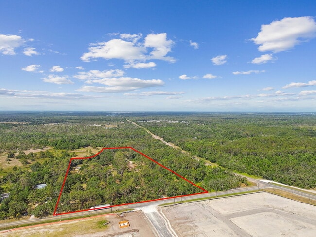
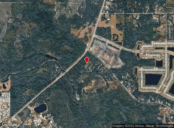
2853 Saffold Rd, Wimauma, FL 33598

NEARBY LISTINGS FOR SALE OR LEASE
-
-
View all Wimauma listings for sale on LoopNet.com
Property Detail
2853 Saffold Rd
Tampa-St. Petersburg-Clearwater, FL
Unplatted
U-30-32-20-ZZZ-000003-26540.0
COM AT NW COR OF NW 1/4 RUN S 1590.89 FT N 48 DEG 51 MIN 40 SEC E 423.79 FT S 41 DEG 08 MIN 20 SEC E 165.27 FT TO POB THN N 44 DEG 06 MIN 26 SEC E 1026.22 FT TO SWLY R/W OF DUG CREEK RD RUN S 47 DEG 29 MIN 50 SEC E 250 FT S 44 DEG 06 MIN 26 SEC W 335
Residentialacreage
Hillsborough
AE
Florida
12081C0065F
26540
2023
5.15 AC
2024
Eastern Outlying
013914
Tampa/St Petersburg
888 SF
DEMOGRAPHICS near 2853 Saffold Rd
1 Mile
3 Mile
5 Mile
2024 Total Population
1,274
25,641
60,690
2029 Population
1,500
30,378
72,431
Pop Growth 2024-2029
+ 17.74%
+ 18.47%
+ 19.35%
Average Age
39
60
53
2024 Total Households
394
12,786
25,868
HH Growth 2024-2029
+ 17.77%
+ 19.11%
+ 19.57%
Median Household Inc
$77,143
$50,496
$61,626
Avg Household Size
3.00
1.90
2.20
2024 Avg HH Vehicles
2.00
1.00
2.00
Median Home Value
$360,416
$229,202
$246,667
Median Year Built
2000
1996
2001
Nearby Places
Map Layers
Map Styles
 Street
 Aerial
- Restaurants
- Banks
- Shops
- Fitness
- Groceries
PUBLIC TRANSPORTATION
AIRPORT
Sarasota/Bradenton International
DRIVE
WALK
Distance
Sarasota/Bradenton International
47 min
30.0 mi
Tampa International
DRIVE
WALK
Distance
Tampa International
51 min
34.6 mi
St Pete-Clearwater International
DRIVE
WALK
Distance
St Pete-Clearwater International
65 min
46.6 mi
Freight Ports
Port Manatee
DRIVE
WALK
Distance
Port Manatee
27 min
17.7 mi
Nearby Properties
Address
Land Use
TOTAL SIZE
Lot Size
Zoning
Address
Land Use
TOTAL SIZE
Lot Size
Zoning
365,695 SF
17.84 AC
PD-MU
Address
Land Use
TOTAL SIZE
Lot Size
Zoning
4,979 SF
1,480.87 AC
PD
Address
Land Use
TOTAL SIZE
Lot Size
Zoning
295,588 SF
10.80 AC
PD-MU
Address
Land Use
TOTAL SIZE
Lot Size
Zoning
144,868 SF
17.10 AC
PD
Address
Land Use
TOTAL SIZE
Lot Size
Zoning
75,710 SF
10.24 AC
PD
Address
Land Use
TOTAL SIZE
Lot Size
Zoning
100,134 SF
10.45 AC
PD
Address
Land Use
TOTAL SIZE
Lot Size
Zoning
172.60 AC
PD
Address
Land Use
TOTAL SIZE
Lot Size
Zoning
62,648 SF
19.54 AC
AR
Address
Land Use
TOTAL SIZE
Lot Size
Zoning
32,120 SF
3.32 AC
PD
Address
Land Use
TOTAL SIZE
Lot Size
Zoning
35,246 SF
6.43 AC
RSC-6
Address
Land Use
TOTAL SIZE
Lot Size
Zoning
52,776 SF
213.10 AC
PD-MU
Address
Land Use
TOTAL SIZE
Lot Size
Zoning
53,580 SF
12.07 AC
PD-MU
Address
Land Use
TOTAL SIZE
Lot Size
Zoning
38,547 SF
26.88 AC
AS-1
Address
Land Use
TOTAL SIZE
Lot Size
Zoning
4,564 SF
15.53 AC
PD
Address
Land Use
TOTAL SIZE
Lot Size
Zoning
291.65 AC
AR
Address
Land Use
TOTAL SIZE
Lot Size
Zoning
370.62 AC
AR
Address
Land Use
TOTAL SIZE
Lot Size
Zoning
1,620 SF
224.25 AC
PD
Address
Land Use
TOTAL SIZE
Lot Size
Zoning
79.55 AC
PD
Address
Land Use
TOTAL SIZE
Lot Size
Zoning
22,733 SF
156.25 AC
PD
Address
Land Use
TOTAL SIZE
Lot Size
Zoning
27,124 SF
2.99 AC
PD-MU
Address
Land Use
TOTAL SIZE
Lot Size
Zoning
26,274 SF
1.42 AC
PD-MU
Address
Land Use
TOTAL SIZE
Lot Size
Zoning
25,568 SF
2.96 AC
PD-MU
Address
Land Use
TOTAL SIZE
Lot Size
Zoning
236.20 AC
AR
Address
Land Use
TOTAL SIZE
Lot Size
Zoning
20,022 SF
2.29 AC
CG
Address
Land Use
TOTAL SIZE
Lot Size
Zoning
6,179 SF
1.76 AC
PD
Address
Land Use
TOTAL SIZE
Lot Size
Zoning
196.30 AC
AR
Address
Land Use
TOTAL SIZE
Lot Size
Zoning
15,606 SF
1.54 AC
CG
Address
Land Use
TOTAL SIZE
Lot Size
Zoning
43,536 SF
2.88 AC
CG
Address
Land Use
TOTAL SIZE
Lot Size
Zoning
145.29 AC
PD
The World's #1 Commercial Real Estate Marketplace
Connect with us
© 2026 CoStar Group
The information above has been obtained from sources believed reliable. While we do not doubt its accuracy we have not verified it and make no guarantee, warranty or representation about it. It is your responsibility to independently confirm its accuracy and completeness. Any projections, opinions, assumptions, or estimates used are for example only and do not represent the current or future performance of the property. The value of this transaction to you depends on tax and other factors which should be evaluated by your tax, financial, and legal advisors. You and your advisors should conduct a careful, independent investigation of the property to determine to your satisfaction the suitability of the property for your needs.