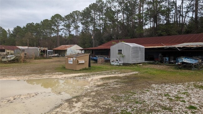
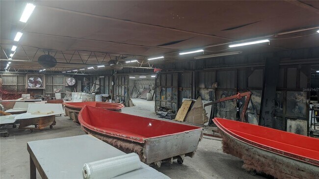
Property Record
2856 Ne 187Th St, Starke, FL 32091
NEARBY LISTINGS FOR SALE OR LEASE
-
-
View all Starke listings for sale on LoopNet.com
Property Detail
2856 Ne 187Th St
02094-0-00102
10 6S 22 COM AT THE INT OF THE NLY BNDY OF NE 185TH ST & THE ELY BNDY OF SR 200 (US 301), THENCE N17*0704E 659.44, THENCE N89*3045E 894.12 TO THE WLY BNDY CSX R/R, N16*2950E 455.66 TO NLY BNDY OF 187TH ST FOR POB. N89*5607W 327.90 N16*5848E 219.05, T
Lightindustrial
Bradford
X
Florida
12007C0205F
12
2025
1.33 AC
2025
Florida Central North Area
000400
Other Market Areas
8,533 SF
DEMOGRAPHICS near 2856 Ne 187Th St
1 Mile
3 Mile
5 Mile
2024 Total Population
444
5,269
14,259
2029 Population
456
5,486
14,806
Pop Growth 2024-2029
+ 2.70%
+ 4.12%
+ 3.84%
Average Age
41
41
41
2024 Total Households
153
1,934
5,188
HH Growth 2024-2029
+ 3.27%
+ 3.67%
+ 3.70%
Median Household Inc
$41,250
$43,004
$47,822
Avg Household Size
2.60
2.60
2.50
2024 Avg HH Vehicles
2.00
2.00
2.00
Median Home Value
$158,333
$149,115
$137,841
Median Year Built
1984
1986
1983
Nearby Places
Map Layers
Map Styles
 Street
 Aerial
- Restaurants
- Banks
- Shops
- Fitness
- Groceries
PUBLIC TRANSPORTATION
AIRPORT
Gainesville Regional
DRIVE
WALK
Distance
Gainesville Regional
40 min
28.0 mi
Freight Ports
Jacksonville Port
DRIVE
WALK
Distance
Jacksonville Port
60 min
45.8 mi
SALE & LEASE HISTORY
LISTING DATE
SALE/LEASE

Feb 23, 2024
For Sale
Nearby Properties
Address
Land Use
TOTAL SIZE
Lot Size
Zoning
Address
Land Use
TOTAL SIZE
Lot Size
Zoning
96,617 SF
11 AC
Address
Land Use
TOTAL SIZE
Lot Size
Zoning
119,949 SF
5.50 AC
Address
Land Use
TOTAL SIZE
Lot Size
Zoning
35,032 SF
8.75 AC
Address
Land Use
TOTAL SIZE
Lot Size
Zoning
30,963 SF
7.47 AC
Address
Land Use
TOTAL SIZE
Lot Size
Zoning
111,635 SF
44.63 AC
Address
Land Use
TOTAL SIZE
Lot Size
Zoning
29,120 SF
3.26 AC
Address
Land Use
TOTAL SIZE
Lot Size
Zoning
63.28 AC
Address
Land Use
TOTAL SIZE
Lot Size
Zoning
35,950 SF
2.76 AC
Address
Land Use
TOTAL SIZE
Lot Size
Zoning
14,806 SF
6.80 AC
Address
Land Use
TOTAL SIZE
Lot Size
Zoning
16,890 SF
12.64 AC
Address
Land Use
TOTAL SIZE
Lot Size
Zoning
15,926 SF
1.41 AC
Address
Land Use
TOTAL SIZE
Lot Size
Zoning
23,220 SF
2.41 AC
Address
Land Use
TOTAL SIZE
Lot Size
Zoning
33,282 SF
20 AC
Address
Land Use
TOTAL SIZE
Lot Size
Zoning
18,480 SF
10.83 AC
Address
Land Use
TOTAL SIZE
Lot Size
Zoning
49,871 SF
3 AC
Address
Land Use
TOTAL SIZE
Lot Size
Zoning
27,176 SF
13.75 AC
Address
Land Use
TOTAL SIZE
Lot Size
Zoning
15,040 SF
0.68 AC
Address
Land Use
TOTAL SIZE
Lot Size
Zoning
31,132 SF
4 AC
Address
Land Use
TOTAL SIZE
Lot Size
Zoning
370 AC
Address
Land Use
TOTAL SIZE
Lot Size
Zoning
9,576 SF
2.17 AC
Address
Land Use
TOTAL SIZE
Lot Size
Zoning
315.32 AC
Address
Land Use
TOTAL SIZE
Lot Size
Zoning
34,506 SF
9 AC
Address
Land Use
TOTAL SIZE
Lot Size
Zoning
10,545 SF
40 AC
Address
Land Use
TOTAL SIZE
Lot Size
Zoning
13,828 SF
5.95 AC
Address
Land Use
TOTAL SIZE
Lot Size
Zoning
29,942 SF
4.57 AC
Address
Land Use
TOTAL SIZE
Lot Size
Zoning
10,201 SF
6.75 AC
Address
Land Use
TOTAL SIZE
Lot Size
Zoning
321.95 AC
Address
Land Use
TOTAL SIZE
Lot Size
Zoning
320 AC
Address
Land Use
TOTAL SIZE
Lot Size
Zoning
23,026 SF
1.40 AC
Address
Land Use
TOTAL SIZE
Lot Size
Zoning
10,000 SF
1.73 AC
The World's #1 Commercial Real Estate Marketplace
Connect with us
© 2026 CoStar Group
The information above has been obtained from sources believed reliable. While we do not doubt its accuracy we have not verified it and make no guarantee, warranty or representation about it. It is your responsibility to independently confirm its accuracy and completeness. Any projections, opinions, assumptions, or estimates used are for example only and do not represent the current or future performance of the property. The value of this transaction to you depends on tax and other factors which should be evaluated by your tax, financial, and legal advisors. You and your advisors should conduct a careful, independent investigation of the property to determine to your satisfaction the suitability of the property for your needs.