Property Record
2857 Stuarts Draft Hwy, Stuarts Draft, VA 24477

Save to a Folder
{{folder.Name}}
{{folder.ListingIds.length}} Properties
{{folder.ListingIds.length}} Property
Create a New Folder
Current Lease Availabilities
Property Detail
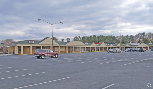
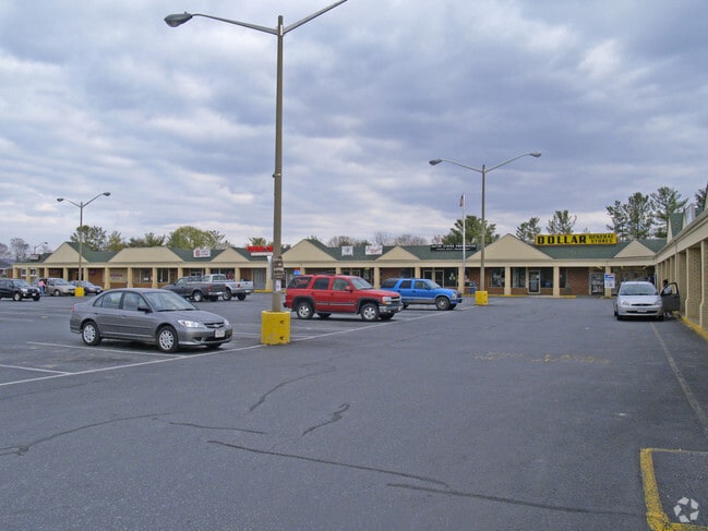
2857 Stuarts Draft Hwy
084F-7-3
84F-(7)-3 STUARTS DRAFT S RT 340 5.373ACRES
Commercialnec
Augusta
GENERAL BU
Virginia
B and X Area of moderate flood hazard, usually the area between the limits of the 100-year and 500-year floods.
5.37 AC
2026
Staunton & Harrisonburg
2026
Other Market Areas
071101
Staunton-Stuarts Draft, VA
123,849 SF
NEARBY LISTINGS FOR SALE OR LEASE
DEMOGRAPHICS near 2857 Stuarts Draft Hwy
1 mile
3 mile
5 mile
2025 Total Population
2,529
11,061
19,431
2030 Population
2,577
11,134
19,701
Pop Growth 2025-2030
+ 1.90%
+ 0.66%
+ 1.39%
Average Age
44
43
44
2025 Total Households
1,069
4,481
7,882
HH Growth 2025-2030
+ 1.96%
+ 0.78%
+ 1.51%
Median Household Inc
$59,932
$70,690
$69,423
Avg Household Size
2.20
2.40
2.40
2025 Avg HH Vehicles
2.00
2.00
2.00
Median Home Value
$304,181
$288,884
$294,758
Median Year Built
1989
1989
1990
Nearby Places
Map Layers
Map Styles
 Street
 Aerial
Layers
 Traffic
 Biking
Places
Listings with unknown addresses are not visible on the map
- Restaurants
- Banks
- Shops
- Fitness
- Groceries
PUBLIC TRANSPORTATION
AIRPORT
Charlottesville-Albemarle
Drive
Walk
Distance
Charlottesville-Albemarle
57 min
40.4 mi
Nearby Properties
Address
Land Use
TOTAL SIZE
Lot Size
Zoning
Address
Land Use
TOTAL SIZE
Lot Size
Zoning
1,555,974 SF
119.40 AC
GENERAL IN
Address
Land Use
TOTAL SIZE
Lot Size
Zoning
847,235 SF
301.72 AC
GENERAL IN
Address
Land Use
TOTAL SIZE
Lot Size
Zoning
111,337 SF
48.49 AC
GENERAL AG
Address
Land Use
TOTAL SIZE
Lot Size
Zoning
592,952 SF
171.54 AC
GENERAL IN
Address
Land Use
TOTAL SIZE
Lot Size
Zoning
162,201 SF
31.27 AC
GENERAL AG
Address
Land Use
TOTAL SIZE
Lot Size
Zoning
32,789 SF
20.01 AC
MULTI-FAMI
Address
Land Use
TOTAL SIZE
Lot Size
Zoning
270,213 SF
104.69 AC
GENERAL AG
Address
Land Use
TOTAL SIZE
Lot Size
Zoning
3,152 SF
17.16 AC
GENERAL AG
Address
Land Use
TOTAL SIZE
Lot Size
Zoning
285,650 SF
39.18 AC
GENERAL IN
Address
Land Use
TOTAL SIZE
Lot Size
Zoning
7,986 SF
132.59 AC
GENERAL AG
Address
Land Use
TOTAL SIZE
Lot Size
Zoning
260,908 SF
25.88 AC
GENERAL IN
Address
Land Use
TOTAL SIZE
Lot Size
Zoning
58,504 SF
10.15 AC
SINGLE FAM
Address
Land Use
TOTAL SIZE
Lot Size
Zoning
62,377 SF
5.83 AC
GENERAL BU
Address
Land Use
TOTAL SIZE
Lot Size
Zoning
191.92 AC
GENERAL AG
Address
Land Use
TOTAL SIZE
Lot Size
Zoning
10,704 SF
11 AC
MULTI-FAMI
Address
Land Use
TOTAL SIZE
Lot Size
Zoning
10,500 SF
9.30 AC
GENERAL BU
Address
Land Use
TOTAL SIZE
Lot Size
Zoning
37,167 SF
4.93 AC
MULTI-FAMI
Address
Land Use
TOTAL SIZE
Lot Size
Zoning
47.54 AC
MANUFACTUR
Address
Land Use
TOTAL SIZE
Lot Size
Zoning
13,994 SF
4.63 AC
MULTI-FAMI
Address
Land Use
TOTAL SIZE
Lot Size
Zoning
123,849 SF
5.37 AC
GENERAL BU
Address
Land Use
TOTAL SIZE
Lot Size
Zoning
72,946 SF
4.86 AC
MULTI-FAMI
Address
Land Use
TOTAL SIZE
Lot Size
Zoning
50,355 SF
9.32 AC
GENERAL AG
Address
Land Use
TOTAL SIZE
Lot Size
Zoning
93,200 SF
18.11 AC
GENERAL IN
Address
Land Use
TOTAL SIZE
Lot Size
Zoning
4,244 SF
4.38 AC
MULTI-FAMI
Address
Land Use
TOTAL SIZE
Lot Size
Zoning
33,159 SF
3.12 AC
MULTI-FAMI
Address
Land Use
TOTAL SIZE
Lot Size
Zoning
54,980 SF
9.56 AC
GENERAL AG
Address
Land Use
TOTAL SIZE
Lot Size
Zoning
8,004 SF
19.31 AC
MULTI-FAMI
Address
Land Use
TOTAL SIZE
Lot Size
Zoning
11,192 SF
2.75 AC
MULTI-FAMI
Address
Land Use
TOTAL SIZE
Lot Size
Zoning
13,947 SF
4.55 AC
GENERAL BU
The World's #1 Commercial Real Estate Marketplace
Connect with us
© 2026 CoStar Group
The information above has been obtained from sources believed reliable. While we do not doubt its accuracy we have not verified it and make no guarantee, warranty or representation about it. It is your responsibility to independently confirm its accuracy and completeness. Any projections, opinions, assumptions, or estimates used are for example only and do not represent the current or future performance of the property. The value of this transaction to you depends on tax and other factors which should be evaluated by your tax, financial, and legal advisors. You and your advisors should conduct a careful, independent investigation of the property to determine to your satisfaction the suitability of the property for your needs.