Property Record
28594 Naylor Mill Rd, Salisbury, MD 21801
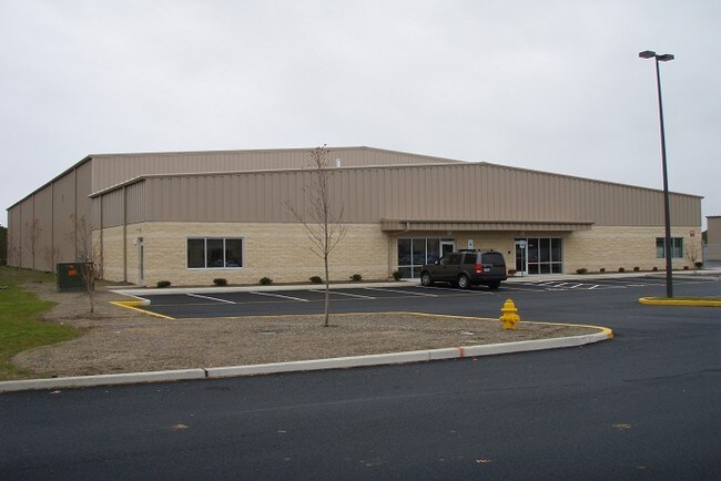

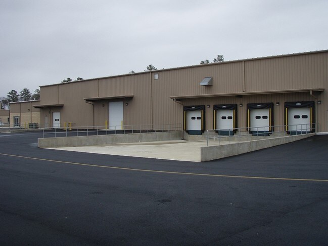

Property Detail
28594 Naylor Mill Rd
09-025847
BL B LOT 8-20.02 AC 28594 NAYLOR MILL RD WESTWOOD COMMERCE PK III
Distributionwarehouseregional
Wicomico
LI
Maryland
B and X Area of moderate flood hazard, usually the area between the limits of the 100-year and 500-year floods.
8
2024
20.02 AC
2025
Chesapeake Bay/Salisbury
010200
Other Market Areas
43,680 SF
Salisbury, MD
NEARBY LISTINGS FOR SALE OR LEASE
DEMOGRAPHICS near 28594 Naylor Mill Rd
1 mile
3 mile
5 mile
2025 Total Population
1,577
23,460
74,124
2030 Population
1,623
23,956
75,953
Pop Growth 2025-2030
+ 2.92%
+ 2.11%
+ 2.47%
Average Age
43
38
38
2025 Total Households
634
8,998
28,330
HH Growth 2025-2030
+ 3.00%
+ 2.18%
+ 2.52%
Median Household Inc
$63,264
$50,827
$66,381
Avg Household Size
2.50
2.50
2.40
2025 Avg HH Vehicles
2.00
2.00
2.00
Median Home Value
$239,354
$231,376
$252,258
Median Year Built
1998
1974
1981
Nearby Places
Map Layers
Map Styles
 Street
 Aerial
Layers
 Traffic
 Biking
Places
Listings with unknown addresses are not visible on the map
- Restaurants
- Banks
- Shops
- Fitness
- Groceries
PUBLIC TRANSPORTATION
AIRPORT
Salisbury-Ocean City Wicomico Regional
Drive
Walk
Distance
Salisbury-Ocean City Wicomico Regional
20 min
11.1 mi
Nearby Properties
Address
Land Use
TOTAL SIZE
Lot Size
Zoning
Address
Land Use
TOTAL SIZE
Lot Size
Zoning
602,336 SF
22.69 AC
H
Address
Land Use
TOTAL SIZE
Lot Size
Zoning
25,000 SF
23.46 AC
I-2
Address
Land Use
TOTAL SIZE
Lot Size
Zoning
118,330 SF
1.99 AC
CBD
Address
Land Use
TOTAL SIZE
Lot Size
Zoning
103,992 SF
0.59 AC
CBD
Address
Land Use
TOTAL SIZE
Lot Size
Zoning
105,626 SF
53.26 AC
R-8
Address
Land Use
TOTAL SIZE
Lot Size
Zoning
6,136 SF
52.49 AC
R-10
Address
Land Use
TOTAL SIZE
Lot Size
Zoning
40,690 SF
9.02 AC
PDD
Address
Land Use
TOTAL SIZE
Lot Size
Zoning
3,408 SF
69.67 AC
I
Address
Land Use
TOTAL SIZE
Lot Size
Zoning
76,999 SF
7.72 AC
R-8
Address
Land Use
TOTAL SIZE
Lot Size
Zoning
60,949 SF
14.13 AC
R-8
Address
Land Use
TOTAL SIZE
Lot Size
Zoning
1,034 SF
18.79 AC
R-8A
Address
Land Use
TOTAL SIZE
Lot Size
Zoning
41,473 SF
1.20 AC
CBD
Address
Land Use
TOTAL SIZE
Lot Size
Zoning
43,164 SF
1.83 AC
CBD
Address
Land Use
TOTAL SIZE
Lot Size
Zoning
37,198 SF
6.15 AC
LI
Address
Land Use
TOTAL SIZE
Lot Size
Zoning
15,260 SF
13.52 AC
R5A
Address
Land Use
TOTAL SIZE
Lot Size
Zoning
38,485 SF
24.09 AC
R-20
Address
Land Use
TOTAL SIZE
Lot Size
Zoning
5,151 SF
13.23 AC
LI
Address
Land Use
TOTAL SIZE
Lot Size
Zoning
1,804 SF
99.10 AC
R-20
Address
Land Use
TOTAL SIZE
Lot Size
Zoning
48,270 SF
2.30 AC
GC
Address
Land Use
TOTAL SIZE
Lot Size
Zoning
92,232 SF
20.83 AC
C
Address
Land Use
TOTAL SIZE
Lot Size
Zoning
37,645 SF
16.43 AC
IP
Address
Land Use
TOTAL SIZE
Lot Size
Zoning
135,750 SF
13.75 AC
R8
Address
Land Use
TOTAL SIZE
Lot Size
Zoning
36,177 SF
1.58 AC
GC
Address
Land Use
TOTAL SIZE
Lot Size
Zoning
20,970 SF
3.52 AC
Address
Land Use
TOTAL SIZE
Lot Size
Zoning
34,200 SF
15.95 AC
R-5A
Address
Land Use
TOTAL SIZE
Lot Size
Zoning
171,072 SF
15.19 AC
R-8A
Address
Land Use
TOTAL SIZE
Lot Size
Zoning
29,445 SF
5.09 AC
C 2
Address
Land Use
TOTAL SIZE
Lot Size
Zoning
5,040 SF
2.01 AC
GC
Address
Land Use
TOTAL SIZE
Lot Size
Zoning
25,642 SF
7.70 AC
CI
Address
Land Use
TOTAL SIZE
Lot Size
Zoning
22,163 SF
5 AC
LBR
The World's #1 Commercial Real Estate Marketplace
Connect with us
© 2026 CoStar Group
The information above has been obtained from sources believed reliable. While we do not doubt its accuracy we have not verified it and make no guarantee, warranty or representation about it. It is your responsibility to independently confirm its accuracy and completeness. Any projections, opinions, assumptions, or estimates used are for example only and do not represent the current or future performance of the property. The value of this transaction to you depends on tax and other factors which should be evaluated by your tax, financial, and legal advisors. You and your advisors should conduct a careful, independent investigation of the property to determine to your satisfaction the suitability of the property for your needs.