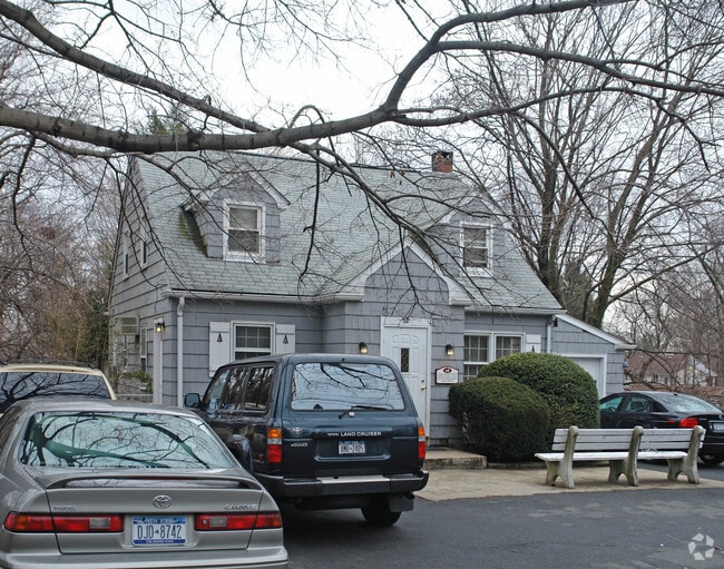
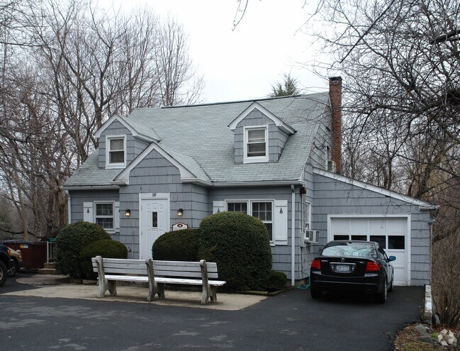
Property Record
286 N Middletown Rd, Pearl River, NY 10965
NEARBY LISTINGS FOR SALE OR LEASE
Property Detail
286 N Middletown Rd
392489-069-009-0001-042-000-0000
40/15/116/14
Kennel
Rockland
X
New York
36087C0159G
42.0
2023
0.56 AC
2024
Orangetown
012600
Northern New Jersey
240 SF
New York-Jersey City-White Plains, NY-NJ
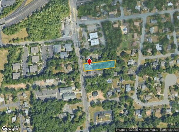
DEMOGRAPHICS near 286 N Middletown Rd
1 Mile
3 Mile
5 Mile
2024 Total Population
10,008
69,627
240,266
2029 Population
9,945
69,449
238,985
Pop Growth 2024-2029
(0.63%)
(0.26%)
(0.53%)
Average Age
41
41
37
2024 Total Households
3,619
23,363
72,546
HH Growth 2024-2029
(0.69%)
(0.24%)
(0.50%)
Median Household Inc
$118,897
$127,151
$107,563
Avg Household Size
2.70
2.90
3.10
2024 Avg HH Vehicles
2.00
2.00
2.00
Median Home Value
$496,170
$615,891
$643,203
Median Year Built
1957
1965
1968
Nearby Places
- Restaurants
- Banks
- Shops
- Fitness
- Groceries
PUBLIC TRANSPORTATION
COMMUTER RAIL
Pearl River (Pascack Valley Line - NJ Transit Commuter Rail (NJ Transit))
DRIVE
WALK
Distance
Pearl River (Pascack Valley Line - NJ Transit Commuter Rail (NJ Transit))
3 min
1.2 mi
Nanuet (Pascack Valley Line - NJ Transit Commuter Rail (NJ Transit))
DRIVE
WALK
Distance
Nanuet (Pascack Valley Line - NJ Transit Commuter Rail (NJ Transit))
4 min
1.5 mi
AIRPORT
Westchester County
DRIVE
WALK
Distance
Westchester County
35 min
23.7 mi
LaGuardia
DRIVE
WALK
Distance
LaGuardia
50 min
29.5 mi
Newark Liberty International
DRIVE
WALK
Distance
Newark Liberty International
45 min
32.2 mi
Freight Ports
Maher Terminal
DRIVE
WALK
Distance
Maher Terminal
55 min
35.3 mi
Nearby Properties
Address
Land Use
TOTAL SIZE
Lot Size
Zoning
Address
Land Use
TOTAL SIZE
Lot Size
Zoning
402,385 SF
23.10 AC
LI
Address
Land Use
TOTAL SIZE
Lot Size
Zoning
63,621 SF
180.20 AC
LI
Address
Land Use
TOTAL SIZE
Lot Size
Zoning
Address
Land Use
TOTAL SIZE
Lot Size
Zoning
Address
Land Use
TOTAL SIZE
Lot Size
Zoning
22.75 AC
Address
Land Use
TOTAL SIZE
Lot Size
Zoning
11.48 AC
OR-3
Address
Land Use
TOTAL SIZE
Lot Size
Zoning
37,600 SF
31.41 AC
Address
Land Use
TOTAL SIZE
Lot Size
Zoning
24.45 AC
R40
Address
Land Use
TOTAL SIZE
Lot Size
Zoning
1,295,615 SF
93.54 AC
OP
Address
Land Use
TOTAL SIZE
Lot Size
Zoning
298,975 SF
63.32 AC
03 - MULTI
Address
Land Use
TOTAL SIZE
Lot Size
Zoning
116,650 SF
39.20 AC
05
Address
Land Use
TOTAL SIZE
Lot Size
Zoning
8.02 AC
BUS2
Address
Land Use
TOTAL SIZE
Lot Size
Zoning
11.45 AC
A
Address
Land Use
TOTAL SIZE
Lot Size
Zoning
50,280 SF
24.37 AC
Address
Land Use
TOTAL SIZE
Lot Size
Zoning
132,614 SF
15.74 AC
OR3
Address
Land Use
TOTAL SIZE
Lot Size
Zoning
11.50 AC
OR1
Address
Land Use
TOTAL SIZE
Lot Size
Zoning
107,043 SF
11 AC
OR3
Address
Land Use
TOTAL SIZE
Lot Size
Zoning
152,854 SF
18.75 AC
RS
Address
Land Use
TOTAL SIZE
Lot Size
Zoning
Address
Land Use
TOTAL SIZE
Lot Size
Zoning
119,025 SF
16.57 AC
OR3
Address
Land Use
TOTAL SIZE
Lot Size
Zoning
13 AC
R40
Address
Land Use
TOTAL SIZE
Lot Size
Zoning
8.50 AC
R20
Address
Land Use
TOTAL SIZE
Lot Size
Zoning
10.66 AC
R15
Address
Land Use
TOTAL SIZE
Lot Size
Zoning
270,962 SF
21.80 AC
CS
Address
Land Use
TOTAL SIZE
Lot Size
Zoning
9.29 AC
OR3
Address
Land Use
TOTAL SIZE
Lot Size
Zoning
33.50 AC
Address
Land Use
TOTAL SIZE
Lot Size
Zoning
6,810 SF
120.70 AC
R-40
Address
Land Use
TOTAL SIZE
Lot Size
Zoning
67,962 SF
8.30 AC
02 - SINGL
Address
Land Use
TOTAL SIZE
Lot Size
Zoning
31.50 AC
R-15
Address
Land Use
TOTAL SIZE
Lot Size
Zoning
63,268 SF
104.70 AC
R-40
The World's #1 Commercial Real Estate Marketplace
Connect with us
© 2025 CoStar Group
The information above has been obtained from sources believed reliable. While we do not doubt its accuracy we have not verified it and make no guarantee, warranty or representation about it. It is your responsibility to independently confirm its accuracy and completeness. Any projections, opinions, assumptions, or estimates used are for example only and do not represent the current or future performance of the property. The value of this transaction to you depends on tax and other factors which should be evaluated by your tax, financial, and legal advisors. You and your advisors should conduct a careful, independent investigation of the property to determine to your satisfaction the suitability of the property for your needs.