Property Record
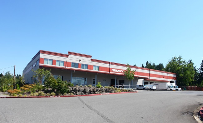
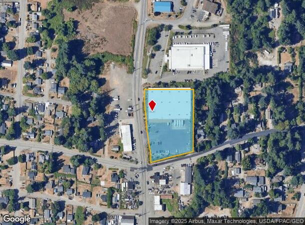
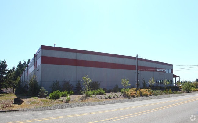
286 S National Ave, Bremerton, WA 98312
NEARBY LISTINGS FOR SALE OR LEASE
Property Detail
286 S National Ave
222401-2-107-2009
RESULTANT PARCEL OF BOUNDARY LINE ADJUSTMENT RECORDED UNDER AUDITORS FILE NO. 200606200002, RECORDS OF KITSAP COUNTY, WASHINGTON, DESCRIBED FOR TAX PURPOSES ONLY AS FOLLOWS: THAT PART OF THE NORTHEAST QUARTER [OF THE NORTHWEST QUARTER] AND THE SOUTHE
Warehouse
Kitsap
X
Washington
53035C0366F
107
2025
2.02 AC
2026
CBD
081000
Bremerton/Silverdale
37,125 SF
Bremerton-Silverdale, WA
DEMOGRAPHICS near 286 S National Ave
1 Mile
3 Mile
5 Mile
2024 Total Population
10,197
58,621
112,769
2029 Population
10,488
59,645
114,465
Pop Growth 2024-2029
+ 2.85%
+ 1.75%
+ 1.50%
Average Age
39
38
39
2024 Total Households
4,189
22,483
43,152
HH Growth 2024-2029
+ 3.17%
+ 2.01%
+ 1.64%
Median Household Inc
$53,459
$63,115
$69,580
Avg Household Size
2.20
2.30
2.40
2024 Avg HH Vehicles
2.00
2.00
2.00
Median Home Value
$302,065
$363,596
$398,676
Median Year Built
1966
1971
1978
Nearby Places
Map Layers
Map Styles
 Street
 Aerial
- Restaurants
- Banks
- Shops
- Fitness
- Groceries
PUBLIC TRANSPORTATION
AIRPORT
Seattle Paine Field International
DRIVE
WALK
Distance
Seattle Paine Field International
87 min
42.6 mi
Freight Ports
Port of Seattle
DRIVE
WALK
Distance
Port of Seattle
83 min
62.7 mi
Nearby Properties
Address
Land Use
TOTAL SIZE
Lot Size
Zoning
Address
Land Use
TOTAL SIZE
Lot Size
Zoning
21,408 SF
8.26 AC
BVSAP
Address
Land Use
TOTAL SIZE
Lot Size
Zoning
138,877 SF
7.17 AC
R-10
Address
Land Use
TOTAL SIZE
Lot Size
Zoning
135,371 SF
6.04 AC
R4
Address
Land Use
TOTAL SIZE
Lot Size
Zoning
112,847 SF
6.80 AC
UM
Address
Land Use
TOTAL SIZE
Lot Size
Zoning
151,599 SF
5.44 AC
R-40
Address
Land Use
TOTAL SIZE
Lot Size
Zoning
110,994 SF
5.35 AC
R4
Address
Land Use
TOTAL SIZE
Lot Size
Zoning
Address
Land Use
TOTAL SIZE
Lot Size
Zoning
1,344 SF
5.47 AC
R-40
Address
Land Use
TOTAL SIZE
Lot Size
Zoning
79,615 SF
1.25 AC
DSAP
Address
Land Use
TOTAL SIZE
Lot Size
Zoning
75,390 SF
4.46 AC
R-18
Address
Land Use
TOTAL SIZE
Lot Size
Zoning
122,799 SF
4.48 AC
R-40
Address
Land Use
TOTAL SIZE
Lot Size
Zoning
63,213 SF
4.15 AC
R-10
Address
Land Use
TOTAL SIZE
Lot Size
Zoning
58,376 SF
6.68 AC
R-18
Address
Land Use
TOTAL SIZE
Lot Size
Zoning
64,584 SF
4.92 AC
R-40
Address
Land Use
TOTAL SIZE
Lot Size
Zoning
68,079 SF
2.16 AC
BVSAP
Address
Land Use
TOTAL SIZE
Lot Size
Zoning
62,642 SF
4.91 AC
UM
Address
Land Use
TOTAL SIZE
Lot Size
Zoning
60,518 SF
2.62 AC
R-18
Address
Land Use
TOTAL SIZE
Lot Size
Zoning
55,412 SF
1.74 AC
R-18
Address
Land Use
TOTAL SIZE
Lot Size
Zoning
73,931 SF
11.72 AC
FC
Address
Land Use
TOTAL SIZE
Lot Size
Zoning
43,944 SF
2.64 AC
FC
Address
Land Use
TOTAL SIZE
Lot Size
Zoning
47,584 SF
3.76 AC
R-40
Address
Land Use
TOTAL SIZE
Lot Size
Zoning
45,682 SF
2.04 AC
GC
Address
Land Use
TOTAL SIZE
Lot Size
Zoning
75,225 SF
3.30 AC
R-10
Address
Land Use
TOTAL SIZE
Lot Size
Zoning
55,866 SF
8.48 AC
FC
Address
Land Use
TOTAL SIZE
Lot Size
Zoning
48,520 SF
3.76 AC
GC
Address
Land Use
TOTAL SIZE
Lot Size
Zoning
44,220 SF
2.86 AC
R-40
Address
Land Use
TOTAL SIZE
Lot Size
Zoning
60,977 SF
0.47 AC
DSAP
Address
Land Use
TOTAL SIZE
Lot Size
Zoning
68,708 SF
7.89 AC
PF
Address
Land Use
TOTAL SIZE
Lot Size
Zoning
24,930 SF
0.33 AC
DSAP
Address
Land Use
TOTAL SIZE
Lot Size
Zoning
38,502 SF
5.92 AC
R-40
The World's #1 Commercial Real Estate Marketplace
Connect with us
© 2025 CoStar Group
The information above has been obtained from sources believed reliable. While we do not doubt its accuracy we have not verified it and make no guarantee, warranty or representation about it. It is your responsibility to independently confirm its accuracy and completeness. Any projections, opinions, assumptions, or estimates used are for example only and do not represent the current or future performance of the property. The value of this transaction to you depends on tax and other factors which should be evaluated by your tax, financial, and legal advisors. You and your advisors should conduct a careful, independent investigation of the property to determine to your satisfaction the suitability of the property for your needs.