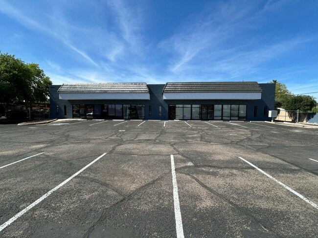
Property Record
2860 E Mckellips Rd, Mesa, AZ 85213

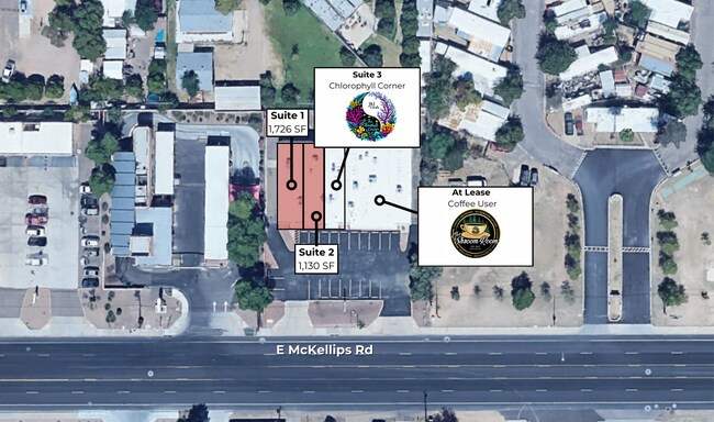

Current Lease Availabilities
Property Detail
2860 E Mckellips Rd
141-15-036
REDROCK MOBILE HOME ESTATES MCR 116-23
Storebuilding
Maricopa
C-C
Arizona
C and X Area of minimal flood hazard, usually depicted on FIRMs as above the 500-year flood level.
15
2025
0.59 AC
2025
Red Mountain/Mesa
420303
Phoenix
8,120 SF
Phoenix-Mesa-Chandler, AZ
NEARBY LISTINGS FOR SALE OR LEASE
DEMOGRAPHICS near 2860 E Mckellips Rd
1 mile
3 mile
5 mile
2025 Total Population
12,778
89,862
264,657
2030 Population
13,150
93,178
275,629
Pop Growth 2025-2030
+ 2.91%
+ 3.69%
+ 4.15%
Average Age
39
40
41
2025 Total Households
4,111
33,296
101,347
HH Growth 2025-2030
+ 2.92%
+ 4.08%
+ 4.56%
Median Household Inc
$124,379
$85,502
$73,070
Avg Household Size
3.00
2.60
2.50
2025 Avg HH Vehicles
2.00
2.00
2.00
Median Home Value
$656,619
$442,632
$391,233
Median Year Built
1988
1984
1984
Nearby Places
Map Layers
Map Styles
 Street
 Aerial
Transit
 Traffic
 Biking
Places
Listings with unknown addresses are not visible on the map
- Restaurants
- Banks
- Shops
- Fitness
- Groceries
PUBLIC TRANSPORTATION
AIRPORT
Phoenix Sky Harbor International
Drive
Walk
Distance
Phoenix Sky Harbor International
23 min
14.4 mi
Phoenix-Mesa Gateway
Drive
Walk
Distance
Phoenix-Mesa Gateway
29 min
16.3 mi
Nearby Properties
Address
Land Use
TOTAL SIZE
Lot Size
Zoning
Address
Land Use
TOTAL SIZE
Lot Size
Zoning
181.80 AC
Address
Land Use
TOTAL SIZE
Lot Size
Zoning
125,356 SF
21.63 AC
R-9
Address
Land Use
TOTAL SIZE
Lot Size
Zoning
1,691,248 SF
528.80 AC
I-1
Address
Land Use
TOTAL SIZE
Lot Size
Zoning
1,217,466 SF
102.41 AC
I-1
Address
Land Use
TOTAL SIZE
Lot Size
Zoning
400,798 SF
55.94 AC
PF
Address
Land Use
TOTAL SIZE
Lot Size
Zoning
579,506 SF
17.78 AC
PF
Address
Land Use
TOTAL SIZE
Lot Size
Zoning
20.08 AC
Address
Land Use
TOTAL SIZE
Lot Size
Zoning
161,388 SF
32.52 AC
R-35
Address
Land Use
TOTAL SIZE
Lot Size
Zoning
66,350 SF
22.32 AC
I-1
Address
Land Use
TOTAL SIZE
Lot Size
Zoning
158,514 SF
21.39 AC
Address
Land Use
TOTAL SIZE
Lot Size
Zoning
147,408 SF
34.58 AC
PF
Address
Land Use
TOTAL SIZE
Lot Size
Zoning
349,318 SF
18.47 AC
M-H
Address
Land Use
TOTAL SIZE
Lot Size
Zoning
359,204 SF
40.94 AC
LI
Address
Land Use
TOTAL SIZE
Lot Size
Zoning
266,240 SF
9.75 AC
M-H
Address
Land Use
TOTAL SIZE
Lot Size
Zoning
321,591 SF
15.68 AC
M-H
Address
Land Use
TOTAL SIZE
Lot Size
Zoning
225,233 SF
21.66 AC
C-G
Address
Land Use
TOTAL SIZE
Lot Size
Zoning
125,534 SF
19.59 AC
I-2
Address
Land Use
TOTAL SIZE
Lot Size
Zoning
81,000 SF
15.70 AC
AG
Address
Land Use
TOTAL SIZE
Lot Size
Zoning
157,048 SF
10.75 AC
Address
Land Use
TOTAL SIZE
Lot Size
Zoning
263,918 SF
15.36 AC
M-H
Address
Land Use
TOTAL SIZE
Lot Size
Zoning
209,538 SF
13.47 AC
M-M
Address
Land Use
TOTAL SIZE
Lot Size
Zoning
72,598 SF
38.83 AC
AG
Address
Land Use
TOTAL SIZE
Lot Size
Zoning
70,871 SF
9.95 AC
I-1
Address
Land Use
TOTAL SIZE
Lot Size
Zoning
133,219 SF
8.65 AC
I-1
Address
Land Use
TOTAL SIZE
Lot Size
Zoning
10 SF
0.91 AC
AG
Address
Land Use
TOTAL SIZE
Lot Size
Zoning
191,871 SF
9.51 AC
M-H
Address
Land Use
TOTAL SIZE
Lot Size
Zoning
265,888 SF
2.92 AC
M-H
Address
Land Use
TOTAL SIZE
Lot Size
Zoning
57,048 SF
5.19 AC
C-G
Address
Land Use
TOTAL SIZE
Lot Size
Zoning
108,492 SF
11.31 AC
C-G
Address
Land Use
TOTAL SIZE
Lot Size
Zoning
80,320 SF
11.11 AC
R-9
The World's #1 Commercial Real Estate Marketplace
Connect with us
© 2026 CoStar Group
The information above has been obtained from sources believed reliable. While we do not doubt its accuracy we have not verified it and make no guarantee, warranty or representation about it. It is your responsibility to independently confirm its accuracy and completeness. Any projections, opinions, assumptions, or estimates used are for example only and do not represent the current or future performance of the property. The value of this transaction to you depends on tax and other factors which should be evaluated by your tax, financial, and legal advisors. You and your advisors should conduct a careful, independent investigation of the property to determine to your satisfaction the suitability of the property for your needs.