Property Record
28624 Witherspoon Pky, Valencia, CA 91355


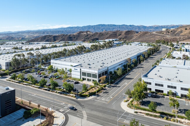

Property Detail
28624 Witherspoon Pky
3271-028-126
P M 298-61-67 LOTS 4,5,6 AND 7
Warehouse
Los Angeles
LCA22-A25*
California
B and X Area of moderate flood hazard, usually the area between the limits of the 100-year and 500-year floods.
4-7
2024
9.51 AC
2025
Santa Clarita Valley
920106
Los Angeles
204,350 SF
Los Angeles-Long Beach-Glendale, CA
NEARBY LISTINGS FOR SALE OR LEASE
DEMOGRAPHICS near 28624 Witherspoon Pky
1 mile
3 mile
5 mile
2025 Total Population
1,971
21,930
62,523
2030 Population
1,942
22,020
62,238
Pop Growth 2025-2030
(1.47%)
+ 0.41%
(0.46%)
Average Age
39
40
39
2025 Total Households
578
5,166
18,688
HH Growth 2025-2030
(1.73%)
+ 0.79%
(0.57%)
Median Household Inc
$144,886
$159,763
$146,405
Avg Household Size
3.40
3.10
3.00
2025 Avg HH Vehicles
3.00
3.00
2.00
Median Home Value
$737,922
$749,646
$828,600
Median Year Built
1992
1997
2001
Nearby Places
Map Layers
Map Styles
 Street
 Aerial
Transit
 Traffic
 Biking
Places
Listings with unknown addresses are not visible on the map
- Restaurants
- Banks
- Shops
- Fitness
- Groceries
PUBLIC TRANSPORTATION
COMMUTER RAIL
Santa Clarita (Antelope Valley Line - Southern California Regional Rail Authority (Metrolink))
Drive
Walk
Distance
Santa Clarita (Antelope Valley Line - Southern California Regional Rail Authority (Metrolink))
16 min
8.7 mi
AIRPORT
Bob Hope
Drive
Walk
Distance
Bob Hope
36 min
26.3 mi
Freight Ports
The Port of Hueneme
Drive
Walk
Distance
The Port of Hueneme
70 min
48.5 mi
Nearby Properties
Address
Land Use
TOTAL SIZE
Lot Size
Zoning
Address
Land Use
TOTAL SIZE
Lot Size
Zoning
357,508 SF
13.73 AC
LCA25*
Address
Land Use
TOTAL SIZE
Lot Size
Zoning
114,136 SF
209.56 AC
LCCR*
Address
Land Use
TOTAL SIZE
Lot Size
Zoning
356,265 SF
4.87 AC
SCBP
Address
Land Use
TOTAL SIZE
Lot Size
Zoning
165,624 SF
8.76 AC
LCA22-A25*
Address
Land Use
TOTAL SIZE
Lot Size
Zoning
121,020 SF
5.94 AC
SCBP
Address
Land Use
TOTAL SIZE
Lot Size
Zoning
174,750 SF
9 AC
LCM1.5
Address
Land Use
TOTAL SIZE
Lot Size
Zoning
152,070 SF
11.84 AC
LCA22-A25*
Address
Land Use
TOTAL SIZE
Lot Size
Zoning
164,964 SF
7.70 AC
LCM1.5
Address
Land Use
TOTAL SIZE
Lot Size
Zoning
229,179 SF
6.04 AC
LCA22-A25*
Address
Land Use
TOTAL SIZE
Lot Size
Zoning
187,404 SF
10.08 AC
MPD
Address
Land Use
TOTAL SIZE
Lot Size
Zoning
86,025 SF
8.01 AC
SCBP
Address
Land Use
TOTAL SIZE
Lot Size
Zoning
145,250 SF
6.77 AC
SCBP
Address
Land Use
TOTAL SIZE
Lot Size
Zoning
188,795 SF
6.69 AC
LCA22-A25*
Address
Land Use
TOTAL SIZE
Lot Size
Zoning
126,208 SF
3.92 AC
SCBP
Address
Land Use
TOTAL SIZE
Lot Size
Zoning
133,787 SF
6.17 AC
LCA22-A25*
Address
Land Use
TOTAL SIZE
Lot Size
Zoning
124,066 SF
6.32 AC
SCBP
Address
Land Use
TOTAL SIZE
Lot Size
Zoning
116,225 SF
6.83 AC
LCA22-A25*
Address
Land Use
TOTAL SIZE
Lot Size
Zoning
109,844 SF
5.75 AC
LCA22-A25*
Address
Land Use
TOTAL SIZE
Lot Size
Zoning
104,954 SF
7.88 AC
LCA25*
Address
Land Use
TOTAL SIZE
Lot Size
Zoning
80,077 SF
3.55 AC
SCBP
Address
Land Use
TOTAL SIZE
Lot Size
Zoning
216,320 SF
11.35 AC
LCA22*
Address
Land Use
TOTAL SIZE
Lot Size
Zoning
113,042 SF
6.63 AC
MPD
Address
Land Use
TOTAL SIZE
Lot Size
Zoning
105,061 SF
5.40 AC
SCBP
Address
Land Use
TOTAL SIZE
Lot Size
Zoning
206,474 SF
10.33 AC
LCA22-A25*
Address
Land Use
TOTAL SIZE
Lot Size
Zoning
134,040 SF
13.66 AC
LCM1.5
Address
Land Use
TOTAL SIZE
Lot Size
Zoning
125,020 SF
5.54 AC
LCA25*
Address
Land Use
TOTAL SIZE
Lot Size
Zoning
0.42 AC
LCA25*
The World's #1 Commercial Real Estate Marketplace
Connect with us
© 2026 CoStar Group
The information above has been obtained from sources believed reliable. While we do not doubt its accuracy we have not verified it and make no guarantee, warranty or representation about it. It is your responsibility to independently confirm its accuracy and completeness. Any projections, opinions, assumptions, or estimates used are for example only and do not represent the current or future performance of the property. The value of this transaction to you depends on tax and other factors which should be evaluated by your tax, financial, and legal advisors. You and your advisors should conduct a careful, independent investigation of the property to determine to your satisfaction the suitability of the property for your needs.