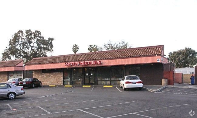
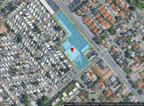
Property Record
2859 Senter Rd, San Jose, CA 95111

NEARBY LISTINGS FOR SALE OR LEASE
Property Detail
2859 Senter Rd
Storebuilding
Santa Clara
D
California
06085C0262H
4.26 AC
2024
East San Jose-Willow Glen
2025
South Bay/San Jose
503222
San Jose-Sunnyvale-Santa Clara, CA
33,360 SF
497-28-002
DEMOGRAPHICS near 2859 Senter Rd
1 Mile
3 Mile
5 Mile
2024 Total Population
28,231
231,840
617,130
2029 Population
26,840
222,335
592,221
Pop Growth 2024-2029
(4.93%)
(4.10%)
(4.04%)
Average Age
40
39
39
2024 Total Households
7,568
67,011
193,084
HH Growth 2024-2029
(5.21%)
(4.27%)
(4.14%)
Median Household Inc
$79,725
$106,034
$114,491
Avg Household Size
3.50
3.30
3.00
2024 Avg HH Vehicles
2.00
2.00
2.00
Median Home Value
$597,075
$840,245
$1,002,041
Median Year Built
1978
1976
1975
Nearby Places
Map Layers
Map Styles
 Street
 Aerial
- Restaurants
- Banks
- Shops
- Fitness
- Groceries
PUBLIC TRANSPORTATION
COMMUTER RAIL
Capitol (Caltrain - Caltrain (Caltrain))
DRIVE
WALK
Distance
Capitol (Caltrain - Caltrain (Caltrain))
4 min
1.8 mi
Tamien (Caltrain - Caltrain (Caltrain))
DRIVE
WALK
Distance
Tamien (Caltrain - Caltrain (Caltrain))
10 min
3.6 mi
AIRPORT
Norman Y Mineta San Jose International
DRIVE
WALK
Distance
Norman Y Mineta San Jose International
15 min
10.8 mi
Nearby Properties
Address
Land Use
TOTAL SIZE
Lot Size
Zoning
Address
Land Use
TOTAL SIZE
Lot Size
Zoning
11.96 AC
M4
Address
Land Use
TOTAL SIZE
Lot Size
Zoning
1.16 AC
R1BD
Address
Land Use
TOTAL SIZE
Lot Size
Zoning
414,727 SF
16.59 AC
PD
Address
Land Use
TOTAL SIZE
Lot Size
Zoning
358,302 SF
33.45 AC
M4
Address
Land Use
TOTAL SIZE
Lot Size
Zoning
233,709 SF
3.87 AC
APD
Address
Land Use
TOTAL SIZE
Lot Size
Zoning
0.13 AC
R1B6
Address
Land Use
TOTAL SIZE
Lot Size
Zoning
241,800 SF
15.07 AC
R4
Address
Land Use
TOTAL SIZE
Lot Size
Zoning
209,128 SF
13.13 AC
R1PD
Address
Land Use
TOTAL SIZE
Lot Size
Zoning
279,086 SF
10.74 AC
R3
Address
Land Use
TOTAL SIZE
Lot Size
Zoning
8.72 AC
A-PD
Address
Land Use
TOTAL SIZE
Lot Size
Zoning
6.21 AC
APD
Address
Land Use
TOTAL SIZE
Lot Size
Zoning
358,320 SF
4.97 AC
R1-20
Address
Land Use
TOTAL SIZE
Lot Size
Zoning
155,286 SF
9.50 AC
R3
Address
Land Use
TOTAL SIZE
Lot Size
Zoning
120,816 SF
5.45 AC
C3PD
Address
Land Use
TOTAL SIZE
Lot Size
Zoning
6.24 AC
A-PD
Address
Land Use
TOTAL SIZE
Lot Size
Zoning
113.46 AC
M4
Address
Land Use
TOTAL SIZE
Lot Size
Zoning
21.67 AC
R3B
Address
Land Use
TOTAL SIZE
Lot Size
Zoning
255,590 SF
4.97 AC
A-PD
Address
Land Use
TOTAL SIZE
Lot Size
Zoning
163,904 SF
9.48 AC
R3APD
Address
Land Use
TOTAL SIZE
Lot Size
Zoning
5.05 AC
APD
Address
Land Use
TOTAL SIZE
Lot Size
Zoning
1.66 AC
APD
Address
Land Use
TOTAL SIZE
Lot Size
Zoning
549,100 SF
51.91 AC
CG
Address
Land Use
TOTAL SIZE
Lot Size
Zoning
151,200 SF
5.82 AC
APD
Address
Land Use
TOTAL SIZE
Lot Size
Zoning
189,598 SF
2.20 AC
APD
Address
Land Use
TOTAL SIZE
Lot Size
Zoning
10.42 AC
PD
Address
Land Use
TOTAL SIZE
Lot Size
Zoning
124,000 SF
13.12 AC
C1
Address
Land Use
TOTAL SIZE
Lot Size
Zoning
450,000 SF
13.53 AC
HI
Address
Land Use
TOTAL SIZE
Lot Size
Zoning
46,440 SF
3.57 AC
R-1-8
Address
Land Use
TOTAL SIZE
Lot Size
Zoning
137,020 SF
9.35 AC
M4
Address
Land Use
TOTAL SIZE
Lot Size
Zoning
117,808 SF
5.14 AC
C3H
The World's #1 Commercial Real Estate Marketplace
Connect with us
© 2026 CoStar Group
The information above has been obtained from sources believed reliable. While we do not doubt its accuracy we have not verified it and make no guarantee, warranty or representation about it. It is your responsibility to independently confirm its accuracy and completeness. Any projections, opinions, assumptions, or estimates used are for example only and do not represent the current or future performance of the property. The value of this transaction to you depends on tax and other factors which should be evaluated by your tax, financial, and legal advisors. You and your advisors should conduct a careful, independent investigation of the property to determine to your satisfaction the suitability of the property for your needs.