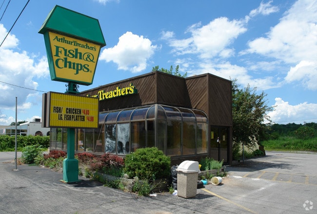
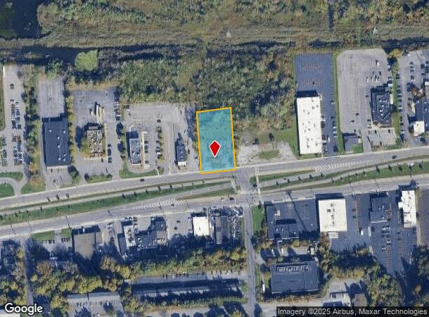
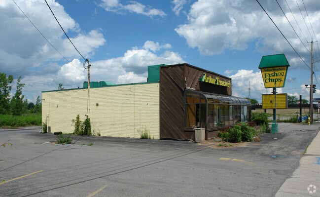
Property Record
2865 Erie Blvd E, Syracuse, NY 13224
NEARBY LISTINGS FOR SALE OR LEASE
Property Detail
2865 Erie Blvd E
Syracuse, NY
ML 41 LOT 1 2 3 P ABAND S 140X250 MAS BLDG FP154
311500-033-000-0001-016-000-0000
Onondaga
Commercialacreage
New York
X
16.000
36067C0237F
0.80 AC
2025
Greater Syracuse
2024
Syracuse
003602
DEMOGRAPHICS near 2865 Erie Blvd E
1 Mile
3 Mile
5 Mile
2024 Total Population
11,505
95,660
196,305
2029 Population
11,290
93,381
192,190
Pop Growth 2024-2029
(1.87%)
(2.38%)
(2.10%)
Average Age
39
37
38
2024 Total Households
4,789
38,333
79,809
HH Growth 2024-2029
(1.80%)
(2.40%)
(2.16%)
Median Household Inc
$56,520
$49,111
$49,038
Avg Household Size
2.10
2.10
2.20
2024 Avg HH Vehicles
1.00
1.00
1.00
Median Home Value
$120,661
$151,449
$144,699
Median Year Built
1953
1952
1952
Nearby Places
- Restaurants
- Banks
- Shops
- Fitness
- Groceries
PUBLIC TRANSPORTATION
COMMUTER RAIL
DRIVE
WALK
Distance
11 min
5.6 mi
DRIVE
WALK
Distance
11 min
5.6 mi
AIRPORT
Syracuse Hancock International
DRIVE
WALK
Distance
Syracuse Hancock International
17 min
10.2 mi
Nearby Properties
Address
Land Use
TOTAL SIZE
Lot Size
Zoning
Address
Land Use
TOTAL SIZE
Lot Size
Zoning
70,284 SF
74.57 AC
25
Address
Land Use
TOTAL SIZE
Lot Size
Zoning
508,658 SF
2.23 AC
25
Address
Land Use
TOTAL SIZE
Lot Size
Zoning
459,040 SF
4.71 AC
06 - INDUS
Address
Land Use
TOTAL SIZE
Lot Size
Zoning
826,528 SF
2.28 AC
06 - INDUS
Address
Land Use
TOTAL SIZE
Lot Size
Zoning
269,030 SF
11.90 AC
05 - COMME
Address
Land Use
TOTAL SIZE
Lot Size
Zoning
348,998 SF
65.59 AC
25
Address
Land Use
TOTAL SIZE
Lot Size
Zoning
72,200 SF
12.39 AC
06 - INDUS
Address
Land Use
TOTAL SIZE
Lot Size
Zoning
354,492 SF
6.90 AC
25
Address
Land Use
TOTAL SIZE
Lot Size
Zoning
72,800 SF
1.89 AC
06 - INDUS
Address
Land Use
TOTAL SIZE
Lot Size
Zoning
409,062 SF
10
Address
Land Use
TOTAL SIZE
Lot Size
Zoning
522,469 SF
1.87 AC
14
Address
Land Use
TOTAL SIZE
Lot Size
Zoning
218,051 SF
2.32 AC
25
Address
Land Use
TOTAL SIZE
Lot Size
Zoning
6,598 SF
4.09 AC
14
Address
Land Use
TOTAL SIZE
Lot Size
Zoning
38,693 SF
102.34 AC
05 - COMME
Address
Land Use
TOTAL SIZE
Lot Size
Zoning
24,360 SF
3.99 AC
10
Address
Land Use
TOTAL SIZE
Lot Size
Zoning
108,368 SF
3.36 AC
14
Address
Land Use
TOTAL SIZE
Lot Size
Zoning
414,700 SF
1.94 AC
07 - MIXED
Address
Land Use
TOTAL SIZE
Lot Size
Zoning
2,709 SF
39.74 AC
06 - INDUS
Address
Land Use
TOTAL SIZE
Lot Size
Zoning
1.67 AC
06 - INDUS
Address
Land Use
TOTAL SIZE
Lot Size
Zoning
224,736 SF
2.48 AC
10
Address
Land Use
TOTAL SIZE
Lot Size
Zoning
165,800 SF
1.27 AC
25
Address
Land Use
TOTAL SIZE
Lot Size
Zoning
164,837 SF
0.66 AC
10
Address
Land Use
TOTAL SIZE
Lot Size
Zoning
105,004 SF
2.81 AC
25
Address
Land Use
TOTAL SIZE
Lot Size
Zoning
569,463 SF
94.77 AC
06 - INDUS
Address
Land Use
TOTAL SIZE
Lot Size
Zoning
168,000 SF
2.18 AC
06 - INDUS
Address
Land Use
TOTAL SIZE
Lot Size
Zoning
296,703 SF
1.48 AC
25
Address
Land Use
TOTAL SIZE
Lot Size
Zoning
307,860 SF
1.17 AC
25
Address
Land Use
TOTAL SIZE
Lot Size
Zoning
12,836 SF
148.95 AC
06 - INDUS
Address
Land Use
TOTAL SIZE
Lot Size
Zoning
5,837 SF
1.26 AC
15
Address
Land Use
TOTAL SIZE
Lot Size
Zoning
50,472 SF
4.89 AC
10
The World's #1 Commercial Real Estate Marketplace
Connect with us
© 2025 CoStar Group
The information above has been obtained from sources believed reliable. While we do not doubt its accuracy we have not verified it and make no guarantee, warranty or representation about it. It is your responsibility to independently confirm its accuracy and completeness. Any projections, opinions, assumptions, or estimates used are for example only and do not represent the current or future performance of the property. The value of this transaction to you depends on tax and other factors which should be evaluated by your tax, financial, and legal advisors. You and your advisors should conduct a careful, independent investigation of the property to determine to your satisfaction the suitability of the property for your needs.