Property Record
287 Elam Rd, Ray, OH 45672


Property Detail
287 Elam Rd
E08-002-00-120-02
NW
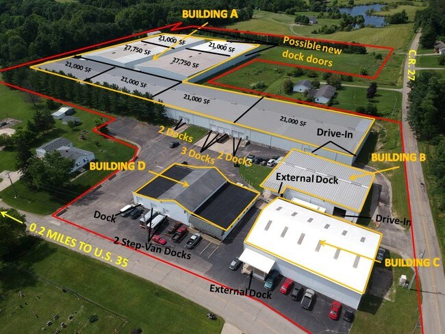
Warehouse
Jackson
B and X Area of moderate flood hazard, usually the area between the limits of the 100-year and 500-year floods.
Ohio
2025
12.27 AC
2025
Ohio South Area
957400
Other Market Areas
11,200 SF
NEARBY LISTINGS FOR SALE OR LEASE
-
-
View all Ray listings for sale on LoopNet.com
DEMOGRAPHICS near 287 Elam Rd
1 mile
3 mile
5 mile
2025 Total Population
323
1,354
3,211
2030 Population
331
1,374
3,256
Pop Growth 2025-2030
+ 2.48%
+ 1.48%
+ 1.40%
Average Age
43
42
42
2025 Total Households
128
534
1,258
HH Growth 2025-2030
+ 2.34%
+ 1.50%
+ 1.43%
Median Household Inc
$64,091
$62,912
$63,224
Avg Household Size
2.50
2.50
2.50
2025 Avg HH Vehicles
2.00
2.00
2.00
Median Home Value
$135,135
$182,330
$186,977
Median Year Built
1983
1982
1982
Nearby Places
Map Layers
Map Styles
 Street
 Aerial
Layers
 Traffic
 Biking
Places
Listings with unknown addresses are not visible on the map
- Restaurants
- Banks
- Shops
- Fitness
- Groceries
SALE & LEASE HISTORY
LISTING DATE
SALE/LEASE

Sep 25, 2016
For Lease
Sep 25, 2016
For Lease
Sep 23, 2016
For Sale
Sep 15, 2017
For Sale
Sep 15, 2017
For Lease
May 03, 2023
For Sale
Mar 08, 2023
For Sale
Jan 23, 2019
For Lease
Jan 23, 2019
For Sale
Aug 21, 2024
For Sale
Nearby Properties
Address
Land Use
TOTAL SIZE
Lot Size
Zoning
Address
Land Use
TOTAL SIZE
Lot Size
Zoning
14,000 SF
11.54 AC
Address
Land Use
TOTAL SIZE
Lot Size
Zoning
231 SF
198.14 AC
Address
Land Use
TOTAL SIZE
Lot Size
Zoning
475 AC
Address
Land Use
TOTAL SIZE
Lot Size
Zoning
413 AC
Address
Land Use
TOTAL SIZE
Lot Size
Zoning
374.55 AC
Address
Land Use
TOTAL SIZE
Lot Size
Zoning
7,656 SF
153.27 AC
Address
Land Use
TOTAL SIZE
Lot Size
Zoning
355 AC
Address
Land Use
TOTAL SIZE
Lot Size
Zoning
297.29 AC
Address
Land Use
TOTAL SIZE
Lot Size
Zoning
7,686 SF
0.26 AC
Address
Land Use
TOTAL SIZE
Lot Size
Zoning
10,780 SF
2.32 AC
Address
Land Use
TOTAL SIZE
Lot Size
Zoning
213.31 AC
Address
Land Use
TOTAL SIZE
Lot Size
Zoning
195 AC
Address
Land Use
TOTAL SIZE
Lot Size
Zoning
4,182 SF
110.36 AC
Address
Land Use
TOTAL SIZE
Lot Size
Zoning
4,860 SF
23.71 AC
Address
Land Use
TOTAL SIZE
Lot Size
Zoning
175 AC
Address
Land Use
TOTAL SIZE
Lot Size
Zoning
8,400 SF
1.47 AC
Address
Land Use
TOTAL SIZE
Lot Size
Zoning
3,340 SF
11.49 AC
Address
Land Use
TOTAL SIZE
Lot Size
Zoning
9,202 SF
0.33 AC
Address
Land Use
TOTAL SIZE
Lot Size
Zoning
3,150 SF
15.38 AC
Address
Land Use
TOTAL SIZE
Lot Size
Zoning
Address
Land Use
TOTAL SIZE
Lot Size
Zoning
4,306 SF
121.10 AC
Address
Land Use
TOTAL SIZE
Lot Size
Zoning
3,816 SF
110.87 AC
Address
Land Use
TOTAL SIZE
Lot Size
Zoning
2,454 SF
249.58 AC
Address
Land Use
TOTAL SIZE
Lot Size
Zoning
1,664 SF
146.22 AC
Address
Land Use
TOTAL SIZE
Lot Size
Zoning
1,485 SF
1 AC
Address
Land Use
TOTAL SIZE
Lot Size
Zoning
2,640 SF
83.81 AC
Address
Land Use
TOTAL SIZE
Lot Size
Zoning
Address
Land Use
TOTAL SIZE
Lot Size
Zoning
3,224 SF
14.97 AC
Address
Land Use
TOTAL SIZE
Lot Size
Zoning
3,456 SF
123.25 AC
The World's #1 Commercial Real Estate Marketplace
Connect with us
© 2026 CoStar Group
The information above has been obtained from sources believed reliable. While we do not doubt its accuracy we have not verified it and make no guarantee, warranty or representation about it. It is your responsibility to independently confirm its accuracy and completeness. Any projections, opinions, assumptions, or estimates used are for example only and do not represent the current or future performance of the property. The value of this transaction to you depends on tax and other factors which should be evaluated by your tax, financial, and legal advisors. You and your advisors should conduct a careful, independent investigation of the property to determine to your satisfaction the suitability of the property for your needs.