Property Record
287 Main St, Hope, RI 02831
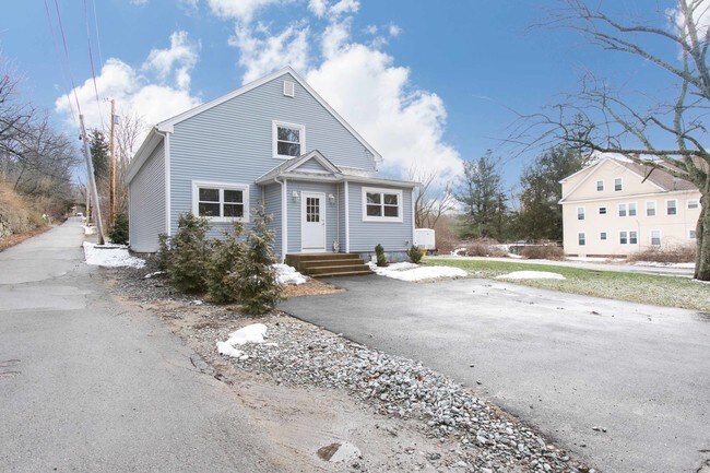

Property Detail
287 Main St
CRAN-000030-000001-000037
Providence
Commercialofficeresidentialmixeduse
Rhode Island
C4
37
B and X Area of moderate flood hazard, usually the area between the limits of the 100-year and 500-year floods.
0.46 AC
2025
Cranston
2025
Providence
014600
Providence-Warwick, RI-MA
1,360 SF
NEARBY LISTINGS FOR SALE OR LEASE
-
-
View all Hope listings for sale on LoopNet.com
DEMOGRAPHICS near 287 Main St
1 mile
3 mile
5 mile
2025 Total Population
3,887
39,703
110,228
2030 Population
3,991
40,487
112,766
Pop Growth 2025-2030
+ 2.68%
+ 1.97%
+ 2.30%
Average Age
42
41
43
2025 Total Households
1,467
16,131
45,559
HH Growth 2025-2030
+ 2.79%
+ 1.87%
+ 2.28%
Median Household Inc
$136,954
$95,230
$92,964
Avg Household Size
2.60
2.40
2.30
2025 Avg HH Vehicles
2.00
2.00
2.00
Median Home Value
$445,265
$381,534
$377,493
Median Year Built
1961
1961
1970
Nearby Places
Map Layers
Map Styles
 Street
 Aerial
Transit
 Traffic
 Biking
Places
Listings with unknown addresses are not visible on the map
- Restaurants
- Banks
- Shops
- Fitness
- Groceries
PUBLIC TRANSPORTATION
COMMUTER RAIL
Tf Green Airport (Providence/Stoughton Line - MBTA)
Drive
Walk
Distance
Tf Green Airport (Providence/Stoughton Line - MBTA)
15 min
8.1 mi
AIRPORT
Rhode Island Tf Green International
Drive
Walk
Distance
Rhode Island Tf Green International
20 min
10.4 mi
Freight Ports
Port of Davisville, RI
Drive
Walk
Distance
Port of Davisville, RI
29 min
15.6 mi
SALE & LEASE HISTORY
LISTING DATE
SALE/LEASE

Apr 09, 2018
For Sale
Nearby Properties
Address
Land Use
TOTAL SIZE
Lot Size
Zoning
Address
Land Use
TOTAL SIZE
Lot Size
Zoning
11.48 AC
R-10
Address
Land Use
TOTAL SIZE
Lot Size
Zoning
11.63 AC
R-10
Address
Land Use
TOTAL SIZE
Lot Size
Zoning
240,425 SF
104.76 AC
R-10
Address
Land Use
TOTAL SIZE
Lot Size
Zoning
225,075 SF
4.29 AC
6000
Address
Land Use
TOTAL SIZE
Lot Size
Zoning
169,035 SF
4 AC
6000
Address
Land Use
TOTAL SIZE
Lot Size
Zoning
123,035 SF
99 AC
R-20
Address
Land Use
TOTAL SIZE
Lot Size
Zoning
137,992 SF
1.30 AC
B
Address
Land Use
TOTAL SIZE
Lot Size
Zoning
6.36 AC
CI
Address
Land Use
TOTAL SIZE
Lot Size
Zoning
60,039 SF
18.41 AC
A80
Address
Land Use
TOTAL SIZE
Lot Size
Zoning
11.80 AC
R-10
Address
Land Use
TOTAL SIZE
Lot Size
Zoning
103,936 SF
2.13 AC
R-6
Address
Land Use
TOTAL SIZE
Lot Size
Zoning
10.46 AC
R-10
Address
Land Use
TOTAL SIZE
Lot Size
Zoning
80,563 SF
15.09 AC
R-10
Address
Land Use
TOTAL SIZE
Lot Size
Zoning
43,809 SF
75.59 AC
S1
Address
Land Use
TOTAL SIZE
Lot Size
Zoning
9,720 SF
12.12 AC
6000
Address
Land Use
TOTAL SIZE
Lot Size
Zoning
68,206 SF
2.70 AC
2000
Address
Land Use
TOTAL SIZE
Lot Size
Zoning
22,445 SF
5 AC
A80
Address
Land Use
TOTAL SIZE
Lot Size
Zoning
108,722 SF
5.23 AC
6000
Address
Land Use
TOTAL SIZE
Lot Size
Zoning
73,051 SF
2.24 AC
R-8
Address
Land Use
TOTAL SIZE
Lot Size
Zoning
81,164 SF
2.49 AC
R-10
Address
Land Use
TOTAL SIZE
Lot Size
Zoning
7.24 AC
CI
Address
Land Use
TOTAL SIZE
Lot Size
Zoning
4.78 AC
A80
Address
Land Use
TOTAL SIZE
Lot Size
Zoning
40,716 SF
3.72 AC
CI
Address
Land Use
TOTAL SIZE
Lot Size
Zoning
40,085 SF
1.23 AC
R-6
Address
Land Use
TOTAL SIZE
Lot Size
Zoning
2.60 AC
R-8
Address
Land Use
TOTAL SIZE
Lot Size
Zoning
69,192 SF
1.83 AC
R-10
Address
Land Use
TOTAL SIZE
Lot Size
Zoning
27,964 SF
2.07 AC
A20
Address
Land Use
TOTAL SIZE
Lot Size
Zoning
60,637 SF
1.90 AC
R-6
Address
Land Use
TOTAL SIZE
Lot Size
Zoning
12,008 SF
6.80 AC
2000
Address
Land Use
TOTAL SIZE
Lot Size
Zoning
12.59 AC
R-10
The World's #1 Commercial Real Estate Marketplace
Connect with us
© 2026 CoStar Group
The information above has been obtained from sources believed reliable. While we do not doubt its accuracy we have not verified it and make no guarantee, warranty or representation about it. It is your responsibility to independently confirm its accuracy and completeness. Any projections, opinions, assumptions, or estimates used are for example only and do not represent the current or future performance of the property. The value of this transaction to you depends on tax and other factors which should be evaluated by your tax, financial, and legal advisors. You and your advisors should conduct a careful, independent investigation of the property to determine to your satisfaction the suitability of the property for your needs.