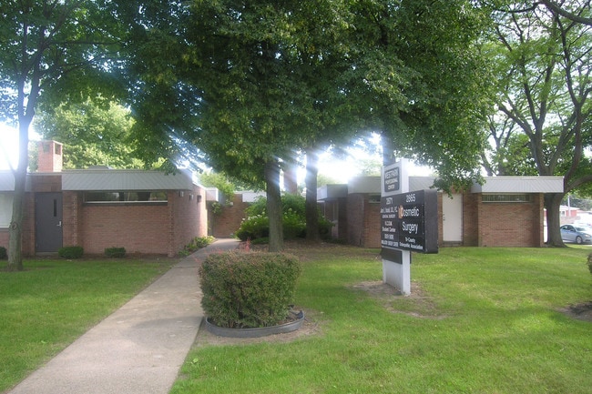
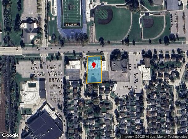
Property Record
2871 West Rd, Trenton, MI 48183

NEARBY LISTINGS FOR SALE OR LEASE
Property Detail
2871 West Rd
Detroit-Warren-Dearborn, MI
Bates Meadows
54-020-04-0157-000
24G157 158 LOT 157 AND 158 BATES MEADOWS SUB T4S R10E L77 P16 WCR
Dentalbldg
Wayne
X
Michigan
26163C0414E
157-158
2024
0.75 AC
2025
Downriver South
594300
Detroit
6,555 SF
DEMOGRAPHICS near 2871 West Rd
1 Mile
3 Mile
5 Mile
2024 Total Population
11,171
50,267
115,615
2029 Population
10,688
48,158
110,914
Pop Growth 2024-2029
(4.32%)
(4.20%)
(4.07%)
Average Age
44
44
43
2024 Total Households
4,767
21,490
48,630
HH Growth 2024-2029
(4.38%)
(4.22%)
(4.11%)
Median Household Inc
$79,703
$75,974
$73,920
Avg Household Size
2.30
2.30
2.30
2024 Avg HH Vehicles
2.00
2.00
2.00
Median Home Value
$182,159
$208,297
$193,288
Median Year Built
1958
1971
1971
Nearby Places
Map Layers
Map Styles
 Street
 Aerial
- Restaurants
- Banks
- Shops
- Fitness
- Groceries
PUBLIC TRANSPORTATION
AIRPORT
Detroit Metro Wayne County
DRIVE
WALK
Distance
Detroit Metro Wayne County
28 min
15.0 mi
Windsor International
DRIVE
WALK
Distance
Windsor International
48 min
29.3 mi
Freight Ports
DRIVE
WALK
Distance
58 min
43.9 mi
SALE & LEASE HISTORY
LISTING DATE
SALE/LEASE

Oct 12, 2016
For Sale
Mar 14, 2019
For Lease
Jun 04, 2018
For Sale
Nearby Properties
Address
Land Use
TOTAL SIZE
Lot Size
Zoning
Address
Land Use
TOTAL SIZE
Lot Size
Zoning
2,651,867 SF
137.23 AC
I-3
Address
Land Use
TOTAL SIZE
Lot Size
Zoning
1,981,391 SF
166.35 AC
I-2
Address
Land Use
TOTAL SIZE
Lot Size
Zoning
2,193,696 SF
182.23 AC
Address
Land Use
TOTAL SIZE
Lot Size
Zoning
155,600 SF
83.84 AC
R1
Address
Land Use
TOTAL SIZE
Lot Size
Zoning
235,489 SF
23.47 AC
Address
Land Use
TOTAL SIZE
Lot Size
Zoning
729,040 SF
45.85 AC
I-2
Address
Land Use
TOTAL SIZE
Lot Size
Zoning
150,224 SF
15.45 AC
RM-1
Address
Land Use
TOTAL SIZE
Lot Size
Zoning
247,238 SF
21.39 AC
I-1
Address
Land Use
TOTAL SIZE
Lot Size
Zoning
35.50 AC
RM-1
Address
Land Use
TOTAL SIZE
Lot Size
Zoning
122,430 SF
22.24 AC
Address
Land Use
TOTAL SIZE
Lot Size
Zoning
209,221 SF
21.80 AC
Address
Land Use
TOTAL SIZE
Lot Size
Zoning
211,389 SF
41.38 AC
Address
Land Use
TOTAL SIZE
Lot Size
Zoning
42.98 AC
Address
Land Use
TOTAL SIZE
Lot Size
Zoning
252,833 SF
34.40 AC
RM1-MUL
Address
Land Use
TOTAL SIZE
Lot Size
Zoning
203,114 SF
14.50 AC
R-M MUL
Address
Land Use
TOTAL SIZE
Lot Size
Zoning
178,682 SF
19.23 AC
Address
Land Use
TOTAL SIZE
Lot Size
Zoning
92,397 SF
12.63 AC
PUD
Address
Land Use
TOTAL SIZE
Lot Size
Zoning
125,828 SF
8.17 AC
B-2 COM
Address
Land Use
TOTAL SIZE
Lot Size
Zoning
2,160 SF
334.88 AC
I1
Address
Land Use
TOTAL SIZE
Lot Size
Zoning
143,496 SF
3.73 AC
RM-2
Address
Land Use
TOTAL SIZE
Lot Size
Zoning
255,456 SF
7.74 AC
I-1
Address
Land Use
TOTAL SIZE
Lot Size
Zoning
61,784 SF
6.78 AC
Address
Land Use
TOTAL SIZE
Lot Size
Zoning
167,004 SF
19.04 AC
RM-1
Address
Land Use
TOTAL SIZE
Lot Size
Zoning
169,192 SF
11.90 AC
R1
Address
Land Use
TOTAL SIZE
Lot Size
Zoning
59,427 SF
5.50 AC
Address
Land Use
TOTAL SIZE
Lot Size
Zoning
68,409 SF
64.56 AC
Address
Land Use
TOTAL SIZE
Lot Size
Zoning
196,714 SF
20.43 AC
Address
Land Use
TOTAL SIZE
Lot Size
Zoning
2,368 SF
32.58 AC
Address
Land Use
TOTAL SIZE
Lot Size
Zoning
301,644 SF
14.22 AC
I-1
Address
Land Use
TOTAL SIZE
Lot Size
Zoning
48,760 SF
4.86 AC
The World's #1 Commercial Real Estate Marketplace
Connect with us
© 2025 CoStar Group
The information above has been obtained from sources believed reliable. While we do not doubt its accuracy we have not verified it and make no guarantee, warranty or representation about it. It is your responsibility to independently confirm its accuracy and completeness. Any projections, opinions, assumptions, or estimates used are for example only and do not represent the current or future performance of the property. The value of this transaction to you depends on tax and other factors which should be evaluated by your tax, financial, and legal advisors. You and your advisors should conduct a careful, independent investigation of the property to determine to your satisfaction the suitability of the property for your needs.