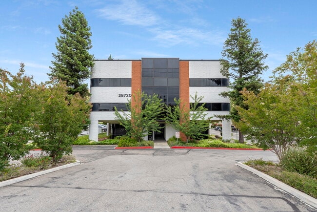
Property Record
28720 Roadside Dr, Agoura Hills, CA 91301


Current Lease Availabilities
NEARBY LISTINGS FOR SALE OR LEASE
Property Detail
28720 Roadside Dr
2061-007-040
LICENSED SURVEYORS MAP AS PER BK 15 PG 8-9 OF L S THAT PART S OF VENTURA FRWY (PER F M 12017) AND N OF CHESEBORO CANYON (PER F M 21218-1-13) OF LOT 22
Officebuilding
Los Angeles
X
California
06111C0995E
22
2024
2.49 AC
2025
Calabasas/Westlake Vill
800336
Los Angeles
93,957 SF
Los Angeles-Long Beach-Glendale, CA
DEMOGRAPHICS near 28720 Roadside Dr
1 Mile
3 Mile
5 Mile
2024 Total Population
5,789
35,078
65,522
2029 Population
5,620
34,031
63,817
Pop Growth 2024-2029
(2.92%)
(2.98%)
(2.60%)
Average Age
43
43
44
2024 Total Households
2,240
13,093
25,348
HH Growth 2024-2029
(3.08%)
(3.19%)
(2.76%)
Median Household Inc
$117,225
$140,856
$142,185
Avg Household Size
2.50
2.70
2.60
2024 Avg HH Vehicles
2.00
2.00
2.00
Median Home Value
$880,971
$904,759
$1,001,320
Median Year Built
1979
1982
1982
Nearby Places
Map Layers
Map Styles
 Street
 Aerial
- Restaurants
- Banks
- Shops
- Fitness
- Groceries
PUBLIC TRANSPORTATION
AIRPORT
Bob Hope
DRIVE
WALK
Distance
Bob Hope
37 min
26.9 mi
Los Angeles International
DRIVE
WALK
Distance
Los Angeles International
47 min
35.1 mi
Freight Ports
The Port of Hueneme
DRIVE
WALK
Distance
The Port of Hueneme
43 min
30.1 mi
Nearby Properties
Address
Land Use
TOTAL SIZE
Lot Size
Zoning
Address
Land Use
TOTAL SIZE
Lot Size
Zoning
294,536 SF
16.70 AC
CS R-MF*
Address
Land Use
TOTAL SIZE
Lot Size
Zoning
142,150 SF
15.35 AC
AH SP*
Address
Land Use
TOTAL SIZE
Lot Size
Zoning
210,268 SF
13.77 AC
CS R-MF*
Address
Land Use
TOTAL SIZE
Lot Size
Zoning
736,464 SF
19.64 AC
WVM1*
Address
Land Use
TOTAL SIZE
Lot Size
Zoning
163,773 SF
5.80 AC
Address
Land Use
TOTAL SIZE
Lot Size
Zoning
142,738 SF
5.56 AC
AH BP-M-FC
Address
Land Use
TOTAL SIZE
Lot Size
Zoning
198,668 SF
17.98 AC
CSCB*
Address
Land Use
TOTAL SIZE
Lot Size
Zoning
142,578 SF
6.13 AC
Address
Land Use
TOTAL SIZE
Lot Size
Zoning
169,597 SF
7.19 AC
AH SP*
Address
Land Use
TOTAL SIZE
Lot Size
Zoning
116,906 SF
6.35 AC
LCA21*
Address
Land Use
TOTAL SIZE
Lot Size
Zoning
201,223 SF
6.94 AC
LCA21*
Address
Land Use
TOTAL SIZE
Lot Size
Zoning
138,762 SF
8.69 AC
LCA21*
Address
Land Use
TOTAL SIZE
Lot Size
Zoning
110,229 SF
5.31 AC
CSCB
Address
Land Use
TOTAL SIZE
Lot Size
Zoning
230,800 SF
4.39 AC
LCMP
Address
Land Use
TOTAL SIZE
Lot Size
Zoning
98,127 SF
2.56 AC
AHRA20000*
Address
Land Use
TOTAL SIZE
Lot Size
Zoning
230,960 SF
6.99 AC
WVM1*
Address
Land Use
TOTAL SIZE
Lot Size
Zoning
115,790 SF
5.41 AC
WVM1*
Address
Land Use
TOTAL SIZE
Lot Size
Zoning
86,558 SF
8.83 AC
AHC3*
Address
Land Use
TOTAL SIZE
Lot Size
Zoning
117,968 SF
6.19 AC
AH BP-M-FC
Address
Land Use
TOTAL SIZE
Lot Size
Zoning
71,159 SF
5.74 AC
AH BP-OR-F
Address
Land Use
TOTAL SIZE
Lot Size
Zoning
65,546 SF
4.08 AC
LCA21*
Address
Land Use
TOTAL SIZE
Lot Size
Zoning
104,838 SF
2.41 AC
CSCR-SC*
Address
Land Use
TOTAL SIZE
Lot Size
Zoning
94,555 SF
3.28 AC
CRS
Address
Land Use
TOTAL SIZE
Lot Size
Zoning
137,738 SF
10.29 AC
LCA21*
Address
Land Use
TOTAL SIZE
Lot Size
Zoning
69,148 SF
3.08 AC
LCA21*
Address
Land Use
TOTAL SIZE
Lot Size
Zoning
157,896 SF
5.74 AC
AH
Address
Land Use
TOTAL SIZE
Lot Size
Zoning
58,092 SF
3.95 AC
AHCRS-FC-O
Address
Land Use
TOTAL SIZE
Lot Size
Zoning
113,871 SF
2.24 AC
LCA21*
Address
Land Use
TOTAL SIZE
Lot Size
Zoning
50,220 SF
4.62 AC
LCA2
Address
Land Use
TOTAL SIZE
Lot Size
Zoning
120,006 SF
6.30 AC
AH BP-M-FC
The World's #1 Commercial Real Estate Marketplace
Connect with us
© 2025 CoStar Group
The information above has been obtained from sources believed reliable. While we do not doubt its accuracy we have not verified it and make no guarantee, warranty or representation about it. It is your responsibility to independently confirm its accuracy and completeness. Any projections, opinions, assumptions, or estimates used are for example only and do not represent the current or future performance of the property. The value of this transaction to you depends on tax and other factors which should be evaluated by your tax, financial, and legal advisors. You and your advisors should conduct a careful, independent investigation of the property to determine to your satisfaction the suitability of the property for your needs.