Property Record
2874 Port Sheldon St, Hudsonville, MI 49426
NEARBY LISTINGS FOR SALE OR LEASE
-
-
View all Hudsonville listings for sale on LoopNet.com
Property Detail
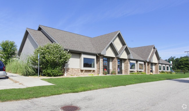
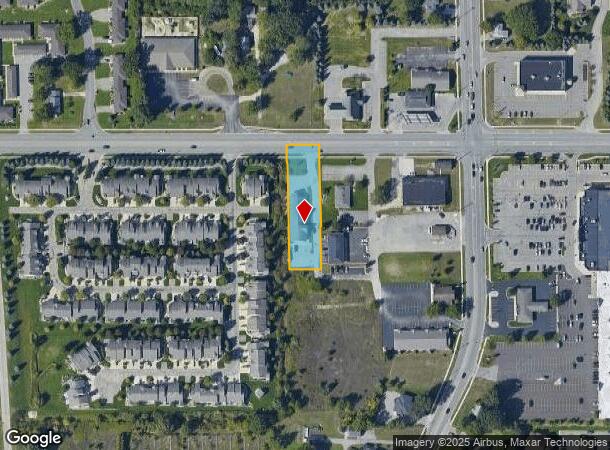
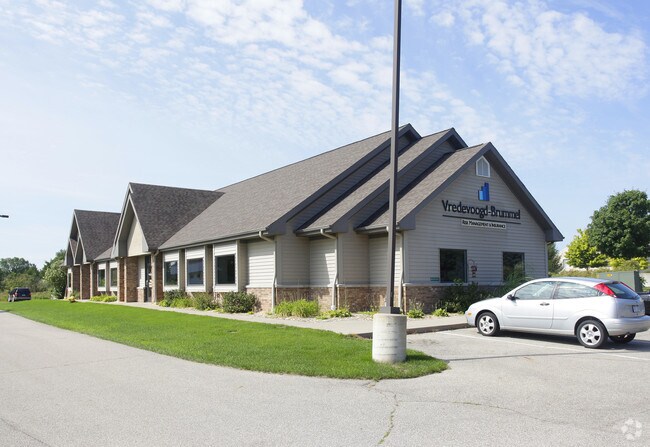
2874 Port Sheldon St
70-14-21-300-112
PART OF SW 1/4 COM S 1/4 COR, TH N 0D 0M 15S E 8091 FT TO CEN LI OF PORT SHELDON ST, TH N 88D 42M 09S W 4465 FT ALG SD CEN LI
Stripcommercialcenter
Ottawa
X
Michigan
26081C0400D
0.67 AC
2024
E Ottawa Cnty/Hudsonville
2025
West Michigan
021802
Grand Rapids-Wyoming, MI
5,680 SF
DEMOGRAPHICS near 2874 Port Sheldon St
1 Mile
3 Mile
5 Mile
2024 Total Population
7,276
52,309
85,011
2029 Population
7,618
54,928
88,732
Pop Growth 2024-2029
+ 4.70%
+ 5.01%
+ 4.38%
Average Age
37
38
38
2024 Total Households
2,415
18,049
30,013
HH Growth 2024-2029
+ 4.80%
+ 5.12%
+ 4.41%
Median Household Inc
$95,126
$91,873
$88,456
Avg Household Size
3.00
2.80
2.80
2024 Avg HH Vehicles
2.00
2.00
2.00
Median Home Value
$260,723
$265,679
$269,996
Median Year Built
1991
1987
1986
Nearby Places
Map Layers
Map Styles
 Street
 Aerial
- Restaurants
- Banks
- Shops
- Fitness
- Groceries
PUBLIC TRANSPORTATION
AIRPORT
Gerald R Ford International
DRIVE
WALK
Distance
Gerald R Ford International
32 min
18.3 mi
Freight Ports
Port Milwaukee
DRIVE
WALK
Distance
Port Milwaukee
295 min
251.1 mi
Nearby Properties
Address
Land Use
TOTAL SIZE
Lot Size
Zoning
Address
Land Use
TOTAL SIZE
Lot Size
Zoning
20.61 AC
HDR
Address
Land Use
TOTAL SIZE
Lot Size
Zoning
114,312 SF
22.23 AC
R-4
Address
Land Use
TOTAL SIZE
Lot Size
Zoning
116,088 SF
29.18 AC
N/A
Address
Land Use
TOTAL SIZE
Lot Size
Zoning
60,000 SF
18.36 AC
I-1
Address
Land Use
TOTAL SIZE
Lot Size
Zoning
103,308 SF
18.76 AC
N/A
Address
Land Use
TOTAL SIZE
Lot Size
Zoning
74.03 AC
MHP
Address
Land Use
TOTAL SIZE
Lot Size
Zoning
83,640 SF
R-1-A
Address
Land Use
TOTAL SIZE
Lot Size
Zoning
Address
Land Use
TOTAL SIZE
Lot Size
Zoning
124,950 SF
18.30 AC
MHR
Address
Land Use
TOTAL SIZE
Lot Size
Zoning
66,766 SF
R-1-A
Address
Land Use
TOTAL SIZE
Lot Size
Zoning
139,774 SF
10.67 AC
HDR-B
Address
Land Use
TOTAL SIZE
Lot Size
Zoning
82,554 SF
5.56 AC
HDR
Address
Land Use
TOTAL SIZE
Lot Size
Zoning
56,784 SF
7.93 AC
R-4
Address
Land Use
TOTAL SIZE
Lot Size
Zoning
47,386 SF
6.93 AC
LDR
Address
Land Use
TOTAL SIZE
Lot Size
Zoning
71,102 SF
8.65 AC
MHR
Address
Land Use
TOTAL SIZE
Lot Size
Zoning
78,846 SF
8.73 AC
I
Address
Land Use
TOTAL SIZE
Lot Size
Zoning
8,448 SF
2.68 AC
R-4
Address
Land Use
TOTAL SIZE
Lot Size
Zoning
78,392 SF
10.45 AC
I-2
Address
Land Use
TOTAL SIZE
Lot Size
Zoning
38,017 SF
5.46 AC
HC
Address
Land Use
TOTAL SIZE
Lot Size
Zoning
103,976 SF
8.68 AC
IND-G
Address
Land Use
TOTAL SIZE
Lot Size
Zoning
28,526 SF
3.39 AC
HC
Address
Land Use
TOTAL SIZE
Lot Size
Zoning
66,980 SF
LDR
Address
Land Use
TOTAL SIZE
Lot Size
Zoning
28,912 SF
5.31 AC
I-2
Address
Land Use
TOTAL SIZE
Lot Size
Zoning
51,000 SF
4.25 AC
I-1
Address
Land Use
TOTAL SIZE
Lot Size
Zoning
44,400 SF
6.69 AC
HS
Address
Land Use
TOTAL SIZE
Lot Size
Zoning
32,576 SF
2.23 AC
PF
Address
Land Use
TOTAL SIZE
Lot Size
Zoning
84,528 SF
6.13 AC
I-1
Address
Land Use
TOTAL SIZE
Lot Size
Zoning
41,221 SF
8.22 AC
HC
Address
Land Use
TOTAL SIZE
Lot Size
Zoning
94,894 SF
7.35 AC
I
Address
Land Use
TOTAL SIZE
Lot Size
Zoning
28,550 SF
8.52 AC
I-1
The World's #1 Commercial Real Estate Marketplace
Connect with us
© 2025 CoStar Group
The information above has been obtained from sources believed reliable. While we do not doubt its accuracy we have not verified it and make no guarantee, warranty or representation about it. It is your responsibility to independently confirm its accuracy and completeness. Any projections, opinions, assumptions, or estimates used are for example only and do not represent the current or future performance of the property. The value of this transaction to you depends on tax and other factors which should be evaluated by your tax, financial, and legal advisors. You and your advisors should conduct a careful, independent investigation of the property to determine to your satisfaction the suitability of the property for your needs.