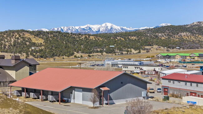
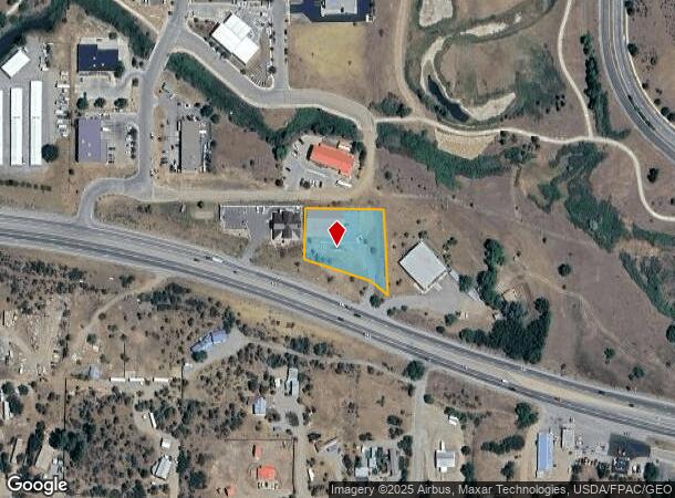
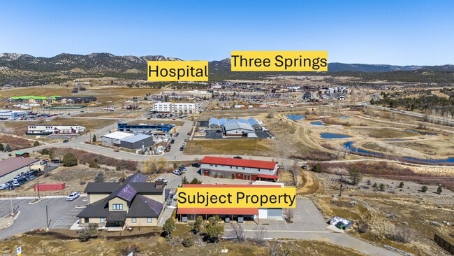
Property Record
28745 Highway 160, Durango, CO 81301
Property Detail
28745 Highway 160
R016816
Durango
Industrialgeneral
SECTION: 11 TOWNSHIP: 34 RANGE: 9 NE/4 NW/4 28745 E US HWY 160 DURANGO 81301
X
La Plata
08067C0705G
Colorado
2024
1.70 AC
2025
Colorado Southwest Area
970703
Other Market Areas
5,000 SF
Durango, CO
NEARBY LISTINGS FOR SALE OR LEASE
DEMOGRAPHICS near 28745 Highway 160
1 mile
3 mile
5 mile
2024 Total Population
1,971
4,766
17,316
2029 Population
2,078
4,921
17,801
Pop Growth 2024-2029
+ 5.43%
+ 3.25%
+ 2.80%
Average Age
41
41
39
2024 Total Households
849
2,030
7,053
HH Growth 2024-2029
+ 5.42%
+ 3.25%
+ 2.54%
Median Household Inc
$68,382
$68,544
$76,592
Avg Household Size
2.30
2.30
2.20
2024 Avg HH Vehicles
2.00
2.00
2.00
Median Home Value
$485,848
$486,913
$610,839
Median Year Built
2010
1998
1987
Nearby Places
Map Layers
Map Styles
 Street
 Aerial
Transit
 Traffic
 Biking
Places
Listings with unknown addresses are not visible on the map
- Restaurants
- Banks
- Shops
- Fitness
- Groceries
PUBLIC TRANSPORTATION
AIRPORT
Durango-La Plata County
Drive
Walk
Distance
Durango-La Plata County
15 min
8.9 mi
Freight Ports
Port of San Diego
Drive
Walk
Distance
Port of San Diego
930 min
810.1 mi
SALE & LEASE HISTORY
LISTING DATE
SALE/LEASE

Apr 08, 2025
For Sale
Nearby Properties
Address
Land Use
TOTAL SIZE
Lot Size
Zoning
Address
Land Use
TOTAL SIZE
Lot Size
Zoning
309,540 SF
49.68 AC
Address
Land Use
TOTAL SIZE
Lot Size
Zoning
151,412 SF
2.60 AC
Address
Land Use
TOTAL SIZE
Lot Size
Zoning
108,918 SF
27.44 AC
Address
Land Use
TOTAL SIZE
Lot Size
Zoning
30,443 SF
0.65 AC
Address
Land Use
TOTAL SIZE
Lot Size
Zoning
108,697 SF
13.51 AC
Address
Land Use
TOTAL SIZE
Lot Size
Zoning
180,591 SF
13.50 AC
Address
Land Use
TOTAL SIZE
Lot Size
Zoning
48,369 SF
0.63 AC
Address
Land Use
TOTAL SIZE
Lot Size
Zoning
58,393 SF
10.20 AC
Address
Land Use
TOTAL SIZE
Lot Size
Zoning
65,704 SF
2.27 AC
Address
Land Use
TOTAL SIZE
Lot Size
Zoning
60,809 SF
3.02 AC
Address
Land Use
TOTAL SIZE
Lot Size
Zoning
112,292 SF
9.21 AC
Address
Land Use
TOTAL SIZE
Lot Size
Zoning
45,481 SF
5 AC
Address
Land Use
TOTAL SIZE
Lot Size
Zoning
42,714 SF
2.05 AC
Address
Land Use
TOTAL SIZE
Lot Size
Zoning
93,332 SF
10.49 AC
Address
Land Use
TOTAL SIZE
Lot Size
Zoning
249,638 SF
18.95 AC
Address
Land Use
TOTAL SIZE
Lot Size
Zoning
10,928 SF
15.53 AC
Address
Land Use
TOTAL SIZE
Lot Size
Zoning
33,837 SF
5 AC
Address
Land Use
TOTAL SIZE
Lot Size
Zoning
61,035 SF
9.64 AC
Address
Land Use
TOTAL SIZE
Lot Size
Zoning
51,279 SF
2.74 AC
Address
Land Use
TOTAL SIZE
Lot Size
Zoning
35,715 SF
4.82 AC
Address
Land Use
TOTAL SIZE
Lot Size
Zoning
93,696 SF
3.47 AC
Address
Land Use
TOTAL SIZE
Lot Size
Zoning
57,142 SF
5.95 AC
Address
Land Use
TOTAL SIZE
Lot Size
Zoning
38,165 SF
3.48 AC
Address
Land Use
TOTAL SIZE
Lot Size
Zoning
26,379 SF
0.84 AC
Address
Land Use
TOTAL SIZE
Lot Size
Zoning
8,003 SF
1.50 AC
Address
Land Use
TOTAL SIZE
Lot Size
Zoning
30,501 SF
2.09 AC
Address
Land Use
TOTAL SIZE
Lot Size
Zoning
38,434 SF
1.33 AC
Address
Land Use
TOTAL SIZE
Lot Size
Zoning
8,771 SF
2.31 AC
Address
Land Use
TOTAL SIZE
Lot Size
Zoning
25,833 SF
3.67 AC
Address
Land Use
TOTAL SIZE
Lot Size
Zoning
52,185 SF
2.92 AC
The World's #1 Commercial Real Estate Marketplace
Connect with us
© 2026 CoStar Group
The information above has been obtained from sources believed reliable. While we do not doubt its accuracy we have not verified it and make no guarantee, warranty or representation about it. It is your responsibility to independently confirm its accuracy and completeness. Any projections, opinions, assumptions, or estimates used are for example only and do not represent the current or future performance of the property. The value of this transaction to you depends on tax and other factors which should be evaluated by your tax, financial, and legal advisors. You and your advisors should conduct a careful, independent investigation of the property to determine to your satisfaction the suitability of the property for your needs.