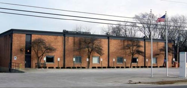
Property Record
28775 N Il Route 83, Mundelein, IL 60060

NEARBY LISTINGS FOR SALE OR LEASE
Property Detail
28775 N Il Route 83
Chicago-Naperville-Elgin, IL-IN
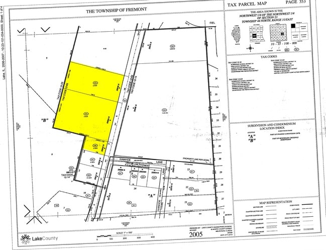
Ivanhoe Sub
10-23-100-062
PT W1/2 NW1/4;LYG ELY OF CLN HWY 83,SLY & WLY OF CLN IVANHOE LN & NLY OF CLN MAPLE LN(EX BEG NWCOR LOT 24 IVANHOE SUB,SL Y 132,ELY 165,SLY 33,ELY TO ELY LN SD LOT,NLY TO NECOR,WL
Industrialgeneral
Lake
X
Illinois
17097C0143L
24
2023
6.23 AC
2024
South Lake County
864105
Chicago
44,965 SF
DEMOGRAPHICS near 28775 N Il Route 83
1 Mile
3 Mile
5 Mile
2024 Total Population
4,446
33,707
116,869
2029 Population
4,393
33,274
115,857
Pop Growth 2024-2029
(1.19%)
(1.28%)
(0.87%)
Average Age
48
42
41
2024 Total Households
1,837
12,191
42,853
HH Growth 2024-2029
(1.36%)
(1.38%)
(0.90%)
Median Household Inc
$115,202
$100,822
$108,342
Avg Household Size
2.40
2.70
2.70
2024 Avg HH Vehicles
2.00
2.00
2.00
Median Home Value
$360,737
$293,175
$327,206
Median Year Built
1997
1989
1988
Nearby Places
Map Layers
Map Styles
 Street
 Aerial
- Restaurants
- Banks
- Shops
- Fitness
- Groceries
PUBLIC TRANSPORTATION
COMMUTER RAIL
Mundelein Station (North Central Service - Northeast Illinois Regional Commuter Railroad (Metra))
DRIVE
WALK
Distance
Mundelein Station (North Central Service - Northeast Illinois Regional Commuter Railroad (Metra))
7 min
3.1 mi
Prairie Crossing Station (Ncs) (North Central Service - Northeast Illinois Regional Commuter Railroad (Metra))
DRIVE
WALK
Distance
Prairie Crossing Station (Ncs) (North Central Service - Northeast Illinois Regional Commuter Railroad (Metra))
6 min
3.5 mi
AIRPORT
Chicago O'Hare International
DRIVE
WALK
Distance
Chicago O'Hare International
42 min
28.2 mi
Freight Ports
Port Milwaukee
DRIVE
WALK
Distance
Port Milwaukee
70 min
56.4 mi
Nearby Properties
Address
Land Use
TOTAL SIZE
Lot Size
Zoning
Address
Land Use
TOTAL SIZE
Lot Size
Zoning
1,401,971 SF
85.78 AC
Address
Land Use
TOTAL SIZE
Lot Size
Zoning
Address
Land Use
TOTAL SIZE
Lot Size
Zoning
596,712 SF
35.56 AC
Address
Land Use
TOTAL SIZE
Lot Size
Zoning
Address
Land Use
TOTAL SIZE
Lot Size
Zoning
2.60 AC
Address
Land Use
TOTAL SIZE
Lot Size
Zoning
340,535 SF
19.01 AC
Address
Land Use
TOTAL SIZE
Lot Size
Zoning
177,993 SF
10 AC
Address
Land Use
TOTAL SIZE
Lot Size
Zoning
135,180 SF
22.05 AC
Address
Land Use
TOTAL SIZE
Lot Size
Zoning
217,620 SF
13.07 AC
Address
Land Use
TOTAL SIZE
Lot Size
Zoning
Address
Land Use
TOTAL SIZE
Lot Size
Zoning
Address
Land Use
TOTAL SIZE
Lot Size
Zoning
192,330 SF
10.23 AC
Address
Land Use
TOTAL SIZE
Lot Size
Zoning
786,312 SF
14.74 AC
Address
Land Use
TOTAL SIZE
Lot Size
Zoning
175,833 SF
7.70 AC
Address
Land Use
TOTAL SIZE
Lot Size
Zoning
175,818 SF
18 AC
Address
Land Use
TOTAL SIZE
Lot Size
Zoning
324,153 SF
12.88 AC
Address
Land Use
TOTAL SIZE
Lot Size
Zoning
428,703 SF
24.63 AC
Address
Land Use
TOTAL SIZE
Lot Size
Zoning
4.88 AC
Address
Land Use
TOTAL SIZE
Lot Size
Zoning
71,320 SF
26.33 AC
Address
Land Use
TOTAL SIZE
Lot Size
Zoning
Address
Land Use
TOTAL SIZE
Lot Size
Zoning
Address
Land Use
TOTAL SIZE
Lot Size
Zoning
95,180 SF
12.40 AC
Address
Land Use
TOTAL SIZE
Lot Size
Zoning
Address
Land Use
TOTAL SIZE
Lot Size
Zoning
142,290 SF
10.56 AC
Address
Land Use
TOTAL SIZE
Lot Size
Zoning
12.81 AC
Address
Land Use
TOTAL SIZE
Lot Size
Zoning
6.04 AC
Address
Land Use
TOTAL SIZE
Lot Size
Zoning
Address
Land Use
TOTAL SIZE
Lot Size
Zoning
6.34 AC
Address
Land Use
TOTAL SIZE
Lot Size
Zoning
129,075 SF
8.79 AC
Address
Land Use
TOTAL SIZE
Lot Size
Zoning
79,136 SF
30.10 AC
The World's #1 Commercial Real Estate Marketplace
Connect with us
© 2026 CoStar Group
The information above has been obtained from sources believed reliable. While we do not doubt its accuracy we have not verified it and make no guarantee, warranty or representation about it. It is your responsibility to independently confirm its accuracy and completeness. Any projections, opinions, assumptions, or estimates used are for example only and do not represent the current or future performance of the property. The value of this transaction to you depends on tax and other factors which should be evaluated by your tax, financial, and legal advisors. You and your advisors should conduct a careful, independent investigation of the property to determine to your satisfaction the suitability of the property for your needs.