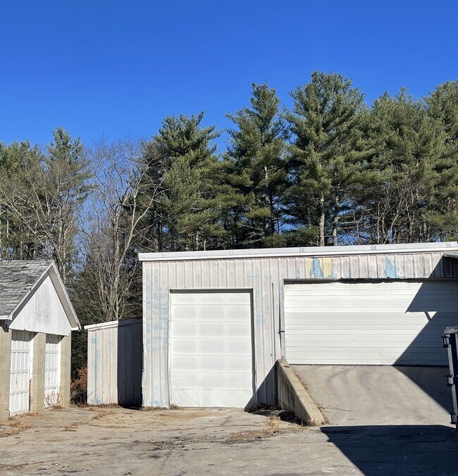
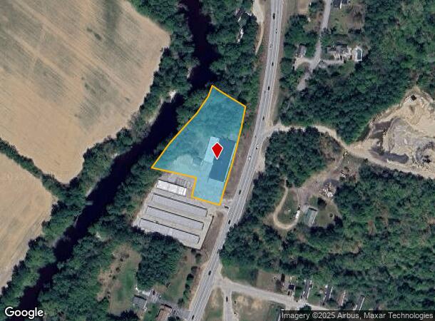
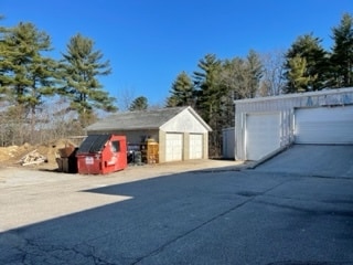
Property Record
288 Pinewood Rd, Allenstown, NH 03275
NEARBY LISTINGS FOR SALE OR LEASE
-
-
View all Allenstown listings for sale on LoopNet.com
Property Detail
288 Pinewood Rd
ALLE-000409-000000-000015
Merrimack
Commercialbuilding
New Hampshire
AE
15
33013C0568E
2.10 AC
2024
Concord/New Hampshire North Area
2024
Other Market Areas
003100
Concord, NH
16,097 SF
DEMOGRAPHICS near 288 Pinewood Rd
1 Mile
3 Mile
5 Mile
2024 Total Population
928
9,535
18,462
2029 Population
981
10,089
19,538
Pop Growth 2024-2029
+ 5.71%
+ 5.81%
+ 5.83%
Average Age
42
42
42
2024 Total Households
354
3,973
7,483
HH Growth 2024-2029
+ 5.65%
+ 5.69%
+ 5.71%
Median Household Inc
$92,360
$74,036
$83,784
Avg Household Size
2.60
2.40
2.40
2024 Avg HH Vehicles
2.00
2.00
2.00
Median Home Value
$210,169
$245,142
$273,828
Median Year Built
1988
1975
1976
Nearby Places
Map Layers
Map Styles
 Street
 Aerial
- Restaurants
- Banks
- Shops
- Fitness
- Groceries
PUBLIC TRANSPORTATION
AIRPORT
Manchester Boston Regional
DRIVE
WALK
Distance
Manchester Boston Regional
39 min
21.3 mi
Freight Ports
Port of Boston
DRIVE
WALK
Distance
Port of Boston
103 min
65.2 mi
SALE & LEASE HISTORY
LISTING DATE
SALE/LEASE

Dec 28, 2022
For Sale
Nearby Properties
Address
Land Use
TOTAL SIZE
Lot Size
Zoning
Address
Land Use
TOTAL SIZE
Lot Size
Zoning
147,477 SF
41.81 AC
R-1A
Address
Land Use
TOTAL SIZE
Lot Size
Zoning
91,930 SF
59 AC
IND -
Address
Land Use
TOTAL SIZE
Lot Size
Zoning
114,272 SF
12.86 AC
CLI -
Address
Land Use
TOTAL SIZE
Lot Size
Zoning
183.12 AC
OSF -
Address
Land Use
TOTAL SIZE
Lot Size
Zoning
1,912 SF
2,295.68 AC
OSF -
Address
Land Use
TOTAL SIZE
Lot Size
Zoning
213 SF
75 AC
OSF -
Address
Land Use
TOTAL SIZE
Lot Size
Zoning
45,252 SF
41 AC
R-1A
Address
Land Use
TOTAL SIZE
Lot Size
Zoning
37.10 AC
OSF -
Address
Land Use
TOTAL SIZE
Lot Size
Zoning
16,250 SF
1.05 AC
IND -
Address
Land Use
TOTAL SIZE
Lot Size
Zoning
3,005 SF
2.57 AC
B - BU
Address
Land Use
TOTAL SIZE
Lot Size
Zoning
34,468 SF
2.49 AC
R1 - R
Address
Land Use
TOTAL SIZE
Lot Size
Zoning
3,040 SF
20.10 AC
R-1A
Address
Land Use
TOTAL SIZE
Lot Size
Zoning
9,430 SF
20 AC
IND -
Address
Land Use
TOTAL SIZE
Lot Size
Zoning
17,320 SF
2.01 AC
R-1A
Address
Land Use
TOTAL SIZE
Lot Size
Zoning
5,035 SF
6.32 AC
R1 - R
Address
Land Use
TOTAL SIZE
Lot Size
Zoning
3,536 SF
0.14 AC
B-2A
Address
Land Use
TOTAL SIZE
Lot Size
Zoning
2,966 SF
650 AC
OSF -
Address
Land Use
TOTAL SIZE
Lot Size
Zoning
65,839 SF
4.67 AC
B - BU
Address
Land Use
TOTAL SIZE
Lot Size
Zoning
5,760 SF
2.99 AC
R-1A
Address
Land Use
TOTAL SIZE
Lot Size
Zoning
32,689 SF
14.50 AC
CLI -
Address
Land Use
TOTAL SIZE
Lot Size
Zoning
408 SF
PZ
Address
Land Use
TOTAL SIZE
Lot Size
Zoning
18,389 SF
1.47 AC
R1 - R
Address
Land Use
TOTAL SIZE
Lot Size
Zoning
9,962 SF
7.03 AC
R-1A
Address
Land Use
TOTAL SIZE
Lot Size
Zoning
6,713 SF
2.20 AC
IND -
Address
Land Use
TOTAL SIZE
Lot Size
Zoning
24.13 AC
RES/LT
Address
Land Use
TOTAL SIZE
Lot Size
Zoning
11,119 SF
2.41 AC
B - BU
Address
Land Use
TOTAL SIZE
Lot Size
Zoning
3,055 SF
3.60 AC
B - BU
Address
Land Use
TOTAL SIZE
Lot Size
Zoning
2,352 SF
0.53 AC
B-2A
Address
Land Use
TOTAL SIZE
Lot Size
Zoning
12,162 SF
1.40 AC
B - BU
Address
Land Use
TOTAL SIZE
Lot Size
Zoning
3,830 SF
4.30 AC
R-1A
The World's #1 Commercial Real Estate Marketplace
Connect with us
© 2025 CoStar Group
The information above has been obtained from sources believed reliable. While we do not doubt its accuracy we have not verified it and make no guarantee, warranty or representation about it. It is your responsibility to independently confirm its accuracy and completeness. Any projections, opinions, assumptions, or estimates used are for example only and do not represent the current or future performance of the property. The value of this transaction to you depends on tax and other factors which should be evaluated by your tax, financial, and legal advisors. You and your advisors should conduct a careful, independent investigation of the property to determine to your satisfaction the suitability of the property for your needs.