Property Record
288 Route 507, Tafton, PA 18464

NEARBY LISTINGS FOR SALE OR LEASE
-
-
View all Tafton listings for sale on LoopNet.com
Property Detail
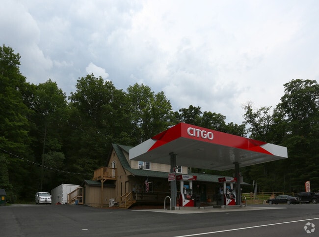
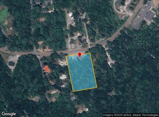
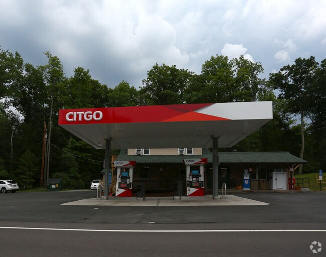
288 Route 507
012044
St Rt 507
Storesoffices
2.70 AC STORE /APT ABOVE
X
Pike
42127C0412D
Pennsylvania
2024
2.70 AC
2025
Pike County
950303
Northern New Jersey
3,236 SF
Newark, NJ-PA
DEMOGRAPHICS near 288 Route 507
1 Mile
3 Mile
5 Mile
2024 Total Population
657
3,428
9,996
2029 Population
735
3,706
10,725
Pop Growth 2024-2029
+ 11.87%
+ 8.11%
+ 7.29%
Average Age
51
50
48
2024 Total Households
304
1,523
4,436
HH Growth 2024-2029
+ 11.84%
+ 8.14%
+ 7.17%
Median Household Inc
$66,111
$56,666
$59,259
Avg Household Size
2.20
2.20
2.20
2024 Avg HH Vehicles
2.00
2.00
2.00
Median Home Value
$267,856
$264,233
$249,448
Median Year Built
1981
1981
1981
Nearby Places
Map Layers
Map Styles
 Street
 Aerial
- Restaurants
- Banks
- Shops
- Fitness
- Groceries
PUBLIC TRANSPORTATION
AIRPORT
Wilkes-Barre/Scranton International
DRIVE
WALK
Distance
Wilkes-Barre/Scranton International
56 min
42.1 mi
Freight Ports
Maher Terminal
DRIVE
WALK
Distance
Maher Terminal
133 min
94.1 mi
Nearby Properties
Address
Land Use
TOTAL SIZE
Lot Size
Zoning
Address
Land Use
TOTAL SIZE
Lot Size
Zoning
13.88 AC
C1
Address
Land Use
TOTAL SIZE
Lot Size
Zoning
0.79 AC
Address
Land Use
TOTAL SIZE
Lot Size
Zoning
11.53 AC
C1
Address
Land Use
TOTAL SIZE
Lot Size
Zoning
235,718 SF
30.55 AC
Address
Land Use
TOTAL SIZE
Lot Size
Zoning
1.20 AC
Address
Land Use
TOTAL SIZE
Lot Size
Zoning
7,840 SF
3,084.93 AC
Address
Land Use
TOTAL SIZE
Lot Size
Zoning
3.29 AC
C1
Address
Land Use
TOTAL SIZE
Lot Size
Zoning
3,360 SF
1.39 AC
Address
Land Use
TOTAL SIZE
Lot Size
Zoning
4.68 AC
C1
Address
Land Use
TOTAL SIZE
Lot Size
Zoning
2.87 AC
C1
Address
Land Use
TOTAL SIZE
Lot Size
Zoning
1.29 AC
Address
Land Use
TOTAL SIZE
Lot Size
Zoning
1.07 AC
Address
Land Use
TOTAL SIZE
Lot Size
Zoning
10.30 AC
S1
Address
Land Use
TOTAL SIZE
Lot Size
Zoning
2.27 AC
C1
Address
Land Use
TOTAL SIZE
Lot Size
Zoning
1.80 AC
Address
Land Use
TOTAL SIZE
Lot Size
Zoning
2,400 SF
1.30 AC
Address
Land Use
TOTAL SIZE
Lot Size
Zoning
3,300 SF
0.93 AC
S1
Address
Land Use
TOTAL SIZE
Lot Size
Zoning
1.55 AC
C1
Address
Land Use
TOTAL SIZE
Lot Size
Zoning
4.10 AC
Address
Land Use
TOTAL SIZE
Lot Size
Zoning
2,480 SF
1.79 AC
Address
Land Use
TOTAL SIZE
Lot Size
Zoning
1.53 AC
C1
Address
Land Use
TOTAL SIZE
Lot Size
Zoning
4,500 SF
3.09 AC
C1
Address
Land Use
TOTAL SIZE
Lot Size
Zoning
4,161 SF
1.99 AC
C1
Address
Land Use
TOTAL SIZE
Lot Size
Zoning
2.62 AC
C1
Address
Land Use
TOTAL SIZE
Lot Size
Zoning
1,508 SF
0.18 AC
RR
Address
Land Use
TOTAL SIZE
Lot Size
Zoning
0.23 AC
RR
Address
Land Use
TOTAL SIZE
Lot Size
Zoning
1,776 SF
0.36 AC
RR
Address
Land Use
TOTAL SIZE
Lot Size
Zoning
0.50 AC
The World's #1 Commercial Real Estate Marketplace
Connect with us
© 2025 CoStar Group
The information above has been obtained from sources believed reliable. While we do not doubt its accuracy we have not verified it and make no guarantee, warranty or representation about it. It is your responsibility to independently confirm its accuracy and completeness. Any projections, opinions, assumptions, or estimates used are for example only and do not represent the current or future performance of the property. The value of this transaction to you depends on tax and other factors which should be evaluated by your tax, financial, and legal advisors. You and your advisors should conduct a careful, independent investigation of the property to determine to your satisfaction the suitability of the property for your needs.