Property Record
2880 Ashley Phosphate Rd, North Charleston, SC 29406

NEARBY LISTINGS FOR SALE OR LEASE
Property Detail
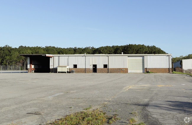
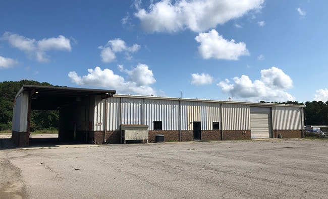
2880 Ashley Phosphate Rd
484-00-00-022
Part Fabian
Warehouse
MAPPLATB L22 MAPPLATP 0319 SUBDIVISIONNAME NORTH CHARLESTON LOT PARCEL A RESIDUAL
X
Charleston
45019C0295K
South Carolina
2025
18.03 AC
2024
North Charleston
003116
Charleston/N Charleston
16,756 SF
Charleston-North Charleston, SC
DEMOGRAPHICS near 2880 Ashley Phosphate Rd
1 Mile
3 Mile
5 Mile
2024 Total Population
7,404
56,766
144,897
2029 Population
7,816
61,521
159,510
Pop Growth 2024-2029
+ 5.56%
+ 8.38%
+ 10.09%
Average Age
36
36
37
2024 Total Households
2,758
22,072
56,029
HH Growth 2024-2029
+ 5.44%
+ 8.20%
+ 9.93%
Median Household Inc
$37,889
$54,888
$61,381
Avg Household Size
2.50
2.50
2.50
2024 Avg HH Vehicles
2.00
2.00
2.00
Median Home Value
$158,515
$221,844
$235,838
Median Year Built
1978
1990
1993
Nearby Places
Map Layers
Map Styles
 Street
 Aerial
- Restaurants
- Banks
- Shops
- Fitness
- Groceries
PUBLIC TRANSPORTATION
AIRPORT
Charleston AFB/International
DRIVE
WALK
Distance
Charleston AFB/International
12 min
5.1 mi
Freight Ports
Georgia Ports - Savannah
DRIVE
WALK
Distance
Georgia Ports - Savannah
1 min
84.5 mi
SALE & LEASE HISTORY
LISTING DATE
SALE/LEASE

Mar 25, 2019
For Lease
Jun 10, 2019
For Lease
Feb 08, 2017
For Lease
Nearby Properties
Address
Land Use
TOTAL SIZE
Lot Size
Zoning
Address
Land Use
TOTAL SIZE
Lot Size
Zoning
48.89 AC
Address
Land Use
TOTAL SIZE
Lot Size
Zoning
2,917 SF
11.76 AC
HANAHAN -
Address
Land Use
TOTAL SIZE
Lot Size
Zoning
Address
Land Use
TOTAL SIZE
Lot Size
Zoning
10,172 SF
12.76 AC
Address
Land Use
TOTAL SIZE
Lot Size
Zoning
7,200 SF
8.73 AC
Address
Land Use
TOTAL SIZE
Lot Size
Zoning
64,584 SF
10.92 AC
HANAHAN -
Address
Land Use
TOTAL SIZE
Lot Size
Zoning
4,320 SF
8.14 AC
HANAHAN -
Address
Land Use
TOTAL SIZE
Lot Size
Zoning
21,364 SF
7.71 AC
Address
Land Use
TOTAL SIZE
Lot Size
Zoning
7,176 SF
3.55 AC
HANAHAN -
Address
Land Use
TOTAL SIZE
Lot Size
Zoning
101,011 SF
6.58 AC
Address
Land Use
TOTAL SIZE
Lot Size
Zoning
199,300 SF
13.28 AC
Address
Land Use
TOTAL SIZE
Lot Size
Zoning
48,885 SF
5.02 AC
Address
Land Use
TOTAL SIZE
Lot Size
Zoning
126,385 SF
13.45 AC
Address
Land Use
TOTAL SIZE
Lot Size
Zoning
14,725 SF
3.55 AC
Address
Land Use
TOTAL SIZE
Lot Size
Zoning
Address
Land Use
TOTAL SIZE
Lot Size
Zoning
133.75 AC
MUC_DC
Address
Land Use
TOTAL SIZE
Lot Size
Zoning
67,082 SF
12.07 AC
Address
Land Use
TOTAL SIZE
Lot Size
Zoning
48,400 SF
5.76 AC
Address
Land Use
TOTAL SIZE
Lot Size
Zoning
167,100 SF
8 AC
Address
Land Use
TOTAL SIZE
Lot Size
Zoning
58,444 SF
5.61 AC
Address
Land Use
TOTAL SIZE
Lot Size
Zoning
44,300 SF
2.34 AC
Address
Land Use
TOTAL SIZE
Lot Size
Zoning
1,925 SF
8.37 AC
HANAHAN -
Address
Land Use
TOTAL SIZE
Lot Size
Zoning
33.88 AC
Address
Land Use
TOTAL SIZE
Lot Size
Zoning
169,262 SF
14.87 AC
Address
Land Use
TOTAL SIZE
Lot Size
Zoning
Address
Land Use
TOTAL SIZE
Lot Size
Zoning
24,648 SF
16.03 AC
HANAHAN -
Address
Land Use
TOTAL SIZE
Lot Size
Zoning
293,825 SF
30.43 AC
Address
Land Use
TOTAL SIZE
Lot Size
Zoning
22,246 SF
5.25 AC
Address
Land Use
TOTAL SIZE
Lot Size
Zoning
30,280 SF
1.71 AC
HANAHAN -
Address
Land Use
TOTAL SIZE
Lot Size
Zoning
1.26 AC
The World's #1 Commercial Real Estate Marketplace
Connect with us
© 2025 CoStar Group
The information above has been obtained from sources believed reliable. While we do not doubt its accuracy we have not verified it and make no guarantee, warranty or representation about it. It is your responsibility to independently confirm its accuracy and completeness. Any projections, opinions, assumptions, or estimates used are for example only and do not represent the current or future performance of the property. The value of this transaction to you depends on tax and other factors which should be evaluated by your tax, financial, and legal advisors. You and your advisors should conduct a careful, independent investigation of the property to determine to your satisfaction the suitability of the property for your needs.