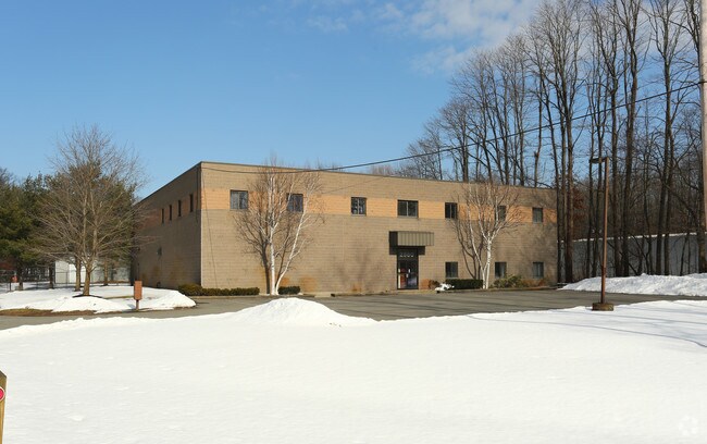
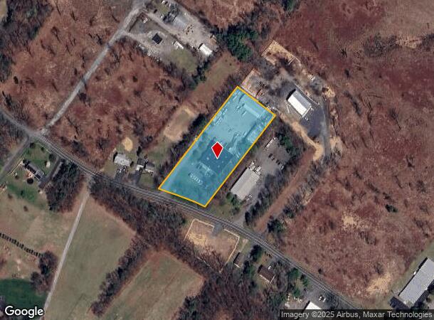
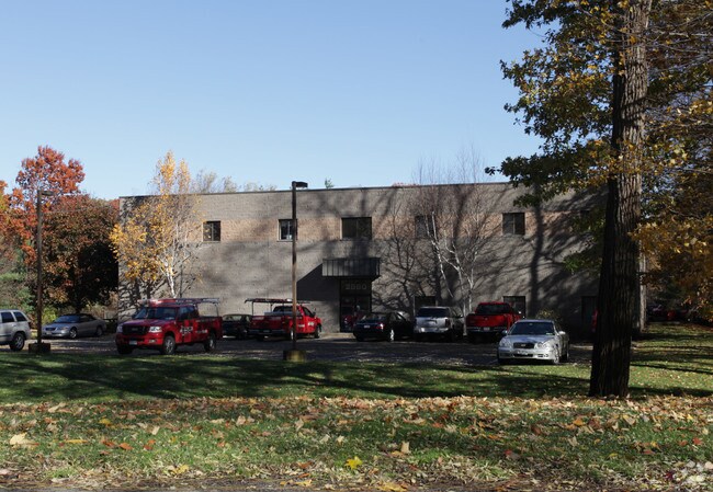
Property Record
2880 Curry Rd, Schenectady, NY 12303
NEARBY LISTINGS FOR SALE OR LEASE
Property Detail
2880 Curry Rd
Albany-Schenectady-Troy, NY
Rose A Caracciolo And Beverly Associates
012689-016-003-0001-014-000-0000
N-2894 E-2886 S-128-40
Warehouse
Albany
X
New York
36001C0156D
14.000
2025
2.26 AC
2024
W Outer Albany County
013804
Albany/Schenectady/Troy
15,000 SF
DEMOGRAPHICS near 2880 Curry Rd
1 Mile
3 Mile
5 Mile
2024 Total Population
1,413
43,688
145,144
2029 Population
1,395
44,648
149,790
Pop Growth 2024-2029
(1.27%)
+ 2.20%
+ 3.20%
Average Age
43
43
41
2024 Total Households
558
18,168
58,856
HH Growth 2024-2029
(1.43%)
+ 2.38%
+ 3.33%
Median Household Inc
$118,014
$86,545
$77,740
Avg Household Size
2.50
2.30
2.30
2024 Avg HH Vehicles
2.00
2.00
2.00
Median Home Value
$307,500
$227,404
$218,500
Median Year Built
1978
1967
1958
Nearby Places
- Restaurants
- Banks
- Shops
- Fitness
- Groceries
PUBLIC TRANSPORTATION
COMMUTER RAIL
DRIVE
WALK
Distance
12 min
6.5 mi
AIRPORT
Albany International
DRIVE
WALK
Distance
Albany International
22 min
9.1 mi
Freight Ports
Albany, NY Port
DRIVE
WALK
Distance
Albany, NY Port
28 min
17.6 mi
SALE & LEASE HISTORY
LISTING DATE
SALE/LEASE

Sep 25, 2016
For Lease
Nearby Properties
Address
Land Use
TOTAL SIZE
Lot Size
Zoning
Address
Land Use
TOTAL SIZE
Lot Size
Zoning
11,700 SF
43.80 AC
R2
Address
Land Use
TOTAL SIZE
Lot Size
Zoning
102,862 SF
32.45 AC
CS
Address
Land Use
TOTAL SIZE
Lot Size
Zoning
120,755 SF
33.88 AC
R1
Address
Land Use
TOTAL SIZE
Lot Size
Zoning
382,858 SF
70.33 AC
R-1
Address
Land Use
TOTAL SIZE
Lot Size
Zoning
98.20 AC
LC
Address
Land Use
TOTAL SIZE
Lot Size
Zoning
9,000 SF
10.32 AC
GB
Address
Land Use
TOTAL SIZE
Lot Size
Zoning
103.30 AC
LC
Address
Land Use
TOTAL SIZE
Lot Size
Zoning
4,680 SF
11.39 AC
CH
Address
Land Use
TOTAL SIZE
Lot Size
Zoning
19,968 SF
12 AC
MR
Address
Land Use
TOTAL SIZE
Lot Size
Zoning
78,326 SF
27.47 AC
R40
Address
Land Use
TOTAL SIZE
Lot Size
Zoning
45 AC
LC
Address
Land Use
TOTAL SIZE
Lot Size
Zoning
Address
Land Use
TOTAL SIZE
Lot Size
Zoning
86,049 SF
17.10 AC
RO30
Address
Land Use
TOTAL SIZE
Lot Size
Zoning
45,896 SF
10.20 AC
03 - MULTI
Address
Land Use
TOTAL SIZE
Lot Size
Zoning
202,050 SF
20.75 AC
B-2
Address
Land Use
TOTAL SIZE
Lot Size
Zoning
79,041 SF
13.20 AC
CN
Address
Land Use
TOTAL SIZE
Lot Size
Zoning
7,216 SF
15.90 AC
03 - MULTI
Address
Land Use
TOTAL SIZE
Lot Size
Zoning
120,373 SF
9.68 AC
CS
Address
Land Use
TOTAL SIZE
Lot Size
Zoning
20,630 SF
12.99 AC
MR*
Address
Land Use
TOTAL SIZE
Lot Size
Zoning
97,440 SF
8.15 AC
B-2
Address
Land Use
TOTAL SIZE
Lot Size
Zoning
111,915 SF
15.04 AC
05 - COMME
Address
Land Use
TOTAL SIZE
Lot Size
Zoning
117 AC
06 - INDUS
Address
Land Use
TOTAL SIZE
Lot Size
Zoning
68,080 SF
6.22 AC
CS
Address
Land Use
TOTAL SIZE
Lot Size
Zoning
30.20 AC
LC
Address
Land Use
TOTAL SIZE
Lot Size
Zoning
68,000 SF
11.20 AC
TH
Address
Land Use
TOTAL SIZE
Lot Size
Zoning
6,889 SF
284.30 AC
F
Address
Land Use
TOTAL SIZE
Lot Size
Zoning
134,624 SF
26.23 AC
CON
Address
Land Use
TOTAL SIZE
Lot Size
Zoning
102,028 SF
11.65 AC
CS
Address
Land Use
TOTAL SIZE
Lot Size
Zoning
32,830 SF
17.85 AC
12
Address
Land Use
TOTAL SIZE
Lot Size
Zoning
47,951 SF
8.10 AC
GB
The World's #1 Commercial Real Estate Marketplace
Connect with us
© 2025 CoStar Group
The information above has been obtained from sources believed reliable. While we do not doubt its accuracy we have not verified it and make no guarantee, warranty or representation about it. It is your responsibility to independently confirm its accuracy and completeness. Any projections, opinions, assumptions, or estimates used are for example only and do not represent the current or future performance of the property. The value of this transaction to you depends on tax and other factors which should be evaluated by your tax, financial, and legal advisors. You and your advisors should conduct a careful, independent investigation of the property to determine to your satisfaction the suitability of the property for your needs.