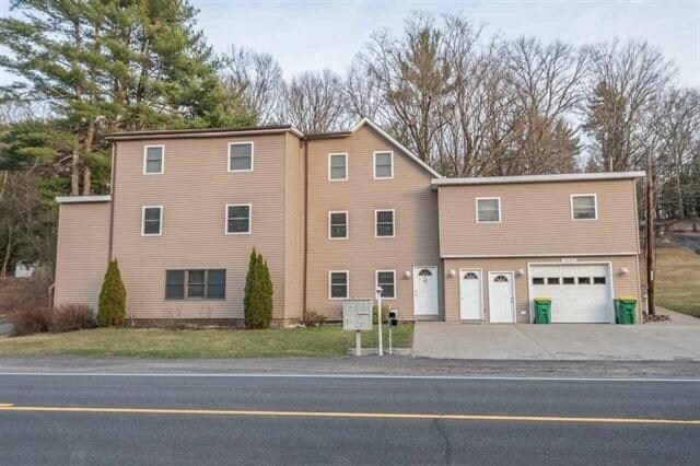
Property Record
2880 Route 32, Kingston, NY 12401
NEARBY LISTINGS FOR SALE OR LEASE
-
-
View all Kingston listings for sale on LoopNet.com
Property Detail
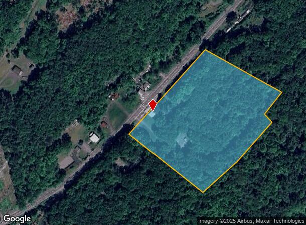
2880 Route 32
515400 56.17-2-15
Ulster
Multifamilydwelling
New York
X
15.000
36111C0470F
8.80 AC
2024
Newburgh/Kingston
2024
Other Market Areas
952400
Kingston, NY
5,436 SF
DEMOGRAPHICS near 2880 Route 32
1 Mile
3 Mile
5 Mile
2024 Total Population
949
23,201
44,160
2029 Population
937
22,995
43,779
Pop Growth 2024-2029
(1.26%)
(0.89%)
(0.86%)
Average Age
45
43
43
2024 Total Households
388
9,899
18,895
HH Growth 2024-2029
(1.55%)
(0.91%)
(0.89%)
Median Household Inc
$70,886
$75,468
$73,291
Avg Household Size
2.40
2.20
2.20
2024 Avg HH Vehicles
2.00
2.00
2.00
Median Home Value
$319,697
$271,774
$261,331
Median Year Built
1958
1955
1955
Nearby Places
- Restaurants
- Banks
- Shops
- Fitness
- Groceries
PUBLIC TRANSPORTATION
AIRPORT
New York Stewart International
DRIVE
WALK
Distance
New York Stewart International
52 min
35.2 mi
Freight Ports
Albany, NY Port
DRIVE
WALK
Distance
Albany, NY Port
70 min
55.7 mi
SALE & LEASE HISTORY
LISTING DATE
SALE/LEASE

Nov 07, 2016
For Sale
Nearby Properties
Address
Land Use
TOTAL SIZE
Lot Size
Zoning
Address
Land Use
TOTAL SIZE
Lot Size
Zoning
21.40 AC
R-1
Address
Land Use
TOTAL SIZE
Lot Size
Zoning
240,924 SF
17 AC
SD
Address
Land Use
TOTAL SIZE
Lot Size
Zoning
181,151 SF
4.90 AC
SD
Address
Land Use
TOTAL SIZE
Lot Size
Zoning
250,613 SF
11.70 AC
SD
Address
Land Use
TOTAL SIZE
Lot Size
Zoning
135,158 SF
31.80 AC
R-1
Address
Land Use
TOTAL SIZE
Lot Size
Zoning
76,788 SF
0.77 AC
T5N
Address
Land Use
TOTAL SIZE
Lot Size
Zoning
143,271 SF
20.40 AC
SD
Address
Land Use
TOTAL SIZE
Lot Size
Zoning
67,180 SF
2.60 AC
T5MS
Address
Land Use
TOTAL SIZE
Lot Size
Zoning
97,636 SF
2.60 AC
T5MS
Address
Land Use
TOTAL SIZE
Lot Size
Zoning
23.30 AC
37
Address
Land Use
TOTAL SIZE
Lot Size
Zoning
8,674 SF
10.90 AC
SD
Address
Land Use
TOTAL SIZE
Lot Size
Zoning
76,577 SF
1.30 AC
T5F
Address
Land Use
TOTAL SIZE
Lot Size
Zoning
10,124 SF
7.50 AC
SD
Address
Land Use
TOTAL SIZE
Lot Size
Zoning
2,670 SF
20.90 AC
SD
Address
Land Use
TOTAL SIZE
Lot Size
Zoning
11,488 SF
10.80 AC
SD
Address
Land Use
TOTAL SIZE
Lot Size
Zoning
50,350 SF
3.70 AC
SD
Address
Land Use
TOTAL SIZE
Lot Size
Zoning
8,400 SF
9 AC
SD
Address
Land Use
TOTAL SIZE
Lot Size
Zoning
47,038 SF
4.96 AC
T5N
Address
Land Use
TOTAL SIZE
Lot Size
Zoning
40,610 SF
1.30 AC
T5MS
Address
Land Use
TOTAL SIZE
Lot Size
Zoning
29,964 SF
5.90 AC
SD
Address
Land Use
TOTAL SIZE
Lot Size
Zoning
64,054 SF
4.70 AC
SD
Address
Land Use
TOTAL SIZE
Lot Size
Zoning
68 AC
RRR
Address
Land Use
TOTAL SIZE
Lot Size
Zoning
1,064 SF
28.96 AC
R12
Address
Land Use
TOTAL SIZE
Lot Size
Zoning
12,771 SF
6.50 AC
SD
Address
Land Use
TOTAL SIZE
Lot Size
Zoning
46,948 SF
17.30 AC
R12
Address
Land Use
TOTAL SIZE
Lot Size
Zoning
89,048 SF
2.02 AC
T5F
Address
Land Use
TOTAL SIZE
Lot Size
Zoning
2,746 SF
51.20 AC
T3L
Address
Land Use
TOTAL SIZE
Lot Size
Zoning
14,759 SF
1.70 AC
T5N
Address
Land Use
TOTAL SIZE
Lot Size
Zoning
11,228 SF
1.90 AC
SD
Address
Land Use
TOTAL SIZE
Lot Size
Zoning
27,609 SF
0.29 AC
T5MS
The World's #1 Commercial Real Estate Marketplace
Connect with us
© 2025 CoStar Group
The information above has been obtained from sources believed reliable. While we do not doubt its accuracy we have not verified it and make no guarantee, warranty or representation about it. It is your responsibility to independently confirm its accuracy and completeness. Any projections, opinions, assumptions, or estimates used are for example only and do not represent the current or future performance of the property. The value of this transaction to you depends on tax and other factors which should be evaluated by your tax, financial, and legal advisors. You and your advisors should conduct a careful, independent investigation of the property to determine to your satisfaction the suitability of the property for your needs.