Property Record
28801 Telegraph Rd, Flat Rock, MI 48134
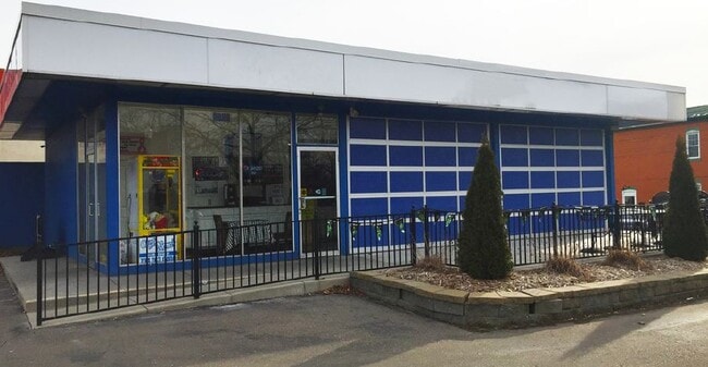

Property Detail
28801 Telegraph Rd
Detroit-Warren-Dearborn, MI
31E109 110 T4S LOTS 109 AND 110 ASSESSORS FLAT ROCK PLAT NO. 4 T4S R10E L67 P44 WCR
58-094-02-0109-000
Wayne
Restaurantdrivein
Michigan
B and X Area of moderate flood hazard, usually the area between the limits of the 100-year and 500-year floods.
109-110
2025
0.23 AC
2025
Downriver South
599100
Detroit
1,247 SF
NEARBY LISTINGS FOR SALE OR LEASE
DEMOGRAPHICS near 28801 Telegraph Rd
1 mile
3 mile
5 mile
2025 Total Population
4,183
28,442
69,821
2030 Population
4,118
28,119
68,918
Pop Growth 2025-2030
(1.55%)
(1.14%)
(1.29%)
Average Age
41
42
42
2025 Total Households
1,624
11,103
27,726
HH Growth 2025-2030
(1.54%)
(1.12%)
(1.33%)
Median Household Inc
$80,991
$86,144
$85,758
Avg Household Size
2.60
2.50
2.50
2025 Avg HH Vehicles
2.00
2.00
2.00
Median Home Value
$292,307
$273,825
$262,622
Median Year Built
1959
1989
1987
Nearby Places
Map Layers
Map Styles
 Street
 Aerial
Layers
 Traffic
 Biking
Places
Listings with unknown addresses are not visible on the map
- Restaurants
- Banks
- Shops
- Fitness
- Groceries
PUBLIC TRANSPORTATION
AIRPORT
Detroit Metro Wayne County
Drive
Walk
Distance
Detroit Metro Wayne County
25 min
15.3 mi
Windsor International
Drive
Walk
Distance
Windsor International
51 min
31.2 mi
Freight Ports
Drive
Walk
Distance
51 min
38.6 mi
SALE & LEASE HISTORY
LISTING DATE
SALE/LEASE

Jan 23, 2020
For Lease
Jan 21, 2020
For Lease
Jan 21, 2020
For Sale
Nearby Properties
Address
Land Use
TOTAL SIZE
Lot Size
Zoning
Address
Land Use
TOTAL SIZE
Lot Size
Zoning
3,189,689 SF
228.88 AC
Address
Land Use
TOTAL SIZE
Lot Size
Zoning
215,724 SF
Address
Land Use
TOTAL SIZE
Lot Size
Zoning
249,836 SF
22.18 AC
AG
Address
Land Use
TOTAL SIZE
Lot Size
Zoning
1,021,918 SF
163.58 AC
Address
Land Use
TOTAL SIZE
Lot Size
Zoning
3,280 SF
99.72 AC
Address
Land Use
TOTAL SIZE
Lot Size
Zoning
33,600 SF
100.03 AC
Address
Land Use
TOTAL SIZE
Lot Size
Zoning
307,181 SF
22.32 AC
Address
Land Use
TOTAL SIZE
Lot Size
Zoning
179,235 SF
25.38 AC
Address
Land Use
TOTAL SIZE
Lot Size
Zoning
95,650 SF
73.78 AC
Address
Land Use
TOTAL SIZE
Lot Size
Zoning
52.37 AC
Address
Land Use
TOTAL SIZE
Lot Size
Zoning
3,520 SF
62.97 AC
MHP MOB
Address
Land Use
TOTAL SIZE
Lot Size
Zoning
3,870 SF
38.38 AC
Address
Land Use
TOTAL SIZE
Lot Size
Zoning
146,300 SF
25.84 AC
Address
Land Use
TOTAL SIZE
Lot Size
Zoning
101,861 SF
15.33 AC
B-2
Address
Land Use
TOTAL SIZE
Lot Size
Zoning
69,938 SF
1.74 AC
Address
Land Use
TOTAL SIZE
Lot Size
Zoning
114,165 SF
13.07 AC
Address
Land Use
TOTAL SIZE
Lot Size
Zoning
124,102 SF
17.09 AC
Address
Land Use
TOTAL SIZE
Lot Size
Zoning
44.13 AC
MHP MOB
Address
Land Use
TOTAL SIZE
Lot Size
Zoning
30,719 SF
9.93 AC
AG AGRI
Address
Land Use
TOTAL SIZE
Lot Size
Zoning
18,520 SF
326.27 AC
Address
Land Use
TOTAL SIZE
Lot Size
Zoning
130,627 SF
20.42 AC
Address
Land Use
TOTAL SIZE
Lot Size
Zoning
40.40 AC
PUD
Address
Land Use
TOTAL SIZE
Lot Size
Zoning
134,191 SF
14.29 AC
Address
Land Use
TOTAL SIZE
Lot Size
Zoning
13.01 AC
RM-1
Address
Land Use
TOTAL SIZE
Lot Size
Zoning
7,222 SF
58.71 AC
Address
Land Use
TOTAL SIZE
Lot Size
Zoning
32,268 SF
4.20 AC
Address
Land Use
TOTAL SIZE
Lot Size
Zoning
7.13 AC
RM-1
Address
Land Use
TOTAL SIZE
Lot Size
Zoning
176,644 SF
8.78 AC
Address
Land Use
TOTAL SIZE
Lot Size
Zoning
1,999 SF
48.96 AC
R-1
Address
Land Use
TOTAL SIZE
Lot Size
Zoning
79,930 SF
6.36 AC
The World's #1 Commercial Real Estate Marketplace
Connect with us
© 2026 CoStar Group
The information above has been obtained from sources believed reliable. While we do not doubt its accuracy we have not verified it and make no guarantee, warranty or representation about it. It is your responsibility to independently confirm its accuracy and completeness. Any projections, opinions, assumptions, or estimates used are for example only and do not represent the current or future performance of the property. The value of this transaction to you depends on tax and other factors which should be evaluated by your tax, financial, and legal advisors. You and your advisors should conduct a careful, independent investigation of the property to determine to your satisfaction the suitability of the property for your needs.