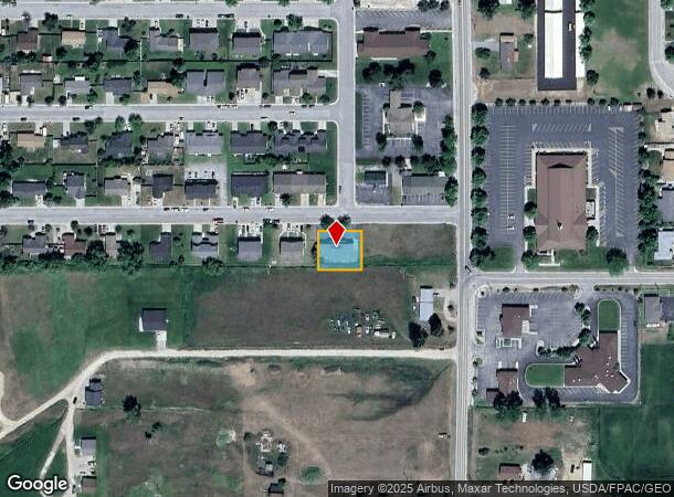
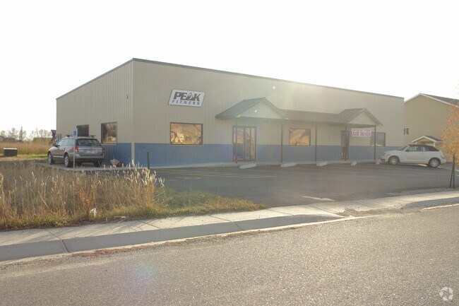
Property Record
2882 Rosemont Loop, Stevensville, MT 59870

NEARBY LISTINGS FOR SALE OR LEASE
Property Detail
2882 Rosemont Loop
13-1764-27-4-01-72-0000
Smith George A Subd
Officebuilding
SMITH GEORGE A SUBD, S27, T09 N, R20 W, 10297 SQUARE FEET, LOT 3 BLOCK 5
X
Ravalli
30081C0215D
Montana
2025
3
2025
0.24 AC
000204
Montana Other Areas
2,688 SF
Other Market Areas
DEMOGRAPHICS near 2882 Rosemont Loop
1 Mile
3 Mile
5 Mile
2024 Total Population
3,414
5,984
8,944
2029 Population
4,097
7,097
10,555
Pop Growth 2024-2029
+ 20.01%
+ 18.60%
+ 18.01%
Average Age
44
46
46
2024 Total Households
1,478
2,573
3,768
HH Growth 2024-2029
+ 20.23%
+ 18.73%
+ 18.15%
Median Household Inc
$48,168
$56,104
$62,104
Avg Household Size
2.30
2.30
2.30
2024 Avg HH Vehicles
2.00
2.00
2.00
Median Home Value
$331,979
$405,742
$421,617
Median Year Built
1987
1988
1987
Nearby Places
Map Layers
Map Styles
 Street
 Aerial
- Restaurants
- Banks
- Shops
- Fitness
- Groceries
PUBLIC TRANSPORTATION
AIRPORT
Missoula Montana
DRIVE
WALK
Distance
Missoula Montana
49 min
33.7 mi
Nearby Properties
Address
Land Use
TOTAL SIZE
Lot Size
Zoning
Address
Land Use
TOTAL SIZE
Lot Size
Zoning
59,096 SF
9.06 AC
Address
Land Use
TOTAL SIZE
Lot Size
Zoning
25,356 SF
2.60 AC
Address
Land Use
TOTAL SIZE
Lot Size
Zoning
16,918 SF
10.54 AC
Address
Land Use
TOTAL SIZE
Lot Size
Zoning
352 SF
7.68 AC
Address
Land Use
TOTAL SIZE
Lot Size
Zoning
26,216 SF
3.72 AC
Address
Land Use
TOTAL SIZE
Lot Size
Zoning
18,054 SF
3.19 AC
Address
Land Use
TOTAL SIZE
Lot Size
Zoning
36,512 SF
3.07 AC
Address
Land Use
TOTAL SIZE
Lot Size
Zoning
15,927 SF
1.16 AC
1
Address
Land Use
TOTAL SIZE
Lot Size
Zoning
7,400 SF
20.88 AC
Address
Land Use
TOTAL SIZE
Lot Size
Zoning
14,429 SF
Address
Land Use
TOTAL SIZE
Lot Size
Zoning
24,646 SF
2.05 AC
Address
Land Use
TOTAL SIZE
Lot Size
Zoning
3,120 SF
12.84 AC
Address
Land Use
TOTAL SIZE
Lot Size
Zoning
10,000 SF
3.12 AC
Address
Land Use
TOTAL SIZE
Lot Size
Zoning
7,309 SF
0.39 AC
Address
Land Use
TOTAL SIZE
Lot Size
Zoning
5,840 SF
0.23 AC
Address
Land Use
TOTAL SIZE
Lot Size
Zoning
3,278 SF
19.42 AC
Address
Land Use
TOTAL SIZE
Lot Size
Zoning
19,910 SF
0.48 AC
1
Address
Land Use
TOTAL SIZE
Lot Size
Zoning
3,093 SF
1.27 AC
Address
Land Use
TOTAL SIZE
Lot Size
Zoning
15,334 SF
2.75 AC
Address
Land Use
TOTAL SIZE
Lot Size
Zoning
10,710 SF
1.62 AC
Address
Land Use
TOTAL SIZE
Lot Size
Zoning
6,720 SF
1.23 AC
Address
Land Use
TOTAL SIZE
Lot Size
Zoning
3,169 SF
0.67 AC
Address
Land Use
TOTAL SIZE
Lot Size
Zoning
7,651 SF
0.63 AC
Address
Land Use
TOTAL SIZE
Lot Size
Zoning
11,520 SF
6.49 AC
Address
Land Use
TOTAL SIZE
Lot Size
Zoning
10,200 SF
37 AC
Address
Land Use
TOTAL SIZE
Lot Size
Zoning
3,600 SF
6.66 AC
Address
Land Use
TOTAL SIZE
Lot Size
Zoning
9,048 SF
1.16 AC
Address
Land Use
TOTAL SIZE
Lot Size
Zoning
9,856 SF
1.28 AC
Address
Land Use
TOTAL SIZE
Lot Size
Zoning
6,400 SF
2 AC
Address
Land Use
TOTAL SIZE
Lot Size
Zoning
3,712 SF
69.75 AC
The World's #1 Commercial Real Estate Marketplace
Connect with us
© 2026 CoStar Group
The information above has been obtained from sources believed reliable. While we do not doubt its accuracy we have not verified it and make no guarantee, warranty or representation about it. It is your responsibility to independently confirm its accuracy and completeness. Any projections, opinions, assumptions, or estimates used are for example only and do not represent the current or future performance of the property. The value of this transaction to you depends on tax and other factors which should be evaluated by your tax, financial, and legal advisors. You and your advisors should conduct a careful, independent investigation of the property to determine to your satisfaction the suitability of the property for your needs.