Property Record
2885 Peck Rd, Pea Ridge, AR 72751

NEARBY LISTINGS FOR SALE OR LEASE
Property Detail
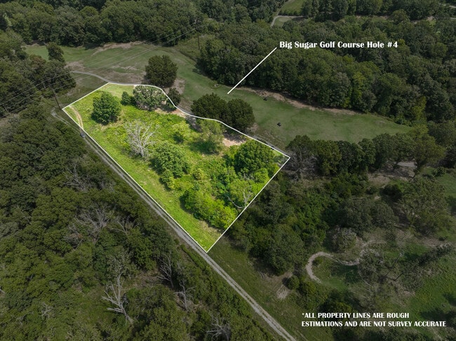
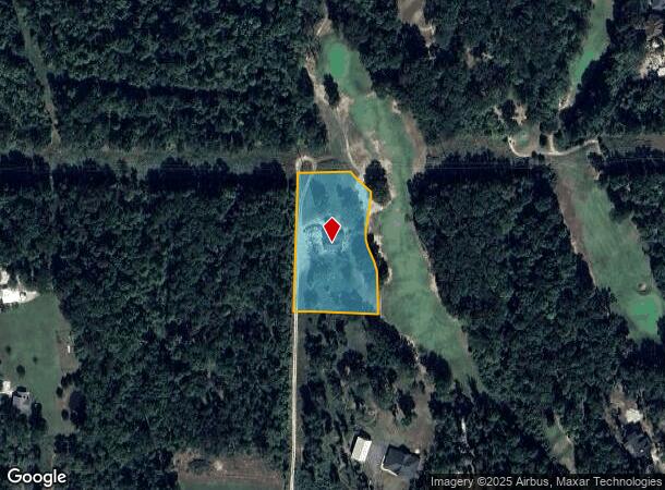
2885 Peck Rd
Fayetteville-Springdale-Rogers, AR-MO
Pea Ridge
13-01204-006
PART OF THE SOUTHWEST QUARTER (SW ) OF THE SOUTHWEST QUARTER (SW ) OF SECTION SEVEN (7), TOWNSHIP TWENTY (20) NORTH, RANGE TWENTY-NINE (29) WEST, BENTON COUNTY, ARKANSAS BEING MORE PARTICULARLY DESCRIBED AS FOLLOWS COMMENCING AT A FOUND IRON PIN FOR
Residentialacreage
Benton
X
Arkansas
05007C0115K
2.02 AC
2025
Outlying Benton County
2025
Fayetteville/Springdale/Rogers
020102
DEMOGRAPHICS near 2885 Peck Rd
1 Mile
3 Mile
5 Mile
2024 Total Population
1,295
12,141
34,907
2029 Population
1,530
14,341
40,950
Pop Growth 2024-2029
+ 18.15%
+ 18.12%
+ 17.31%
Average Age
40
39
38
2024 Total Households
449
4,237
12,363
HH Growth 2024-2029
+ 18.26%
+ 18.13%
+ 17.34%
Median Household Inc
$83,166
$83,023
$77,770
Avg Household Size
2.80
2.80
2.70
2024 Avg HH Vehicles
2.00
2.00
2.00
Median Home Value
$267,187
$241,149
$255,728
Median Year Built
1995
1995
1996
Nearby Places
Map Layers
Map Styles
 Street
 Aerial
- Restaurants
- Banks
- Shops
- Fitness
- Groceries
PUBLIC TRANSPORTATION
AIRPORT
Northwest Arkansas Ntl
DRIVE
WALK
Distance
Northwest Arkansas Ntl
52 min
23.3 mi
SALE & LEASE HISTORY
LISTING DATE
SALE/LEASE

Sep 05, 2024
For Sale
Nearby Properties
Address
Land Use
TOTAL SIZE
Lot Size
Zoning
Address
Land Use
TOTAL SIZE
Lot Size
Zoning
28,501 SF
5.95 AC
Address
Land Use
TOTAL SIZE
Lot Size
Zoning
7,650 SF
5.63 AC
Address
Land Use
TOTAL SIZE
Lot Size
Zoning
41,940 SF
36.20 AC
Address
Land Use
TOTAL SIZE
Lot Size
Zoning
5,936 SF
1.03 AC
Address
Land Use
TOTAL SIZE
Lot Size
Zoning
67,745 SF
4.61 AC
Address
Land Use
TOTAL SIZE
Lot Size
Zoning
6,870 SF
1.66 AC
Address
Land Use
TOTAL SIZE
Lot Size
Zoning
60,356 SF
3.48 AC
Address
Land Use
TOTAL SIZE
Lot Size
Zoning
61,024 SF
4.19 AC
Address
Land Use
TOTAL SIZE
Lot Size
Zoning
58,990 SF
5.70 AC
Address
Land Use
TOTAL SIZE
Lot Size
Zoning
6,088 SF
1.51 AC
Address
Land Use
TOTAL SIZE
Lot Size
Zoning
22,141 SF
2.21 AC
Address
Land Use
TOTAL SIZE
Lot Size
Zoning
2,027 SF
1.07 AC
Address
Land Use
TOTAL SIZE
Lot Size
Zoning
9,541 SF
9.86 AC
Address
Land Use
TOTAL SIZE
Lot Size
Zoning
7,114 SF
1.50 AC
Address
Land Use
TOTAL SIZE
Lot Size
Zoning
20,883 SF
6.35 AC
Address
Land Use
TOTAL SIZE
Lot Size
Zoning
23,814 SF
4.08 AC
Address
Land Use
TOTAL SIZE
Lot Size
Zoning
8,598 SF
0.91 AC
Address
Land Use
TOTAL SIZE
Lot Size
Zoning
39,905 SF
11.04 AC
Address
Land Use
TOTAL SIZE
Lot Size
Zoning
3,960 SF
1.13 AC
Address
Land Use
TOTAL SIZE
Lot Size
Zoning
4,900 SF
10.56 AC
Address
Land Use
TOTAL SIZE
Lot Size
Zoning
13,056 SF
2.41 AC
Address
Land Use
TOTAL SIZE
Lot Size
Zoning
6,811 SF
0.95 AC
Address
Land Use
TOTAL SIZE
Lot Size
Zoning
32,400 SF
7 AC
Address
Land Use
TOTAL SIZE
Lot Size
Zoning
3,667 SF
1.15 AC
Address
Land Use
TOTAL SIZE
Lot Size
Zoning
2,904 SF
0.86 AC
Address
Land Use
TOTAL SIZE
Lot Size
Zoning
6,400 SF
2.86 AC
Address
Land Use
TOTAL SIZE
Lot Size
Zoning
10,920 SF
0.89 AC
Address
Land Use
TOTAL SIZE
Lot Size
Zoning
14,820 SF
1.33 AC
Address
Land Use
TOTAL SIZE
Lot Size
Zoning
7,862 SF
91.40 AC
Address
Land Use
TOTAL SIZE
Lot Size
Zoning
9,666 SF
1.53 AC
The World's #1 Commercial Real Estate Marketplace
Connect with us
© 2025 CoStar Group
The information above has been obtained from sources believed reliable. While we do not doubt its accuracy we have not verified it and make no guarantee, warranty or representation about it. It is your responsibility to independently confirm its accuracy and completeness. Any projections, opinions, assumptions, or estimates used are for example only and do not represent the current or future performance of the property. The value of this transaction to you depends on tax and other factors which should be evaluated by your tax, financial, and legal advisors. You and your advisors should conduct a careful, independent investigation of the property to determine to your satisfaction the suitability of the property for your needs.