Property Record
2885 Roop Rd, Gilroy, CA 95020
NEARBY LISTINGS FOR SALE OR LEASE
Property Detail
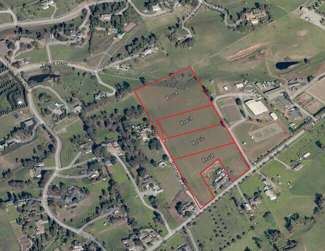
2885 Roop Rd
San Jose-Sunnyvale-Santa Clara, CA
Dunne Ranch 08 Catherine
835-22-012
LOT 3
Residentialacreage
Santa Clara
D
California
06085C0641H
3
2024
2.50 AC
2025
Outlying Santa Clara Cnty
512402
South Bay/San Jose
DEMOGRAPHICS near 2885 Roop Rd
1 Mile
3 Mile
5 Mile
2024 Total Population
737
8,551
60,590
2029 Population
675
8,024
57,890
Pop Growth 2024-2029
(8.41%)
(6.16%)
(4.46%)
Average Age
45
39
38
2024 Total Households
234
2,409
17,587
HH Growth 2024-2029
(8.97%)
(6.68%)
(4.75%)
Median Household Inc
$124,652
$104,179
$109,063
Avg Household Size
3.00
3.30
3.30
2024 Avg HH Vehicles
3.00
3.00
2.00
Median Home Value
$1,117,293
$1,029,640
$838,409
Median Year Built
1975
1978
1984
Nearby Places
Map Layers
Map Styles
 Street
 Aerial
- Restaurants
- Banks
- Shops
- Fitness
- Groceries
PUBLIC TRANSPORTATION
COMMUTER RAIL
Gilroy (Caltrain - Caltrain (Caltrain))
DRIVE
WALK
Distance
Gilroy (Caltrain - Caltrain (Caltrain))
9 min
4.8 mi
Gilroy Caltrain Station Southbound (South Santa Clara County Connector - Caltrain (Caltrain))
DRIVE
WALK
Distance
Gilroy Caltrain Station Southbound (South Santa Clara County Connector - Caltrain (Caltrain))
9 min
4.9 mi
Freight Ports
Port of Redwood City
DRIVE
WALK
Distance
Port of Redwood City
68 min
54.0 mi
SALE & LEASE HISTORY
LISTING DATE
SALE/LEASE

Sep 15, 2023
For Sale
Nearby Properties
Address
Land Use
TOTAL SIZE
Lot Size
Zoning
Address
Land Use
TOTAL SIZE
Lot Size
Zoning
171,339 SF
16.43 AC
C3
Address
Land Use
TOTAL SIZE
Lot Size
Zoning
133,498 SF
12.16 AC
C3
Address
Land Use
TOTAL SIZE
Lot Size
Zoning
113,883 SF
9.63 AC
C1
Address
Land Use
TOTAL SIZE
Lot Size
Zoning
94,345 SF
10.68 AC
C1
Address
Land Use
TOTAL SIZE
Lot Size
Zoning
219,622 SF
19.80 AC
A1-25
Address
Land Use
TOTAL SIZE
Lot Size
Zoning
56.33 AC
M2
Address
Land Use
TOTAL SIZE
Lot Size
Zoning
123,268 SF
7.62 AC
R3
Address
Land Use
TOTAL SIZE
Lot Size
Zoning
72,159 SF
4.16 AC
R3
Address
Land Use
TOTAL SIZE
Lot Size
Zoning
32,727 SF
1.82 AC
M2
Address
Land Use
TOTAL SIZE
Lot Size
Zoning
3.43 AC
APD
Address
Land Use
TOTAL SIZE
Lot Size
Zoning
126,503 SF
4.61 AC
MI
Address
Land Use
TOTAL SIZE
Lot Size
Zoning
59,676 SF
3.53 AC
R-1
Address
Land Use
TOTAL SIZE
Lot Size
Zoning
84,728 SF
6.54 AC
HC
Address
Land Use
TOTAL SIZE
Lot Size
Zoning
130,384 SF
9 AC
A-40A
Address
Land Use
TOTAL SIZE
Lot Size
Zoning
116,035 SF
4.59 AC
M1
Address
Land Use
TOTAL SIZE
Lot Size
Zoning
100,058 SF
9.48 AC
C3
Address
Land Use
TOTAL SIZE
Lot Size
Zoning
26.75 AC
GI
Address
Land Use
TOTAL SIZE
Lot Size
Zoning
71,730 SF
4.48 AC
M1
Address
Land Use
TOTAL SIZE
Lot Size
Zoning
6.02 AC
M2
Address
Land Use
TOTAL SIZE
Lot Size
Zoning
125,597 SF
13.70 AC
C3
Address
Land Use
TOTAL SIZE
Lot Size
Zoning
62,360 SF
4.50 AC
M2
Address
Land Use
TOTAL SIZE
Lot Size
Zoning
36,593 SF
2.57 AC
C
Address
Land Use
TOTAL SIZE
Lot Size
Zoning
65,250 SF
4.25 AC
M
Address
Land Use
TOTAL SIZE
Lot Size
Zoning
70,716 SF
5.15 AC
M2
Address
Land Use
TOTAL SIZE
Lot Size
Zoning
39,342 SF
3.51 AC
M2
Address
Land Use
TOTAL SIZE
Lot Size
Zoning
26,264 SF
1.51 AC
CM
Address
Land Use
TOTAL SIZE
Lot Size
Zoning
69,080 SF
6.25 AC
C1
Address
Land Use
TOTAL SIZE
Lot Size
Zoning
24.54 AC
AW
Address
Land Use
TOTAL SIZE
Lot Size
Zoning
12,914 SF
1.96 AC
HC
Address
Land Use
TOTAL SIZE
Lot Size
Zoning
12,000 SF
3.94 AC
A1-25
The World's #1 Commercial Real Estate Marketplace
Connect with us
© 2025 CoStar Group
The information above has been obtained from sources believed reliable. While we do not doubt its accuracy we have not verified it and make no guarantee, warranty or representation about it. It is your responsibility to independently confirm its accuracy and completeness. Any projections, opinions, assumptions, or estimates used are for example only and do not represent the current or future performance of the property. The value of this transaction to you depends on tax and other factors which should be evaluated by your tax, financial, and legal advisors. You and your advisors should conduct a careful, independent investigation of the property to determine to your satisfaction the suitability of the property for your needs.