Property Record
2885 W Superstition Blvd, Apache Junction, AZ 85120
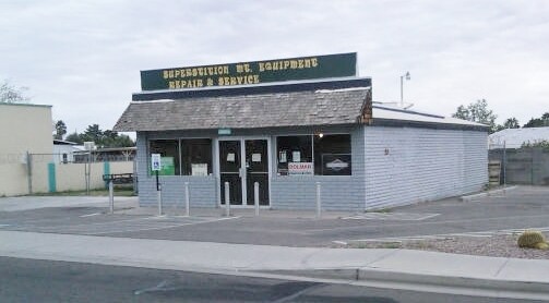

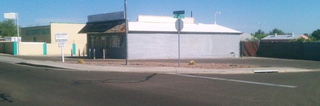
Property Detail
2885 W Superstition Blvd
101-24-041B
ENCHANTED ACRES #1 W-100 OF EXC B (7200 SQ FT)
Storemultistory
Pinal
UNDESIGNAT
Arizona
C and X Area of minimal flood hazard, usually depicted on FIRMs as above the 500-year flood level.
0.17 AC
2024
Pinal County
2025
Phoenix
000320
Phoenix-Mesa-Chandler, AZ
1,175 SF
NEARBY LISTINGS FOR SALE OR LEASE
DEMOGRAPHICS near 2885 W Superstition Blvd
1 mile
3 mile
5 mile
2024 Total Population
14,252
75,498
153,169
2029 Population
16,109
83,758
166,848
Pop Growth 2024-2029
+ 13.03%
+ 10.94%
+ 8.93%
Average Age
46
44
45
2024 Total Households
6,391
31,174
62,713
HH Growth 2024-2029
+ 13.22%
+ 11.48%
+ 9.50%
Median Household Inc
$53,992
$64,842
$72,246
Avg Household Size
2.20
2.40
2.40
2024 Avg HH Vehicles
2.00
2.00
2.00
Median Home Value
$240,598
$319,259
$358,301
Median Year Built
1991
1993
1996
Nearby Places
Map Layers
Map Styles
 Street
 Aerial
Transit
 Traffic
 Biking
Places
Listings with unknown addresses are not visible on the map
- Restaurants
- Banks
- Shops
- Fitness
- Groceries
PUBLIC TRANSPORTATION
AIRPORT
Phoenix-Mesa Gateway
Drive
Walk
Distance
Phoenix-Mesa Gateway
24 min
15.0 mi
Phoenix Sky Harbor International
Drive
Walk
Distance
Phoenix Sky Harbor International
38 min
28.4 mi
Nearby Properties
Address
Land Use
TOTAL SIZE
Lot Size
Zoning
Address
Land Use
TOTAL SIZE
Lot Size
Zoning
493,357 SF
46.94 AC
C-N
Address
Land Use
TOTAL SIZE
Lot Size
Zoning
117,169 SF
13.27 AC
Address
Land Use
TOTAL SIZE
Lot Size
Zoning
Address
Land Use
TOTAL SIZE
Lot Size
Zoning
Address
Land Use
TOTAL SIZE
Lot Size
Zoning
128,905 SF
7.14 AC
UNDESIGNAT
Address
Land Use
TOTAL SIZE
Lot Size
Zoning
Address
Land Use
TOTAL SIZE
Lot Size
Zoning
209,737 SF
21.98 AC
UNDESIGNAT
Address
Land Use
TOTAL SIZE
Lot Size
Zoning
330,352 SF
28.30 AC
PF
Address
Land Use
TOTAL SIZE
Lot Size
Zoning
52,961 SF
7.94 AC
Address
Land Use
TOTAL SIZE
Lot Size
Zoning
108,644 SF
10.12 AC
UNDESIGNAT
Address
Land Use
TOTAL SIZE
Lot Size
Zoning
62,290 SF
7.53 AC
UNDESIGNAT
Address
Land Use
TOTAL SIZE
Lot Size
Zoning
422,427 SF
18.21 AC
C-C
Address
Land Use
TOTAL SIZE
Lot Size
Zoning
173,840 SF
6 AC
UNDESIGNAT
Address
Land Use
TOTAL SIZE
Lot Size
Zoning
69,692 SF
7.26 AC
Address
Land Use
TOTAL SIZE
Lot Size
Zoning
6,335 SF
8.30 AC
Address
Land Use
TOTAL SIZE
Lot Size
Zoning
11,686 SF
40 AC
Address
Land Use
TOTAL SIZE
Lot Size
Zoning
38,353 SF
5 AC
Address
Land Use
TOTAL SIZE
Lot Size
Zoning
23,180 SF
3.90 AC
UNDESIGNAT
Address
Land Use
TOTAL SIZE
Lot Size
Zoning
345,968 SF
14.65 AC
RM4
Address
Land Use
TOTAL SIZE
Lot Size
Zoning
162,184 SF
4.60 AC
UNDESIGNAT
Address
Land Use
TOTAL SIZE
Lot Size
Zoning
27,121 SF
4.05 AC
Address
Land Use
TOTAL SIZE
Lot Size
Zoning
43,958 SF
4.54 AC
UNDESIGNAT
Address
Land Use
TOTAL SIZE
Lot Size
Zoning
196,400 SF
15.67 AC
Address
Land Use
TOTAL SIZE
Lot Size
Zoning
54,300 SF
4.57 AC
UNDESIGNAT
Address
Land Use
TOTAL SIZE
Lot Size
Zoning
683 SF
36.74 AC
UNDESIGNAT
Address
Land Use
TOTAL SIZE
Lot Size
Zoning
24,158 SF
5.19 AC
Address
Land Use
TOTAL SIZE
Lot Size
Zoning
13.52 AC
Address
Land Use
TOTAL SIZE
Lot Size
Zoning
62,758 SF
5 AC
UNDESIGNAT
The World's #1 Commercial Real Estate Marketplace
Connect with us
© 2026 CoStar Group
The information above has been obtained from sources believed reliable. While we do not doubt its accuracy we have not verified it and make no guarantee, warranty or representation about it. It is your responsibility to independently confirm its accuracy and completeness. Any projections, opinions, assumptions, or estimates used are for example only and do not represent the current or future performance of the property. The value of this transaction to you depends on tax and other factors which should be evaluated by your tax, financial, and legal advisors. You and your advisors should conduct a careful, independent investigation of the property to determine to your satisfaction the suitability of the property for your needs.