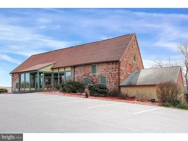
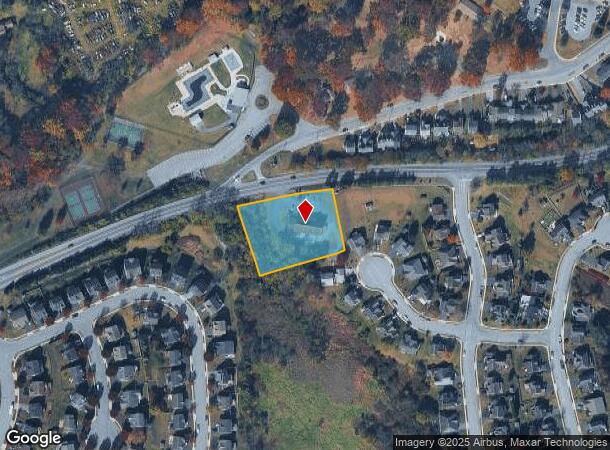
Property Record
2887 N Reading Rd, Adamstown, PA 19501

NEARBY LISTINGS FOR SALE OR LEASE
-
-
View all Adamstown listings for sale on LoopNet.com
Property Detail
2887 N Reading Rd
010-81522-0-0000
2887 N READING RD
Commercialnec
Lancaster
X
Pennsylvania
42071C0202F
3
2024
1.23 AC
2025
Lancaster County
012501
Philadelphia
8,532 SF
Lancaster, PA
DEMOGRAPHICS near 2887 N Reading Rd
1 Mile
3 Mile
5 Mile
2024 Total Population
2,956
10,491
36,555
2029 Population
2,897
10,465
36,578
Pop Growth 2024-2029
(2.00%)
(0.25%)
+ 0.06%
Average Age
41
41
41
2024 Total Households
1,125
3,879
13,229
HH Growth 2024-2029
(1.96%)
(0.31%)
+ 0.04%
Median Household Inc
$107,409
$101,067
$91,562
Avg Household Size
2.60
2.70
2.70
2024 Avg HH Vehicles
2.00
2.00
2.00
Median Home Value
$239,160
$266,100
$259,611
Median Year Built
1990
1983
1981
Nearby Places
Map Layers
Map Styles
 Street
 Aerial
- Restaurants
- Banks
- Shops
- Fitness
- Groceries
SALE & LEASE HISTORY
LISTING DATE
SALE/LEASE

Sep 24, 2016
For Sale
Nov 06, 2018
For Sale
Nearby Properties
Address
Land Use
TOTAL SIZE
Lot Size
Zoning
Address
Land Use
TOTAL SIZE
Lot Size
Zoning
1,588,498 SF
150.55 AC
I-1
Address
Land Use
TOTAL SIZE
Lot Size
Zoning
13,192 SF
9.20 AC
C-1
Address
Land Use
TOTAL SIZE
Lot Size
Zoning
561,324 SF
114.10 AC
I-1
Address
Land Use
TOTAL SIZE
Lot Size
Zoning
97,573 SF
33.72 AC
I1
Address
Land Use
TOTAL SIZE
Lot Size
Zoning
170,735 SF
18.76 AC
Address
Land Use
TOTAL SIZE
Lot Size
Zoning
95,121 SF
23.68 AC
Address
Land Use
TOTAL SIZE
Lot Size
Zoning
117,000 SF
12.98 AC
I-1
Address
Land Use
TOTAL SIZE
Lot Size
Zoning
213,220 SF
22.80 AC
I-1
Address
Land Use
TOTAL SIZE
Lot Size
Zoning
107,888 SF
28.30 AC
I-2
Address
Land Use
TOTAL SIZE
Lot Size
Zoning
75,227 SF
10.60 AC
R-60
Address
Land Use
TOTAL SIZE
Lot Size
Zoning
91,630 SF
16.56 AC
I-1
Address
Land Use
TOTAL SIZE
Lot Size
Zoning
41,012 SF
2.49 AC
C-1
Address
Land Use
TOTAL SIZE
Lot Size
Zoning
270,732 SF
9.50 AC
I-1
Address
Land Use
TOTAL SIZE
Lot Size
Zoning
98,846 SF
32.95 AC
Address
Land Use
TOTAL SIZE
Lot Size
Zoning
50,389 SF
10.07 AC
C-1
Address
Land Use
TOTAL SIZE
Lot Size
Zoning
128,000 SF
8.28 AC
I-1
Address
Land Use
TOTAL SIZE
Lot Size
Zoning
91,642 SF
11.30 AC
I-1
Address
Land Use
TOTAL SIZE
Lot Size
Zoning
94,918 SF
10 AC
I-1
Address
Land Use
TOTAL SIZE
Lot Size
Zoning
133,904 SF
6.70 AC
I-1
Address
Land Use
TOTAL SIZE
Lot Size
Zoning
82,750 SF
5.80 AC
I-1
Address
Land Use
TOTAL SIZE
Lot Size
Zoning
52,974 SF
12.40 AC
Address
Land Use
TOTAL SIZE
Lot Size
Zoning
68,000 SF
8.10 AC
I-1
Address
Land Use
TOTAL SIZE
Lot Size
Zoning
29,503 SF
6.39 AC
Address
Land Use
TOTAL SIZE
Lot Size
Zoning
28,857 SF
97.80 AC
Q
Address
Land Use
TOTAL SIZE
Lot Size
Zoning
98,042 SF
16.79 AC
HC
Address
Land Use
TOTAL SIZE
Lot Size
Zoning
10,399 SF
107.90 AC
AG
Address
Land Use
TOTAL SIZE
Lot Size
Zoning
64,302 SF
7.75 AC
C1
Address
Land Use
TOTAL SIZE
Lot Size
Zoning
70,188 SF
5.40 AC
I-1
Address
Land Use
TOTAL SIZE
Lot Size
Zoning
64,446 SF
9.20 AC
MR
Address
Land Use
TOTAL SIZE
Lot Size
Zoning
21,286 SF
88.30 AC
AG
The World's #1 Commercial Real Estate Marketplace
Connect with us
© 2025 CoStar Group
The information above has been obtained from sources believed reliable. While we do not doubt its accuracy we have not verified it and make no guarantee, warranty or representation about it. It is your responsibility to independently confirm its accuracy and completeness. Any projections, opinions, assumptions, or estimates used are for example only and do not represent the current or future performance of the property. The value of this transaction to you depends on tax and other factors which should be evaluated by your tax, financial, and legal advisors. You and your advisors should conduct a careful, independent investigation of the property to determine to your satisfaction the suitability of the property for your needs.