Property Record
2888 Highway 70 E, Lonoke, AR 72086
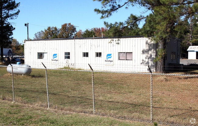

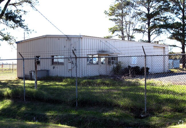
Property Detail
2888 Highway 70 E
001-05671-000
PT N SW & PT N SE
Warehouse
Lonoke
B and X Area of moderate flood hazard, usually the area between the limits of the 100-year and 500-year floods.
Arkansas
2023
2.03 AC
2025
Lonoke County
020500
Little Rock/N Little Rock
9,910 SF
Little Rock-North Little Rock-Conway, AR
NEARBY LISTINGS FOR SALE OR LEASE
-
-
View all Lonoke listings for sale on LoopNet.com
DEMOGRAPHICS near 2888 Highway 70 E
1 mile
3 mile
5 mile
2025 Total Population
21
3,801
5,351
2030 Population
21
3,923
5,504
Pop Growth 2025-2030
0.00%
+ 3.21%
+ 2.86%
Average Age
42
41
41
2025 Total Households
8
1,433
2,018
HH Growth 2025-2030
0.00%
+ 3.42%
+ 3.02%
Median Household Inc
$47,500
$48,984
$53,218
Avg Household Size
2.20
2.50
2.50
2025 Avg HH Vehicles
1.00
2.00
2.00
Median Home Value
$74,999
$115,555
$148,711
Median Year Built
1974
1978
1978
Nearby Places
Map Layers
Map Styles
 Street
 Aerial
Transit
 Traffic
 Biking
Places
Listings with unknown addresses are not visible on the map
- Restaurants
- Banks
- Shops
- Fitness
- Groceries
PUBLIC TRANSPORTATION
AIRPORT
Bill and Hillary Clinton Ntl/Adams Field
Drive
Walk
Distance
Bill and Hillary Clinton Ntl/Adams Field
35 min
27.8 mi
Freight Ports
Port of Shreveport
Drive
Walk
Distance
Port of Shreveport
283 min
260.7 mi
Nearby Properties
Address
Land Use
TOTAL SIZE
Lot Size
Zoning
Address
Land Use
TOTAL SIZE
Lot Size
Zoning
99,052 SF
11.13 AC
Address
Land Use
TOTAL SIZE
Lot Size
Zoning
39,252 SF
3.81 AC
Address
Land Use
TOTAL SIZE
Lot Size
Zoning
65,784 SF
8.79 AC
Address
Land Use
TOTAL SIZE
Lot Size
Zoning
39,594 SF
2.03 AC
Address
Land Use
TOTAL SIZE
Lot Size
Zoning
40,737 SF
3.17 AC
Address
Land Use
TOTAL SIZE
Lot Size
Zoning
116,342 SF
31.82 AC
Address
Land Use
TOTAL SIZE
Lot Size
Zoning
14,423 SF
0.64 AC
Address
Land Use
TOTAL SIZE
Lot Size
Zoning
9,938 SF
4.58 AC
Address
Land Use
TOTAL SIZE
Lot Size
Zoning
25,544 SF
1.97 AC
Address
Land Use
TOTAL SIZE
Lot Size
Zoning
46,512 SF
1.34 AC
Address
Land Use
TOTAL SIZE
Lot Size
Zoning
23,916 SF
1.03 AC
Address
Land Use
TOTAL SIZE
Lot Size
Zoning
15,665 SF
7.02 AC
Address
Land Use
TOTAL SIZE
Lot Size
Zoning
43,190 SF
22.67 AC
Address
Land Use
TOTAL SIZE
Lot Size
Zoning
10,513 SF
1.86 AC
Address
Land Use
TOTAL SIZE
Lot Size
Zoning
16,434 SF
2.02 AC
Address
Land Use
TOTAL SIZE
Lot Size
Zoning
25,579 SF
3 AC
Address
Land Use
TOTAL SIZE
Lot Size
Zoning
4,222 SF
1.96 AC
Address
Land Use
TOTAL SIZE
Lot Size
Zoning
4,310 SF
0.26 AC
Address
Land Use
TOTAL SIZE
Lot Size
Zoning
16,014 SF
1.32 AC
Address
Land Use
TOTAL SIZE
Lot Size
Zoning
30,000 SF
10.07 AC
Address
Land Use
TOTAL SIZE
Lot Size
Zoning
3,420 SF
2.78 AC
Address
Land Use
TOTAL SIZE
Lot Size
Zoning
8,070 SF
0.32 AC
Address
Land Use
TOTAL SIZE
Lot Size
Zoning
3,870 SF
0.97 AC
Address
Land Use
TOTAL SIZE
Lot Size
Zoning
12,800 SF
1.05 AC
Address
Land Use
TOTAL SIZE
Lot Size
Zoning
19,196 SF
25.91 AC
Address
Land Use
TOTAL SIZE
Lot Size
Zoning
3,076 SF
1.49 AC
Address
Land Use
TOTAL SIZE
Lot Size
Zoning
4,280 SF
0.95 AC
Address
Land Use
TOTAL SIZE
Lot Size
Zoning
3,684 SF
1.82 AC
Address
Land Use
TOTAL SIZE
Lot Size
Zoning
6,062 SF
0.80 AC
Address
Land Use
TOTAL SIZE
Lot Size
Zoning
5,440 SF
1.16 AC
The World's #1 Commercial Real Estate Marketplace
Connect with us
© 2026 CoStar Group
The information above has been obtained from sources believed reliable. While we do not doubt its accuracy we have not verified it and make no guarantee, warranty or representation about it. It is your responsibility to independently confirm its accuracy and completeness. Any projections, opinions, assumptions, or estimates used are for example only and do not represent the current or future performance of the property. The value of this transaction to you depends on tax and other factors which should be evaluated by your tax, financial, and legal advisors. You and your advisors should conduct a careful, independent investigation of the property to determine to your satisfaction the suitability of the property for your needs.