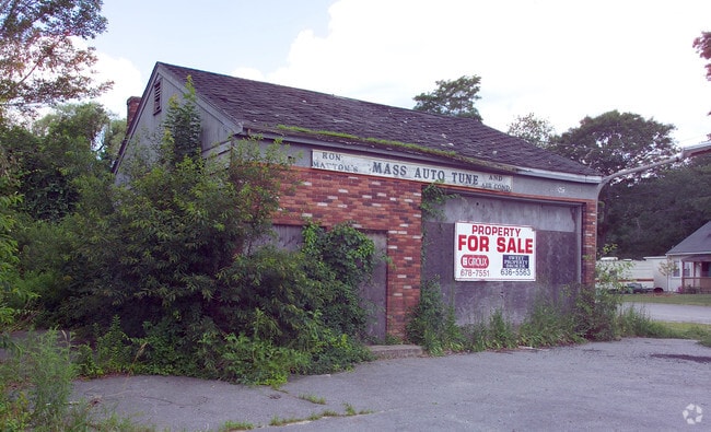
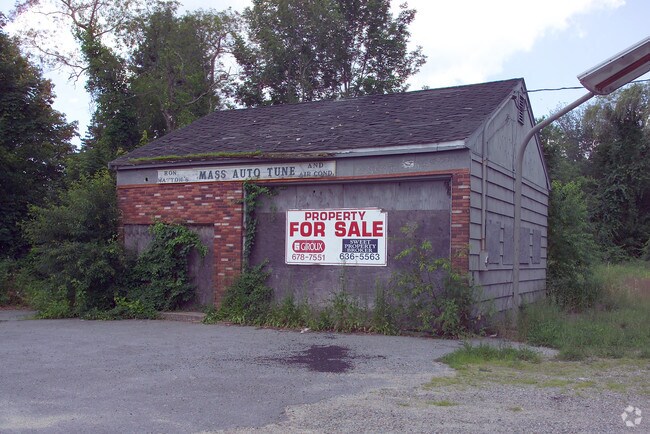
Property Record
289 Main St, Acushnet, MA 02743

Property Detail
289 Main St
ACUS-000024-000104
Bristol
Multifamilydwelling
Massachusetts
B and X Area of moderate flood hazard, usually the area between the limits of the 100-year and 500-year floods.
0.48 AC
2025
Attleboro/New Bedford
2025
Boston
654200
Providence-Warwick, RI-MA
1,680 SF
NEARBY LISTINGS FOR SALE OR LEASE
-
-
View all Acushnet listings for sale on LoopNet.com
DEMOGRAPHICS near 289 Main St
1 mile
3 mile
5 mile
2025 Total Population
3,254
47,770
108,972
2030 Population
3,287
47,959
109,204
Pop Growth 2025-2030
+ 1.01%
+ 0.40%
+ 0.21%
Average Age
44
41
41
2025 Total Households
1,330
19,794
44,853
HH Growth 2025-2030
+ 0.98%
+ 0.42%
+ 0.23%
Median Household Inc
$80,237
$66,712
$66,016
Avg Household Size
2.40
2.30
2.30
2025 Avg HH Vehicles
2.00
2.00
2.00
Median Home Value
$417,206
$392,771
$399,983
Median Year Built
1961
1952
1950
Nearby Places
Map Layers
Map Styles
 Street
 Aerial
Layers
 Traffic
 Biking
Places
Listings with unknown addresses are not visible on the map
- Restaurants
- Banks
- Shops
- Fitness
- Groceries
PUBLIC TRANSPORTATION
AIRPORT
Rhode Island Tf Green International
Drive
Walk
Distance
Rhode Island Tf Green International
59 min
40.0 mi
Freight Ports
Port of New Bedford Harbor
Drive
Walk
Distance
Port of New Bedford Harbor
11 min
5.1 mi
Nearby Properties
Address
Land Use
TOTAL SIZE
Lot Size
Zoning
Address
Land Use
TOTAL SIZE
Lot Size
Zoning
23.22 AC
RB
Address
Land Use
TOTAL SIZE
Lot Size
Zoning
243,052 SF
9.66 AC
RB
Address
Land Use
TOTAL SIZE
Lot Size
Zoning
54.60 AC
Address
Land Use
TOTAL SIZE
Lot Size
Zoning
160,391 SF
2.86 AC
MUB
Address
Land Use
TOTAL SIZE
Lot Size
Zoning
214,698 SF
4.66 AC
IB
Address
Land Use
TOTAL SIZE
Lot Size
Zoning
24.95 AC
PB
Address
Land Use
TOTAL SIZE
Lot Size
Zoning
11.67 AC
RC
Address
Land Use
TOTAL SIZE
Lot Size
Zoning
134,355 SF
2.21 AC
IB
Address
Land Use
TOTAL SIZE
Lot Size
Zoning
183,196 SF
8.14 AC
MUB
Address
Land Use
TOTAL SIZE
Lot Size
Zoning
116,158 SF
3.80 AC
IB
Address
Land Use
TOTAL SIZE
Lot Size
Zoning
225,292 SF
29.27 AC
IC
Address
Land Use
TOTAL SIZE
Lot Size
Zoning
6.46 AC
MUB
Address
Land Use
TOTAL SIZE
Lot Size
Zoning
165,183 SF
11.29 AC
PB
Address
Land Use
TOTAL SIZE
Lot Size
Zoning
5.49 AC
RB
Address
Land Use
TOTAL SIZE
Lot Size
Zoning
85.25 AC
MUB
Address
Land Use
TOTAL SIZE
Lot Size
Zoning
5.30 AC
RC
Address
Land Use
TOTAL SIZE
Lot Size
Zoning
39,910 SF
2.29 AC
RB
Address
Land Use
TOTAL SIZE
Lot Size
Zoning
381.39 AC
Address
Land Use
TOTAL SIZE
Lot Size
Zoning
9.79 AC
IA
Address
Land Use
TOTAL SIZE
Lot Size
Zoning
71.14 AC
RA
Address
Land Use
TOTAL SIZE
Lot Size
Zoning
118,757 SF
61.52 AC
IC
Address
Land Use
TOTAL SIZE
Lot Size
Zoning
47,962 SF
7 AC
B
Address
Land Use
TOTAL SIZE
Lot Size
Zoning
62,408 SF
12.60 AC
RA
Address
Land Use
TOTAL SIZE
Lot Size
Zoning
5.64 AC
MUB
Address
Land Use
TOTAL SIZE
Lot Size
Zoning
135,204 SF
1.74 AC
IB
Address
Land Use
TOTAL SIZE
Lot Size
Zoning
54,513 SF
4.28 AC
IA
Address
Land Use
TOTAL SIZE
Lot Size
Zoning
407,901 SF
9.54 AC
IB
Address
Land Use
TOTAL SIZE
Lot Size
Zoning
6.54 AC
IB
Address
Land Use
TOTAL SIZE
Lot Size
Zoning
46,083 SF
8.43 AC
MUB
Address
Land Use
TOTAL SIZE
Lot Size
Zoning
130,695 SF
2.24 AC
IB
The World's #1 Commercial Real Estate Marketplace
Connect with us
© 2026 CoStar Group
The information above has been obtained from sources believed reliable. While we do not doubt its accuracy we have not verified it and make no guarantee, warranty or representation about it. It is your responsibility to independently confirm its accuracy and completeness. Any projections, opinions, assumptions, or estimates used are for example only and do not represent the current or future performance of the property. The value of this transaction to you depends on tax and other factors which should be evaluated by your tax, financial, and legal advisors. You and your advisors should conduct a careful, independent investigation of the property to determine to your satisfaction the suitability of the property for your needs.