Property Record
289 N Loop 289 Ave N, Lubbock, TX 79416
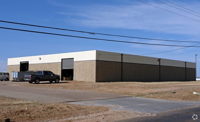

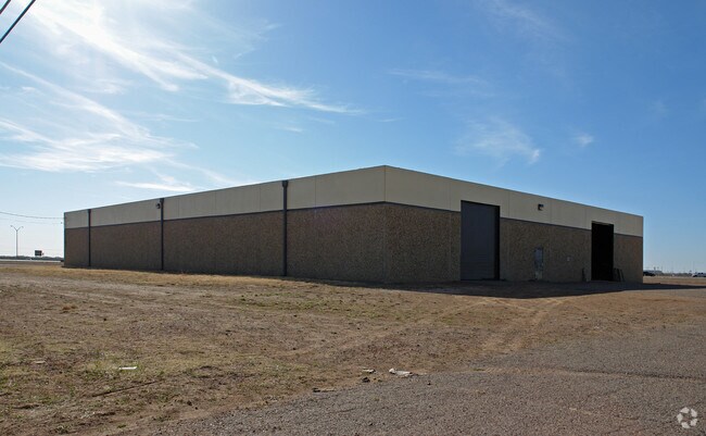
Property Detail
289 N Loop 289 Ave N
Lubbock, TX
PHYSICIANS SURGICENTER LUBBOCK BAL OF TR A
R160033
LUBBOCK
Residentialacreage
Texas
C and X Area of minimal flood hazard, usually depicted on FIRMs as above the 500-year flood level.
a
2024
4.01 AC
2025
North Outer Lubbock
010417
Lubbock
NEARBY LISTINGS FOR SALE OR LEASE
DEMOGRAPHICS near 289 N Loop 289 Ave N
1 mile
3 mile
5 mile
2025 Total Population
6,192
65,169
146,759
2030 Population
6,247
67,168
152,789
Pop Growth 2025-2030
+ 0.89%
+ 3.07%
+ 4.11%
Average Age
32
33
34
2025 Total Households
2,295
23,727
57,702
HH Growth 2025-2030
+ 0.92%
+ 3.80%
+ 4.66%
Median Household Inc
$44,587
$47,872
$48,873
Avg Household Size
2.60
2.40
2.30
2025 Avg HH Vehicles
2.00
2.00
2.00
Median Home Value
$234,545
$190,544
$175,841
Median Year Built
2002
1985
1978
Nearby Places
Map Layers
Map Styles
 Street
 Aerial
Transit
 Traffic
 Biking
Places
Listings with unknown addresses are not visible on the map
- Restaurants
- Banks
- Shops
- Fitness
- Groceries
PUBLIC TRANSPORTATION
AIRPORT
Lubbock Preston Smith International
Drive
Walk
Distance
Lubbock Preston Smith International
25 min
13.1 mi
Freight Ports
Tulsa Port Of Catoosa
Drive
Walk
Distance
Tulsa Port Of Catoosa
509 min
471.9 mi
Nearby Properties
Address
Land Use
TOTAL SIZE
Lot Size
Zoning
Address
Land Use
TOTAL SIZE
Lot Size
Zoning
103,717 SF
25.26 AC
Address
Land Use
TOTAL SIZE
Lot Size
Zoning
380,785 SF
36.72 AC
Address
Land Use
TOTAL SIZE
Lot Size
Zoning
379,029 SF
29.43 AC
Address
Land Use
TOTAL SIZE
Lot Size
Zoning
351,150 SF
3.65 AC
Address
Land Use
TOTAL SIZE
Lot Size
Zoning
342,611 SF
12.21 AC
Address
Land Use
TOTAL SIZE
Lot Size
Zoning
409,380 SF
30.13 AC
Address
Land Use
TOTAL SIZE
Lot Size
Zoning
321,540 SF
10.87 AC
Address
Land Use
TOTAL SIZE
Lot Size
Zoning
286,541 SF
4.25 AC
Address
Land Use
TOTAL SIZE
Lot Size
Zoning
360,108 SF
18.63 AC
Address
Land Use
TOTAL SIZE
Lot Size
Zoning
304,276 SF
22.69 AC
Address
Land Use
TOTAL SIZE
Lot Size
Zoning
244,983 SF
14.26 AC
Address
Land Use
TOTAL SIZE
Lot Size
Zoning
179,627 SF
2.66 AC
Address
Land Use
TOTAL SIZE
Lot Size
Zoning
274,547 SF
18.92 AC
Address
Land Use
TOTAL SIZE
Lot Size
Zoning
473,857 SF
17.64 AC
Address
Land Use
TOTAL SIZE
Lot Size
Zoning
355,384 SF
19.63 AC
Address
Land Use
TOTAL SIZE
Lot Size
Zoning
244,834 SF
14.54 AC
Address
Land Use
TOTAL SIZE
Lot Size
Zoning
230,286 SF
8.01 AC
Address
Land Use
TOTAL SIZE
Lot Size
Zoning
122,976 SF
14.50 AC
Address
Land Use
TOTAL SIZE
Lot Size
Zoning
396,570 SF
2.56 AC
Address
Land Use
TOTAL SIZE
Lot Size
Zoning
88,803 SF
7.23 AC
Address
Land Use
TOTAL SIZE
Lot Size
Zoning
106,894 SF
5.83 AC
Address
Land Use
TOTAL SIZE
Lot Size
Zoning
400,401 SF
2.76 AC
Address
Land Use
TOTAL SIZE
Lot Size
Zoning
207.36 AC
Address
Land Use
TOTAL SIZE
Lot Size
Zoning
102,209 SF
14 AC
Address
Land Use
TOTAL SIZE
Lot Size
Zoning
64,800 SF
0.94 AC
Address
Land Use
TOTAL SIZE
Lot Size
Zoning
153,416 SF
3.14 AC
Address
Land Use
TOTAL SIZE
Lot Size
Zoning
176,412 SF
12.27 AC
Address
Land Use
TOTAL SIZE
Lot Size
Zoning
67,759 SF
6.37 AC
Address
Land Use
TOTAL SIZE
Lot Size
Zoning
152,857 SF
7.87 AC
Address
Land Use
TOTAL SIZE
Lot Size
Zoning
143,905 SF
0.28 AC
The World's #1 Commercial Real Estate Marketplace
Connect with us
© 2026 CoStar Group
The information above has been obtained from sources believed reliable. While we do not doubt its accuracy we have not verified it and make no guarantee, warranty or representation about it. It is your responsibility to independently confirm its accuracy and completeness. Any projections, opinions, assumptions, or estimates used are for example only and do not represent the current or future performance of the property. The value of this transaction to you depends on tax and other factors which should be evaluated by your tax, financial, and legal advisors. You and your advisors should conduct a careful, independent investigation of the property to determine to your satisfaction the suitability of the property for your needs.