Property Record
2890 Highway 247 Hwy, Byron, GA 31008

Property Detail
2890 Highway 247 Hwy
Warner Robins, GA
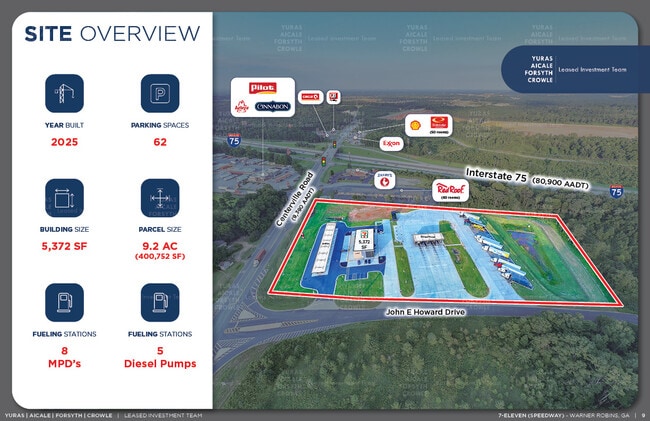
NEW PARCEL #2 / 10.503 AC
052B-065-A
PEACH
Commercialacreage
Georgia
C-2 WR
#2
B and X Area of moderate flood hazard, usually the area between the limits of the 100-year and 500-year floods.
10.50 AC
2025
Perry/Warner Robins
2025
Other Market Areas
040103
NEARBY LISTINGS FOR SALE OR LEASE
DEMOGRAPHICS near 2890 Highway 247 Hwy
1 mile
3 mile
5 mile
2025 Total Population
746
18,808
58,739
2030 Population
779
19,620
61,448
Pop Growth 2025-2030
+ 4.42%
+ 4.32%
+ 4.61%
Average Age
44
41
39
2025 Total Households
307
7,547
22,707
HH Growth 2025-2030
+ 4.56%
+ 4.35%
+ 4.67%
Median Household Inc
$71,718
$85,578
$83,101
Avg Household Size
2.40
2.50
2.60
2025 Avg HH Vehicles
2.00
2.00
2.00
Median Home Value
$257,009
$237,055
$236,458
Median Year Built
2005
2001
1999
Nearby Places
Map Layers
Map Styles
 Street
 Aerial
Transit
 Traffic
 Biking
Places
Listings with unknown addresses are not visible on the map
- Restaurants
- Banks
- Shops
- Fitness
- Groceries
SALE & LEASE HISTORY
LISTING DATE
SALE/LEASE

Dec 04, 2024
For Sale
Nearby Properties
Address
Land Use
TOTAL SIZE
Lot Size
Zoning
Address
Land Use
TOTAL SIZE
Lot Size
Zoning
503,585 SF
61.05 AC
C-2, WR
Address
Land Use
TOTAL SIZE
Lot Size
Zoning
18,954 SF
20 AC
C2
Address
Land Use
TOTAL SIZE
Lot Size
Zoning
9,600 SF
24.25 AC
C-H
Address
Land Use
TOTAL SIZE
Lot Size
Zoning
61,158 SF
26.31 AC
PUD
Address
Land Use
TOTAL SIZE
Lot Size
Zoning
5,640 SF
28 AC
PDE
Address
Land Use
TOTAL SIZE
Lot Size
Zoning
338,708 SF
28.28 AC
M-2 WR
Address
Land Use
TOTAL SIZE
Lot Size
Zoning
68,545 SF
19.94 AC
MULTI
Address
Land Use
TOTAL SIZE
Lot Size
Zoning
560 SF
24.73 AC
R4
Address
Land Use
TOTAL SIZE
Lot Size
Zoning
225,751 SF
100 AC
M-1, WR
Address
Land Use
TOTAL SIZE
Lot Size
Zoning
63,274 SF
40.27 AC
C-2, WR
Address
Land Use
TOTAL SIZE
Lot Size
Zoning
62,173 SF
17.70 AC
C2
Address
Land Use
TOTAL SIZE
Lot Size
Zoning
5,320 SF
15.47 AC
R-4
Address
Land Use
TOTAL SIZE
Lot Size
Zoning
10,000 SF
43.93 AC
I-1
Address
Land Use
TOTAL SIZE
Lot Size
Zoning
94,274 SF
28.34 AC
R-AG
Address
Land Use
TOTAL SIZE
Lot Size
Zoning
60,300 SF
6.99 AC
M-2, WR
Address
Land Use
TOTAL SIZE
Lot Size
Zoning
54,835 SF
1.76 AC
C2
Address
Land Use
TOTAL SIZE
Lot Size
Zoning
57,823 SF
2.59 AC
C2
Address
Land Use
TOTAL SIZE
Lot Size
Zoning
80,825 SF
7.20 AC
I-1
Address
Land Use
TOTAL SIZE
Lot Size
Zoning
108,660 SF
13.96 AC
R4
Address
Land Use
TOTAL SIZE
Lot Size
Zoning
418,404 SF
17.99 AC
C-H
Address
Land Use
TOTAL SIZE
Lot Size
Zoning
50,524 SF
3 AC
C2
Address
Land Use
TOTAL SIZE
Lot Size
Zoning
8,640 SF
12.49 AC
R-AG
Address
Land Use
TOTAL SIZE
Lot Size
Zoning
24,908 SF
2.86 AC
C2
Address
Land Use
TOTAL SIZE
Lot Size
Zoning
23,100 SF
5.39 AC
C2
Address
Land Use
TOTAL SIZE
Lot Size
Zoning
106,830 SF
20.82 AC
C-H
Address
Land Use
TOTAL SIZE
Lot Size
Zoning
944 SF
294.54 AC
M-2 WR
Address
Land Use
TOTAL SIZE
Lot Size
Zoning
14,140 SF
16.59 AC
R1
Address
Land Use
TOTAL SIZE
Lot Size
Zoning
46,760 SF
1.48 AC
C2
Address
Land Use
TOTAL SIZE
Lot Size
Zoning
17,588 SF
1.63 AC
C2
Address
Land Use
TOTAL SIZE
Lot Size
Zoning
58,534 SF
7.82 AC
MULTI
The World's #1 Commercial Real Estate Marketplace
Connect with us
© 2026 CoStar Group
The information above has been obtained from sources believed reliable. While we do not doubt its accuracy we have not verified it and make no guarantee, warranty or representation about it. It is your responsibility to independently confirm its accuracy and completeness. Any projections, opinions, assumptions, or estimates used are for example only and do not represent the current or future performance of the property. The value of this transaction to you depends on tax and other factors which should be evaluated by your tax, financial, and legal advisors. You and your advisors should conduct a careful, independent investigation of the property to determine to your satisfaction the suitability of the property for your needs.