Property Record
2890 Inland Empire Blvd, Ontario, CA 91764
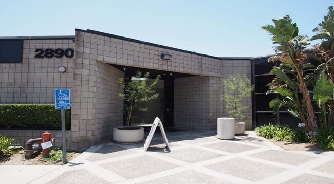

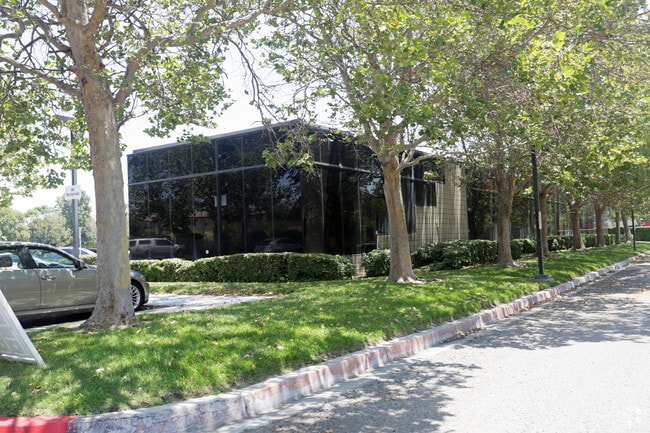

This Property Is For Sale
Current Lease Availabilities
NEARBY LISTINGS FOR SALE OR LEASE
Property Detail
2890 Inland Empire Blvd
0210-191-19
San Antonio Heights Tract
Officebuilding
PARCEL MAP 11208 PARCEL 1
X
San Bernardino
06071C8629H
California
2024
1.57 AC
2025
Airport Area
002109
Inland Empire (California)
19,907 SF
Riverside-San Bernardino-Ontario, CA
DEMOGRAPHICS near 2890 Inland Empire Blvd
1 Mile
3 Mile
5 Mile
2024 Total Population
9,064
91,416
330,356
2029 Population
9,244
92,959
335,895
Pop Growth 2024-2029
+ 1.99%
+ 1.69%
+ 1.68%
Average Age
35
36
37
2024 Total Households
3,186
29,124
105,555
HH Growth 2024-2029
+ 1.66%
+ 1.83%
+ 1.75%
Median Household Inc
$80,596
$73,415
$84,412
Avg Household Size
2.80
3.00
3.00
2024 Avg HH Vehicles
2.00
2.00
2.00
Median Home Value
$523,960
$473,438
$557,997
Median Year Built
1994
1983
1982
Nearby Places
Map Layers
Map Styles
 Street
 Aerial
- Restaurants
- Banks
- Shops
- Fitness
- Groceries
PUBLIC TRANSPORTATION
COMMUTER RAIL
Rancho Cucamonga (San Bernardino Line - Southern California Regional Rail Authority (Metrolink))
DRIVE
WALK
Distance
Rancho Cucamonga (San Bernardino Line - Southern California Regional Rail Authority (Metrolink))
8 min
3.4 mi
East Ontario (Riverside Line - Southern California Regional Rail Authority (Metrolink))
DRIVE
WALK
Distance
East Ontario (Riverside Line - Southern California Regional Rail Authority (Metrolink))
7 min
3.4 mi
AIRPORT
Ontario International
DRIVE
WALK
Distance
Ontario International
5 min
1.8 mi
John Wayne/Orange County
DRIVE
WALK
Distance
John Wayne/Orange County
54 min
43.6 mi
Nearby Properties
Address
Land Use
TOTAL SIZE
Lot Size
Zoning
Address
Land Use
TOTAL SIZE
Lot Size
Zoning
1,281,803 SF
27.85 AC
Address
Land Use
TOTAL SIZE
Lot Size
Zoning
1,459,702 SF
96.41 AC
Address
Land Use
TOTAL SIZE
Lot Size
Zoning
244,370 SF
59.72 AC
Address
Land Use
TOTAL SIZE
Lot Size
Zoning
707,551 SF
20.36 AC
Address
Land Use
TOTAL SIZE
Lot Size
Zoning
539,128 SF
10.24 AC
Address
Land Use
TOTAL SIZE
Lot Size
Zoning
293,860 SF
16.10 AC
Address
Land Use
TOTAL SIZE
Lot Size
Zoning
545,161 SF
11.10 AC
Address
Land Use
TOTAL SIZE
Lot Size
Zoning
453,960 SF
18.54 AC
Address
Land Use
TOTAL SIZE
Lot Size
Zoning
591,495 SF
18.29 AC
Address
Land Use
TOTAL SIZE
Lot Size
Zoning
1,052,840 SF
41.85 AC
Address
Land Use
TOTAL SIZE
Lot Size
Zoning
531,988 SF
9.83 AC
Address
Land Use
TOTAL SIZE
Lot Size
Zoning
286,732 SF
9.58 AC
Address
Land Use
TOTAL SIZE
Lot Size
Zoning
261,357 SF
10.03 AC
Address
Land Use
TOTAL SIZE
Lot Size
Zoning
440,209 SF
10.34 AC
Address
Land Use
TOTAL SIZE
Lot Size
Zoning
830,300 SF
39.99 AC
Address
Land Use
TOTAL SIZE
Lot Size
Zoning
317,070 SF
14.26 AC
Address
Land Use
TOTAL SIZE
Lot Size
Zoning
190,724 SF
10.69 AC
Address
Land Use
TOTAL SIZE
Lot Size
Zoning
387,965 SF
10.92 AC
Address
Land Use
TOTAL SIZE
Lot Size
Zoning
817,493 SF
93.45 AC
Address
Land Use
TOTAL SIZE
Lot Size
Zoning
797,408 SF
66.66 AC
Address
Land Use
TOTAL SIZE
Lot Size
Zoning
709,814 SF
29.40 AC
Address
Land Use
TOTAL SIZE
Lot Size
Zoning
252,800 SF
12.90 AC
Address
Land Use
TOTAL SIZE
Lot Size
Zoning
468,682 SF
19.40 AC
Address
Land Use
TOTAL SIZE
Lot Size
Zoning
174,092 SF
4.42 AC
Address
Land Use
TOTAL SIZE
Lot Size
Zoning
656,040 SF
28.47 AC
Address
Land Use
TOTAL SIZE
Lot Size
Zoning
358,375 SF
9.30 AC
Address
Land Use
TOTAL SIZE
Lot Size
Zoning
183,039 SF
8.30 AC
Address
Land Use
TOTAL SIZE
Lot Size
Zoning
151,805 SF
10.59 AC
CM
Address
Land Use
TOTAL SIZE
Lot Size
Zoning
246,012 SF
5.97 AC
Address
Land Use
TOTAL SIZE
Lot Size
Zoning
155,076 SF
7.38 AC
The World's #1 Commercial Real Estate Marketplace
Connect with us
© 2025 CoStar Group
The information above has been obtained from sources believed reliable. While we do not doubt its accuracy we have not verified it and make no guarantee, warranty or representation about it. It is your responsibility to independently confirm its accuracy and completeness. Any projections, opinions, assumptions, or estimates used are for example only and do not represent the current or future performance of the property. The value of this transaction to you depends on tax and other factors which should be evaluated by your tax, financial, and legal advisors. You and your advisors should conduct a careful, independent investigation of the property to determine to your satisfaction the suitability of the property for your needs.